Natural Resources
Conservation Service
Ecological site R030XA044CA
Droughty Sand 5-7" p.z.
Last updated: 2/18/2025
Accessed: 05/11/2025
General information
Provisional. A provisional ecological site description has undergone quality control and quality assurance review. It contains a working state and transition model and enough information to identify the ecological site.
Ecological site concept
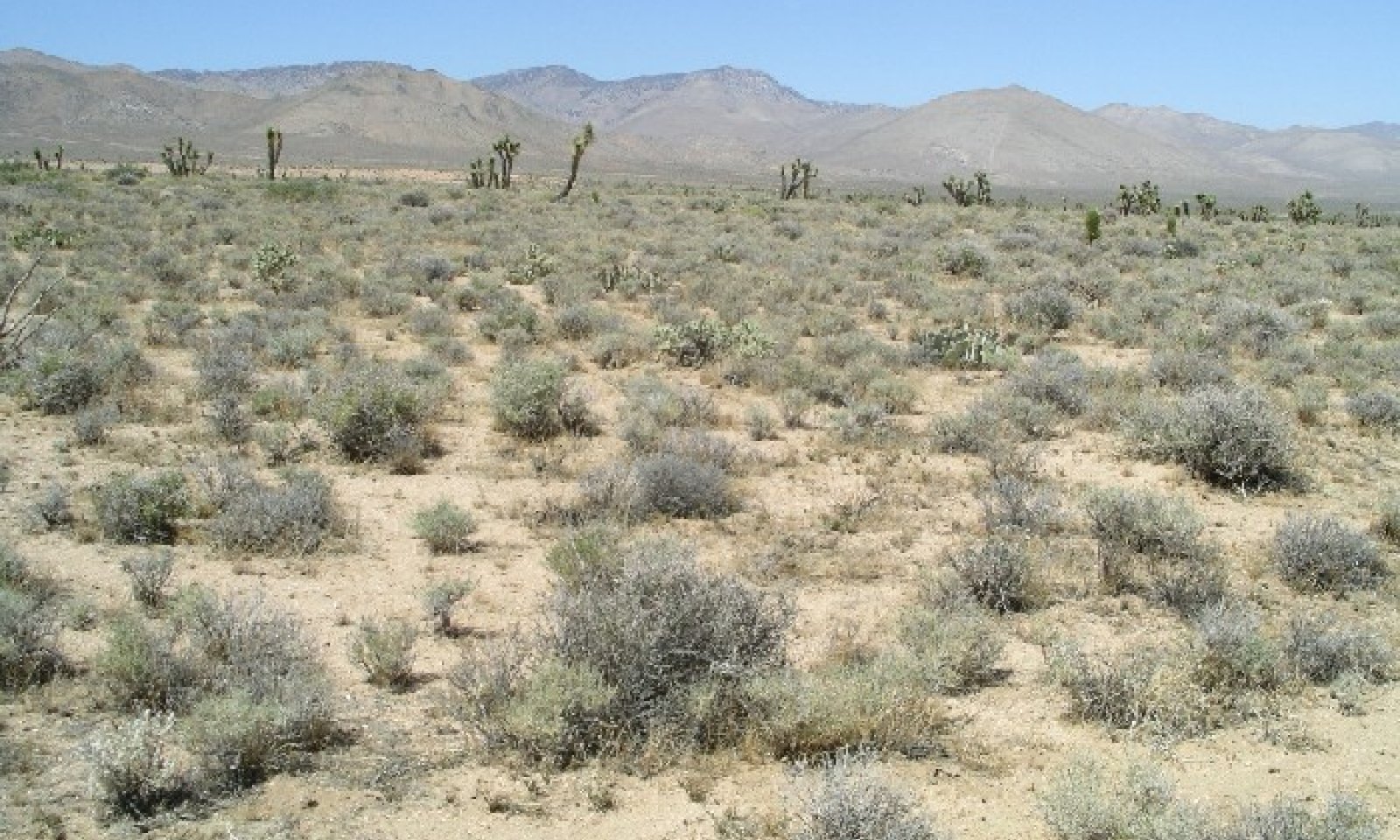
This ecological site is found on fan remnants. Slopes range from 4 to 15 percent.
Soils are very shallow to shallow to an argillic horizon.
Similar sites
| R030XA017CA |
Droughty Loam 5-7" P.Z. R030XA017CA Droughty Loam 5-7 |
|---|
Table 1. Dominant plant species
| Tree |
Not specified |
|---|---|
| Shrub |
(1) Ambrosia dumosa |
| Herbaceous |
(1) Poa secunda |
Physiographic features
This ecological site is found on fan remnants. Slopes range from 4 to 15 percent.
Table 2. Representative physiographic features
| Landforms |
(1)
Fan remnant
|
|---|---|
| Flooding frequency | None |
| Ponding frequency | None |
| Elevation | 2,300 – 4,200 ft |
| Slope | 4 – 15% |
| Aspect | Aspect is not a significant factor |
Climatic features
The Mojave Desert experiences clear, dry conditions for a majority of the year. Winter temperatures are mild, summer temperatures are hot, and seasonal and diurnal temperature fluctuations are large. Monthly minimum temperature averages range from 30 to 80 degrees F (-1 to 27 degrees C). Monthly maximum temperature averages range from 60 to 110 degrees F (16 to 43 degrees C) (CSU 2002).
Average annual rainfall is between 2 and 8 inches (50 to 205 millimeters) (USDA 2006). Snowfall is more common at elevations above 4000 feet (1220 meters), but it may not occur every year (WRCC 2002). The Mojave Desert receives precipitation from two sources. Precipitation falls primarily in the winter as a result of storms originating in the northern Pacific Ocean. The Sierra Nevada and Transverse Ranges create a rain shadow effect, causing little precipitation to reach the Mojave Desert. Sporadic rainfall occurs during the summer as a result of convection storms formed when moisture from the Gulf of Mexico or Gulf of California moves into the region. Summer rainfall is more common and has a greater influence on soil moisture in the eastern Mojave Desert.
Windy conditions are also common in the Mojave Desert, particularly in the west and central Mojave Desert. Spring is typically the windiest season, with winds averaging 10-15 miles per hour (WRCC 2002). Winds in excess of 25 miles per hour and gusts in excess of 50 miles per hour are not uncommon (CSU 2002).
Although half of the Jawbone-Butterbredt ACEC Soil Survey is in the Mojave Desert (MLRA 30), the western and northwestern areas of the survey transition into the Southern Nevada Basin and Range (MLRA 29). As the Mojave Desert transitions into the Southern Nevada Basin and Range, the temperature range generally becomes cooler (WRCC 2002). Precipitation as rain and as snow also increases (USDA 2006). This survey area has a wide range of precipitation due to its location. Where the Mojave Desert influences are stronger, average annual precipitation ranges from 5 to 7 inches (127 to 178 millimeters). Where the Southern Nevada Basin and Range influences are stronger, average annual precipitation commonly ranges from 7 to 9 inches (178 to 229 millimeters), and may range up to 12 inches (305 millimeters) annually (WRCC 2002). At elevations above 4000 feet (1370 meters), average annual snowfall may reach 20 inches (WRCC 2002).
The data from the following climate stations were used to describe the climate in the Jawbone-Butterbredt ACEC Soil Survey (station number in parentheses):
Cantil, CA (041488)
Inyokern, CA (044278)
Mojave, CA (045756)
Tehachapi, CA (048826)
"Maximum monthly precipitation" represents average monthly precipitation.
Table 3. Representative climatic features
| Frost-free period (average) | 300 days |
|---|---|
| Freeze-free period (average) | 315 days |
| Precipitation total (average) | 7 in |
Figure 1. Monthly average minimum and maximum temperature
Influencing water features
Soil features
This ecological site is found on very deep (>60 inches), well drained soils formed in older, stable, granitic alluvium. Textures are coarse-loamy with mainly sandy loam textures throughout. Soils are very shallow to shallow to an argillic horizon. Permeability is moderately rapid, runoff is very low, and available water capacity is low to moderate. Soils classify as coarse-loamy, mixed, superactive, thermic Typic Haplargids.
Soil survey area - Map unit symbol - Component
CA682 – 4171 – Dovecanyon, sloping
Table 4. Representative soil features
| Surface texture |
(1) Loamy sand |
|---|---|
| Family particle size |
(1) Loamy |
| Drainage class | Well drained |
| Permeability class | Moderately rapid |
| Soil depth | 60 in |
| Surface fragment cover <=3" | 35 – 60% |
| Surface fragment cover >3" | Not specified |
| Available water capacity (0-40in) |
3.4 – 6.2 in |
| Calcium carbonate equivalent (0-40in) |
1% |
| Electrical conductivity (0-40in) |
2 mmhos/cm |
| Sodium adsorption ratio (0-40in) |
5 |
| Subsurface fragment volume <=3" (Depth not specified) |
5 – 20% |
| Subsurface fragment volume >3" (Depth not specified) |
Not specified |
Ecological dynamics
Please refer to group concept R030XA048CA to view the provisional STM.
This ecological site is influenced by the cooler, moister climate typical of MLRA 29 and being at the upper edge of the warmer, drier climate typical of MLRA 30. This ecological site is located in close proximity to blackbrush (Coleogyne ramosissima)-dominated plant communities. Creosote bush, a dominant plant in MLRA 30, is largely absent from this community. However, white bursage, a common associate of creosote bush, is dominant in this community. The elevational range of white bursage suggests it is more tolerant of cooler temperatures than creosotebush, and may therefore be better adapted to the cooler climatic influences of MLRA 29.
The dominant species on this ecological site are white bursage (Ambrosia dumosa) and Sandberg bluegrass (Poa secunda). Spiny hopsage (Grayia spinosa) is also an important species. White bursage is often found in late seral communities with species such as creosote bush (Larrea tridentata), but it also colonizes disturbed sites through easy seed dispersal (Marshall 1994). Sandberg bluegrass is a common species and grows in a wide range of habitats (Hickman 1993). It is common where disturbances have occurred, but is also found in stable, minimally disturbed plant communities such as blackbrush scrub communities. Spiny hopsage is also present in many desert plant communities. It is a relatively long-lived, mid-seral species (Tirmenstein 1999).
Few invasive annuals such as Mediterranean grass (Schismus arabicus) and red stem stork’s bill (Erodium cicutarium) are currently present on this ecological site, but seeds may be easily transported to this site by animal movement or recreational activities. An increase in invasive species may increase the risk of fire on this ecological site by creating a more continuous, easily ignitable fuel bed (Clarke 2006). White bursage is generally killed by fire but can re-establish on a site by seed. Sandberg bluegrass and spiny hopsage can sprout from their root crowns provided that the fire was not intense. Minor species such as rayless goldenhead (Acamptopappus sphaerocephalus), Cooper’s goldenbush (Ericameria teretifolia), and burrobrush (Hymenoclea salsola) may increase following a fire or other widespread disturbance.
State and transition model
More interactive model formats are also available.
View Interactive Models
Click on state and transition labels to scroll to the respective text
Ecosystem states
State 1 submodel, plant communities
State 1
White bursage - Spiny hopsage - Sandberg bluegrass
Community 1.1
White bursage - Spiny hopsage - Sandberg bluegrass
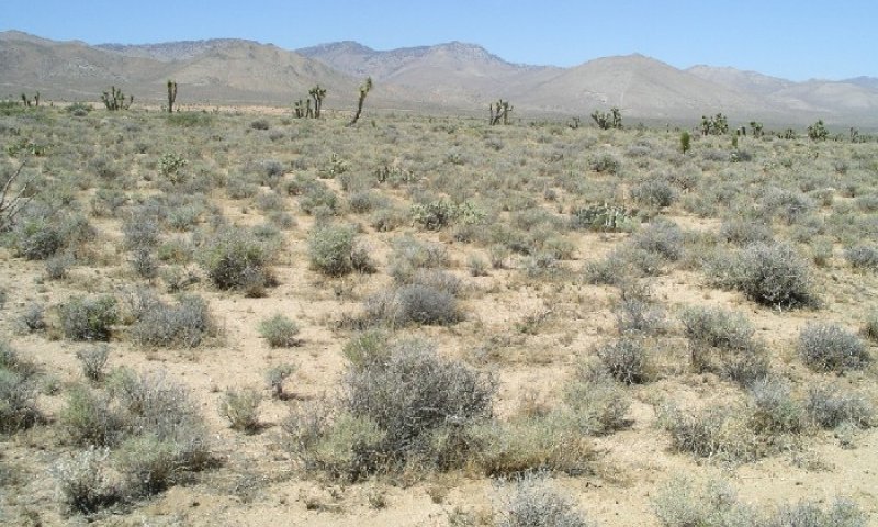
Figure 2. White bursage-sandberg bluegrass
The interpretive plant community is the reference plant community prior to European colonization. The dominant species on this ecological site are white bursage (Ambrosia dumosa) and Sandberg bluegrass (Poa secunda). Spiny hopsage (Grayia spinosa) and winterfat (Krascheninnikovia lanata) are other important shrubs. Other species present in small amounts include creosote bush (Larrea tridentata), and Joshua tree (Yucca brevifolia). The plant community is composed of 60% shrubs, 35% grasses, and 5% annual forbs.
Figure 3. Annual production by plant type (representative values) or group (midpoint values)
Table 5. Annual production by plant type
| Plant type | Low (lb/acre) |
Representative value (lb/acre) |
High (lb/acre) |
|---|---|---|---|
| Shrub/Vine | 122 | 184 | 247 |
| Grass/Grasslike | 68 | 100 | 133 |
| Forb | 10 | 16 | 20 |
| Total | 200 | 300 | 400 |
Table 6. Ground cover
| Tree foliar cover | 0% |
|---|---|
| Shrub/vine/liana foliar cover | 15-20% |
| Grass/grasslike foliar cover | 5-10% |
| Forb foliar cover | 2-3% |
| Non-vascular plants | 0% |
| Biological crusts | 0% |
| Litter | 0% |
| Surface fragments >0.25" and <=3" | 0% |
| Surface fragments >3" | 0% |
| Bedrock | 0% |
| Water | 0% |
| Bare ground | 0% |
Table 7. Soil surface cover
| Tree basal cover | 0% |
|---|---|
| Shrub/vine/liana basal cover | 5-10% |
| Grass/grasslike basal cover | 5-7% |
| Forb basal cover | 2-3% |
| Non-vascular plants | 0% |
| Biological crusts | 0% |
| Litter | 1-2% |
| Surface fragments >0.25" and <=3" | 0% |
| Surface fragments >3" | 0% |
| Bedrock | 0% |
| Water | 0% |
| Bare ground | 0% |
Table 8. Canopy structure (% cover)
| Height Above Ground (ft) | Tree | Shrub/Vine | Grass/ Grasslike |
Forb |
|---|---|---|---|---|
| <0.5 | – | – | – | 2-3% |
| >0.5 <= 1 | – | – | 5-10% | – |
| >1 <= 2 | – | 9-14% | 3-5% | – |
| >2 <= 4.5 | – | 1-2% | – | – |
| >4.5 <= 13 | – | – | – | – |
| >13 <= 40 | – | – | – | – |
| >40 <= 80 | – | – | – | – |
| >80 <= 120 | – | – | – | – |
| >120 | – | – | – | – |
Additional community tables
Table 9. Community 1.1 plant community composition
| Group | Common name | Symbol | Scientific name | Annual production (lb/acre) | Foliar cover (%) | |
|---|---|---|---|---|---|---|
|
Shrub/Vine
|
||||||
| 1 | Perennial Shrubs | 122–247 | ||||
| burrobush | AMDU2 | Ambrosia dumosa | 70–132 | – | ||
| spiny hopsage | GRSP | Grayia spinosa | 16–32 | – | ||
| winterfat | KRLA2 | Krascheninnikovia lanata | 10–20 | – | ||
| Joshua tree | YUBR | Yucca brevifolia | 6–15 | – | ||
| rayless goldenhead | ACSP | Acamptopappus sphaerocephalus | 6–12 | – | ||
| creosote bush | LATR2 | Larrea tridentata | 0–8 | – | ||
| burrobrush | HYSA | Hymenoclea salsola | 4–8 | – | ||
| Nevada jointfir | EPNE | Ephedra nevadensis | 4–8 | – | ||
| Cooper's goldenbush | ERCO23 | Ericameria cooperi | 2–4 | – | ||
| water jacket | LYAN | Lycium andersonii | 2–4 | – | ||
| beavertail pricklypear | OPBA2 | Opuntia basilaris | 2–4 | – | ||
|
Grass/Grasslike
|
||||||
| 2 | Perennial grass | 68–133 | ||||
| Sandberg bluegrass | POSE | Poa secunda | 68–133 | – | ||
|
Forb
|
||||||
| 3 | Annual forbs | 10–20 | ||||
| gilia | GILIA | Gilia | 4–8 | – | ||
| bristly fiddleneck | AMTE3 | Amsinckia tessellata | 1–3 | – | ||
| Pringle's woolly sunflower | ERPR4 | Eriophyllum pringlei | 1–2 | – | ||
Interpretations
Animal community
This ecolgical site provides habitat for many small mammals. Sandberg bluegrass (Poa secunda) is a valuable forage species for both wildlife and domestic livestock. White bursage (Ambrosia dumosa), spiny hopsage (Grayia spinosa), and winterfat (Krascheninnikovia lanata) is also a valuable browse species.
Recreational uses
This ecological site is located in an off-highway vehicle recreation area. Several trails run through this area.
Supporting information
Inventory data references
1 SCS Range 417 Production and Composition Record (2003)
1 Dry weight rank transect (2004)
Type locality
| Location 1: Kern County, CA | |
|---|---|
| UTM zone | N |
| UTM northing | 3929691 |
| UTM easting | 406339 |
| Latitude | 35° 30′ 20″ |
| Longitude | 118° 1′ 58″ |
| General legal description | This site occurs just south of the second Los Angeles Aquaduct road at the junction with SC106 in the Jawbone-Butterbredt ACEC. |
Other references
California State University (CSU) Desert Studies Center. 2002. Desert Climate. CSU Desert Studies Center, Soda Springs, CA. Online. http://biology.fullerton.edu/facilities/dsc/zz_climate.html. Accessed 28 November 2006.
Clarke, C. 2006. The year we lost the deserts. Earth Island Journal. 20(4): 24-56.
Hickman, James C. (Ed.). 1993. The Jepson manual: higher plants of California. University of California Press, Berkeley, CA. 1400 pp.
Marshall, K. Anna. 1994. Ambrosia dumosa. In: Fire Effects Information System, [Online]. U.S. Department of Agriculture, Forest Service, Rocky Mountain Research Station, Fire Sciences Laboratory (Producer). Available: http://www.fs.fed.us/database/feis/ [2007, May 7].
Tirmenstein, D. A. 1999. Grayia spinosa. In: Fire Effects Information System, [Online]. U.S. Department of Agriculture, Forest Service, Rocky Mountain Research Station, Fire Sciences Laboratory (Producer). Available: http://www.fs.fed.us/database/feis/ [ 2007, May 7].
United States Department of Agriculture (USDA), Natural Resources Conservation Service. 2006. Land Resource Regions and Major Land Resource Areas of the United States, the Caribbean, and the Pacific Basin. U.S. Department of Agriculture Handbook 296.
Western Regional Climate Center (WRCC). 2002. Western U.S. Climate Historical Summaries [Online]. Desert Research Institute, Reno, NV. Online. http://www.wrcc.dri.edu/Climsum.html. Accessed 28 November 2006.
Locator map image generated using TopoZone.com © 1999-2004 Maps a la carte, Inc. - All rights reserved.
Contributors
Heath M. McAllister
Approval
Kendra Moseley, 2/18/2025
Rangeland health reference sheet
Interpreting Indicators of Rangeland Health is a qualitative assessment protocol used to determine ecosystem condition based on benchmark characteristics described in the Reference Sheet. A suite of 17 (or more) indicators are typically considered in an assessment. The ecological site(s) representative of an assessment location must be known prior to applying the protocol and must be verified based on soils and climate. Current plant community cannot be used to identify the ecological site.
| Author(s)/participant(s) | |
|---|---|
| Contact for lead author | |
| Date | 02/18/2025 |
| Approved by | Kendra Moseley |
| Approval date | |
| Composition (Indicators 10 and 12) based on | Annual Production |
Indicators
-
Number and extent of rills:
-
Presence of water flow patterns:
-
Number and height of erosional pedestals or terracettes:
-
Bare ground from Ecological Site Description or other studies (rock, litter, lichen, moss, plant canopy are not bare ground):
-
Number of gullies and erosion associated with gullies:
-
Extent of wind scoured, blowouts and/or depositional areas:
-
Amount of litter movement (describe size and distance expected to travel):
-
Soil surface (top few mm) resistance to erosion (stability values are averages - most sites will show a range of values):
-
Soil surface structure and SOM content (include type of structure and A-horizon color and thickness):
-
Effect of community phase composition (relative proportion of different functional groups) and spatial distribution on infiltration and runoff:
-
Presence and thickness of compaction layer (usually none; describe soil profile features which may be mistaken for compaction on this site):
-
Functional/Structural Groups (list in order of descending dominance by above-ground annual-production or live foliar cover using symbols: >>, >, = to indicate much greater than, greater than, and equal to):
Dominant:
Sub-dominant:
Other:
Additional:
-
Amount of plant mortality and decadence (include which functional groups are expected to show mortality or decadence):
-
Average percent litter cover (%) and depth ( in):
-
Expected annual annual-production (this is TOTAL above-ground annual-production, not just forage annual-production):
-
Potential invasive (including noxious) species (native and non-native). List species which BOTH characterize degraded states and have the potential to become a dominant or co-dominant species on the ecological site if their future establishment and growth is not actively controlled by management interventions. Species that become dominant for only one to several years (e.g., short-term response to drought or wildfire) are not invasive plants. Note that unlike other indicators, we are describing what is NOT expected in the reference state for the ecological site:
-
Perennial plant reproductive capability:
Print Options
Sections
Font
Other
The Ecosystem Dynamics Interpretive Tool is an information system framework developed by the USDA-ARS Jornada Experimental Range, USDA Natural Resources Conservation Service, and New Mexico State University.
Click on box and path labels to scroll to the respective text.