Natural Resources
Conservation Service
Ecological site R030XB117NV
GYPSIC SAND 3-5 P.Z.
Last updated: 2/26/2025
Accessed: 05/12/2025
General information
Provisional. A provisional ecological site description has undergone quality control and quality assurance review. It contains a working state and transition model and enough information to identify the ecological site.
Ecological site concept
This site occurs on fan remnants. Slopes may range from 2 to 8 percent. Elevations are 1345 to 1640 feet. The soils associated with this site are very shallow and somewhat excessively drained. They are formed in alluvium derived from gypsum rock.
This site is part of group concept R030XB115NV.
Similar sites
| R030XB026NV |
GYPSIC LOAM 3-5 P.Z. PSFR-ATHY codominant shrubs with PEPA13; ATCA2 rare to absent |
|---|---|
| R030XB079NV |
GYPSIC SLOPE 3-5 P.Z. ATHY-SUAED codominant shrubs |
| R030XB109NV |
GYPSIC BARREN 3-5 P.Z. Much lower producing site; ATCA2 rare to absent; surface soils not coarse sands |
Table 1. Dominant plant species
| Tree |
Not specified |
|---|---|
| Shrub |
(1) Psorothamnus fremontii |
| Herbaceous |
(1) Pleuraphis rigida |
Physiographic features
This site occurs on fan remnants. Slopes may range from 2 to 8 percent. Elevations are 1345 to 1640 feet.
Table 2. Representative physiographic features
| Landforms |
(1)
Fan remnant
|
|---|---|
| Elevation | 1,345 – 1,640 ft |
| Slope | 2 – 8% |
Climatic features
The climate of the Mojave Desert has extreme fluctuations of daily temperatures, strong seasonal winds, and clear skies. The climate is arid and is characterized with cool, moist winters and hot, dry summers. Most of the rainfall falls between November and April. Summer convection storms from July to September may contribute up to 25 percent of the annual precipitation. Average annual precipitation is 3 to 5 inches. Mean annual air temperature is 70 to 76 degrees F. The average growing season is about 300 to 360 days.
Table 3. Representative climatic features
| Frost-free period (average) | 360 days |
|---|---|
| Freeze-free period (average) | |
| Precipitation total (average) | 5 in |
Figure 1. Monthly average minimum and maximum temperature
Influencing water features
There are no influencing water features associated with this site.
Soil features
The soils associated with this site are very shallow and somewhat excessively drained. They are formed in alluvium derived from gypsum rock. They have a typic-ardic moisture regime and a hyperthermic temperature regime. Runoff is very low and permeability is moderately rapid. Soil series associated with this site include Drygyp. Drygyp has a petrogypsic horizon from 7 to 65 inches.
Table 4. Representative soil features
| Parent material |
(1)
Alluvium
–
rock gypsum
|
|---|---|
| Surface texture |
(1) Fine sand |
| Family particle size |
(1) Loamy |
| Drainage class | Somewhat excessively drained |
| Permeability class | Moderately rapid |
| Soil depth | 4 – 10 in |
| Surface fragment cover <=3" | Not specified |
| Surface fragment cover >3" | Not specified |
| Available water capacity (0-40in) |
0.8 – 0.9 in |
| Calcium carbonate equivalent (0-40in) |
5% |
| Electrical conductivity (0-40in) |
3 mmhos/cm |
| Sodium adsorption ratio (0-40in) |
3 |
| Soil reaction (1:1 water) (0-40in) |
7.4 – 8.4 |
| Subsurface fragment volume <=3" (Depth not specified) |
3% |
| Subsurface fragment volume >3" (Depth not specified) |
Not specified |
Ecological dynamics
Gypsic soils are generally weakly aggregated which can result in serious erosion. The severity of the erosion is dependent on the gypsum content (FAO 1990). Gypsiferous soils are generally structureless, low in organic matter, and may become unstable in water making them a poor medium for plant growth. Gypsic horizons, however, can also be strongly aggregated and form hard crusts that control erosion and sometimes impede the downward movement of water and extension of roots (FAO 1990).
Soil crusts provide 35 to 75 percent ground cover and are an important component of this sites. They provide a major source of fixed carbon and nitrogen and provide important resource reserves. Colonization patterns of cyanobacteria partially depends on the texture of gypsum, they tend to colonize below the microtopographic depressions, were water can pond and infiltrate the gypsum (Dong et al. 2007). Development of microbiotic crusts are successful increasers of soil stability because they are an accretionary phenomenon in an otherwise erosional setting (Williams 1994). Litter and microbiotic crusts increase infiltration and protect the soil surface from wind and water erosion (Belnap 1995). The micro-environment created by microbiotic crusts facilitate an increase in macronutrients and is associated with increased plant vigor and productivity (Williams 1994). Microbiotic crusts are also important for facilitating symbiotic plant-fungi-soil interactions, including the fixation of carbon and nitrogen.
Primary disturbances are recreational uses. Disturbances that disrupt the soil surface will reduce the total cover of microbiotic crust disrupting soil food webs and nutrient availability in the system (Belnap 1995).
Fires in the Mojave Desert are infrequent and of low severity because production of annual and perennial herbs seldom provides a fuel load capable of sustaining fire. Fremont’s dalea is a deciduous shrub and has the ability to sprout from the root crown following fire. Dalea species have nitrogen-fixing capabilities and may increase the soil nitrogen level (Eskew and Ting 1978). Parry’s sandpaper plant is an evergreen shrub known for its rough sandpaper like foliage. Fire top-kills or kills fourwing saltbush, depending upon ecotype. Fourwing saltbush may sprout after top-kill. Fire generally kills white bursage. However, most white bursage plants burned because their canopies contained numerous small branches in proximity to herbaceous fuels. Catclaw is typically top-killed by fire. Following top-kill by fire, catclaw sprouts from the base. Postfire sprouting is considered prolific by some. Torrey’s ephedra has medium fire tolerance and is similar to Nevada ephedra. Fire most likely top-kills big galleta. Big galleta sprouts from rhizomes following fire. Damage to big galleta from fire varies, depending on whether big galleta is dormant when burned. If big galleta is dry, damage may be severe. However, when plants are green, fire will tend to be less severe and damage may be minimal, with big galleta recovering quickly. As ecological condition declines, red brome and Mediterranean grass are invaders on this site.
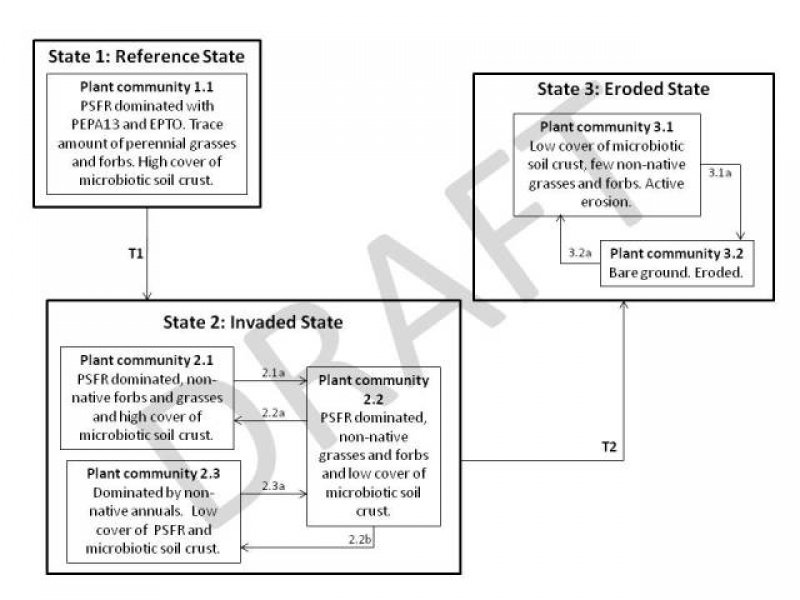
State and transition model
More interactive model formats are also available.
View Interactive Models
More interactive model formats are also available.
View Interactive Models
Click on state and transition labels to scroll to the respective text
Ecosystem states
State 1 submodel, plant communities
State 2 submodel, plant communities
State 3 submodel, plant communities
State 1
Reference State
This state represents the natural range of variability under pristine conditions. Primary natural disturbance mechanisms affecting this ecological site are long-term drought and insect attack. Historically, this state experienced an extended fire return interval, which resulted in long-lived stable plant communities. These communities were sparsely vegetated, therefore soil stability was primarily provided by microbiotic soil crust.
Community 1.1
Reference Plant Community
The reference plant community is dominated by Fremont dalea. Fourwing saltbush, Parry's sandpaper plant, and white bursage are other important species Potential vegetative composition is about 10% perennial grasses, 5% forbs and 85% shrubs. Approximate ground cover (basal and crown) is less than 15 percent (˜13%).
Figure 2. Annual production by plant type (representative values) or group (midpoint values)
Table 5. Annual production by plant type
| Plant type | Low (lb/acre) |
Representative value (lb/acre) |
High (lb/acre) |
|---|---|---|---|
| Shrub/Vine | 85 | 128 | 213 |
| Grass/Grasslike | 10 | 15 | 25 |
| Forb | 5 | 7 | 12 |
| Total | 100 | 150 | 250 |
State 2
Invaded
The Invaded State is characterized by the presence of non-natives in the understory. A biotic threshold has been crossed with the introduction of non-native annuals that cannot be removed from the system. Ecological resiliency has been reduced by the presence of non-native annual species that have the potential to alter disturbance regimes significantly from their natural or historic range of disturbances alter disturbance regimes significantly from their natural or historic range of variability. Introduced annuals such as red brome, schismus and redstem stork's bill have invaded the reference plant community and have become a dominant component of the herbaceous cover. The invasion of non-natives is attributed to a combination of factors including: 1) surface disturbances, 2) changes in the kinds of animals and their grazing patterns, 3) drought, and 4) changes in fire history. These non-natives annuals are highly flammable and promote wildfires where fires historically have been infrequent.
Community 2.1
Plant Community Phase 2.1
The plant composition is similar to the Reference Plant Community. In the absence of disturbance, ecological processes of this plant community have not been compromised by the presence of non-native species. PSFR and ATCA2 persist after invasion by non-native annuals, but other shrubs and desirable grasses may be unsuccessful in competing with the non-natives.
Community 2.2
Plant Community Phase 2.2
This plant community is characterized by reduced cover of microbiotic crust. Disturbances causing soil trampling removes microbiotic soil crust decreasing the stability of the site. Woody perennials persist through increased disturbance, however, native forbs and grasses experience decreased vigor and reproductive capacity. Non-native species remain in the understory.
Community 2.3
Plant Community Phase 2.3
This plant community is characterized by the loss of deep-rooted perennial vegetation. The soil surface is continually disturbed decreasing the cover of microbiotic crust. Non-native annuals take advantage of the increased available resources. This plant community is identified as “at risk”. The loss of microbiotic soil crust and perennial vegetative cover has reduced the ecological resistance and resilience. Management of this plant community should be focused on removing disturbances and protecting remnants of native vegetation.
Pathway 2.1a
Community 2.1 to 2.2
Anthropogenic disturbances disturb microbiotic soil crust reducing stability of the site.
Pathway 2.2a
Community 2.2 to 2.1
Management decisions that decrease disturbance over the long term allow microbiotic crust to recover.
Pathway 2.2b
Community 2.2 to 2.3
Continued disturbance removes Fremont’s dalea and other shrubby vegetation. Non-native annuals increase and microbiotic crusts are unable to recover.
Pathway 2.3a
Community 2.3 to 2.2
With time Fremont’s dalea reestablishes from seed.
State 3
Eroded State
The Eroded State is characterized by reduced soil stabilization due to loss of vegetative cover and microbiotic soil crust. A biotic threshold has been crossed, with the loss of microbiotic soil crust leading to active soil erosion. This state is characterized by a new ecological equilibrium, one that includes reduced nutrient cycling and infiltration.
Community 3.1
Plant Community Phase 3.1
Vegetation is dominated by non-native annuals. Soil stability is severely reduced. Active erosion easily occurs, including down cutting and the relocation of soil down slope, even during typical rainfall events.
Community 3.2
Plant Community Phase 3.2
This plant community is characterized by total loss of perennial vegetation and microbiotic soil crust. Gullies and rills are common to severe. Ecological processes have been greatly altered.
Pathway 3.1a
Community 3.1 to 3.2
Continued disturbance or large rainfall event increases the level of erosion.
Pathway 3.2a
Community 3.2 to 3.1
Non-native annuals germinate and establish even on a severely eroded site.
Transition 1
State 1 to 2
Introduction of non-natives due to anthropogenic impacts, including OHV use, dry land farming, grazing, linear corridors, mining, military training operations and settlements.
Transition 2
State 2 to 3
Severe and continuous disturbance and/or long term drought decreases microbiotic soil crust and vegetative cover.
Additional community tables
Table 6. Community 1.1 plant community composition
| Group | Common name | Symbol | Scientific name | Annual production (lb/acre) | Foliar cover (%) | |
|---|---|---|---|---|---|---|
|
Grass/Grasslike
|
||||||
| 1 | Primary Perennial Grasses | 3–15 | ||||
| big galleta | PLRI3 | Pleuraphis rigida | 3–15 | – | ||
| 2 | Secondary Perennial Grasses | 1–8 | ||||
| Indian ricegrass | ACHY | Achnatherum hymenoides | 1–5 | – | ||
| purple threeawn | ARPU9 | Aristida purpurea | 1–5 | – | ||
|
Forb
|
||||||
| 3 | Perennial Forbs | 1–12 | ||||
| desert globemallow | SPAM2 | Sphaeralcea ambigua | 1–5 | – | ||
| 4 | Annual Forbs | 1–8 | ||||
|
Shrub/Vine
|
||||||
| 5 | Primary Shrubs | 73–153 | ||||
| Fremont's dalea | PSFR | Psorothamnus fremontii | 45–60 | – | ||
| Parry's sandpaper plant | PEPA13 | Petalonyx parryi | 8–23 | – | ||
| burrobush | AMDU2 | Ambrosia dumosa | 8–23 | – | ||
| fourwing saltbush | ATCA2 | Atriplex canescens | 8–23 | – | ||
| Torrey's jointfir | EPTO | Ephedra torreyana | 1–12 | – | ||
| catclaw acacia | ACGR | Acacia greggii | 3–12 | – | ||
| 6 | Secondary Shrubs | 1–23 | ||||
| ratany | KRAME | Krameria | 2–8 | – | ||
| creosote bush | LATR2 | Larrea tridentata | 2–8 | – | ||
| Palmer's crinklemat | TIPA | Tiquilia palmeri | 2–8 | – | ||
Interpretations
Animal community
Livestock Interpretations:
This site has limited value for livestock grazing, due to the low forage production. Big galleta is a coarse, nearly woody perennial bunchgrass that is considered to have only fair forage value for cattle and horses. Fourwing saltbush is adapted to browsing, and may show compensatory growth after stem removal. Old crown wood can produce vigorous sprouts after new growth is browsed; however, plants decline when subjected to overuse. White bursage is of intermediate forage value. It is fair to good forage for horses and fair to poor for cattle and sheep. However, because there is often little other forage where white bursage grows, it is often highly valuable to browsing animals and is sensitive to browsing. Catclaw is typically grazed in the spring or when new growth is available, but animal densities and availability of other forage also affect livestock use of catclaw. Utilization of catclaw is typically restricted to spring when young twigs and leaves are available. Catclaw is able to withstand heavy grazing pressure. Torrey’s ephedra is important winter forage for cattle and sheep.
Stocking rates vary over time depending upon season of use, climate variations, site, and previous and current management goals. A safe starting stocking rate is an estimated stocking rate that is fine tuned by the client by adaptive management through the year and from year to year.
Wildlife Interpretations:
Fourwing saltbush provides valuable habitat and year-round browse for wildlife. Fourwing saltbush also provides browse and shelter for small mammals. Additionally, the browse provides a source of water for black-tailed jackrabbits in arid environments. Granivorous birds consume the fruits. Wild ungulates, rodent and lagomorphs readily consume all aboveground portions of the plant. Palatability is rated good for deer, elk, pronghorn and bighorn sheep. White bursage is an important browse species for wildlife.
Hydrological functions
Runoff is very low. Permeability is moderately rapid. Hydrologic soil group is D.
Other products
Fourwing saltbush is traditionally important to Native Americans. They ground the seeds for flour. The leaves, placed on coals, impart a salty flavor to corn and other roasted food. Top-growth produces a yellow dye. Young leaves and shoots were used to dye wool and other materials. The roots and flowers were ground to soothe insect bites. White bursage is a host for sandfood, a parasitic plant with a sweet, succulent, subterranean flowerstalk. Sandfood was a valuable food supply for desert peoples.
Other information
Fourwing saltbush is widely used in rangeland and riparian improvement and reclamation projects, including burned area recovery. It is probably the most widely used shrub for restoration of winter ranges and mined land reclamation. White bursage may be used to revegetate disturbed sites in southwestern deserts. Big galleta's clumped growth form stabilizes blowing sand.
Supporting information
Type locality
| Location 1: Clark County, NV | |
|---|---|
| Township/Range/Section | T17S R68E S17 |
| UTM zone | N |
| UTM northing | 4036831 |
| UTM easting | 731152 |
| Latitude | 36° 26′ 56″ |
| Longitude | 114° 25′ 15″ |
| General legal description | SW1/4 Section 17, T17S. R68E. MDBM. Lake Mead National Recreation Area about 3.5 miles west of Overton Beach and the Overton Arm of Lake Mead. Clark County, Nevada. |
Other references
Belnap, J. 1995. Surface Disturbances: Their role in accelerating desertification. Environmental Monitoring and Assessment. 37: 39-57.
Dong, H., J.A. Rech, H. Jiang, H. Sun and B.J. Buck. 2007. Endolithic cyanobacteria in soil gypsum: Occurrences in Atacama (Chile), Mojave (United State) and Al-Jafr Basin (Jordan) Deserts. J. of Geophysical Research. 112: 1-11.
Eskew, D.L. and I.P. Ting. 1978. Nitrogen fixation by legumes and blue-green algal-lichen crust in a Colorado Desert environment. Am. J. Bot. 65: 850-856.
FAO Soils Bulletin 62. 1990. Management of Gypsiferous Soils. Food and Agriculture Organization of the United Nations. Rome.
Fire Effects Information System (Online; http://www.fs.fed.us/database/feis/plants/).
USDA-NRCS Plants Database (Online; http://www.plants.usda.gov).
Contributors
CJT/GKB
Approval
Sarah Quistberg, 2/26/2025
Rangeland health reference sheet
Interpreting Indicators of Rangeland Health is a qualitative assessment protocol used to determine ecosystem condition based on benchmark characteristics described in the Reference Sheet. A suite of 17 (or more) indicators are typically considered in an assessment. The ecological site(s) representative of an assessment location must be known prior to applying the protocol and must be verified based on soils and climate. Current plant community cannot be used to identify the ecological site.
| Author(s)/participant(s) | P Novak-Echenique |
|---|---|
| Contact for lead author | State Rangeland Management Specialist |
| Date | 06/17/2010 |
| Approved by | Sarah Quistberg |
| Approval date | |
| Composition (Indicators 10 and 12) based on | Annual Production |
Indicators
-
Number and extent of rills:
Rills are none. -
Presence of water flow patterns:
Water flow patterns are none. -
Number and height of erosional pedestals or terracettes:
Pedestals are rare with occurrence typically limited to areas of wind-scouring. -
Bare ground from Ecological Site Description or other studies (rock, litter, lichen, moss, plant canopy are not bare ground):
Bare Ground 70-80%; shrub canopy to 15%; basal area for perennial herbaceous plants trace. -
Number of gullies and erosion associated with gullies:
None -
Extent of wind scoured, blowouts and/or depositional areas:
A small amount of wind-scouring can be expected. -
Amount of litter movement (describe size and distance expected to travel):
Fine litter (foliage from grasses and annual & perennial forbs) expected to move distance of slope length during intense summer convection storms or rapid snowmelt events. Persistent litter (large woody material) will remain in place except during catastrophic events. -
Soil surface (top few mm) resistance to erosion (stability values are averages - most sites will show a range of values):
Soil stability values should be 1 to 3 on the coarse soil textures found on this site. (To be field tested.) -
Soil surface structure and SOM content (include type of structure and A-horizon color and thickness):
Surface soil structure is typically moderate medium platy. Soil surface colors are light and soils are typified by an ochric epipedon. Organic matter of the surface 2 to 3 inches is less than 1 percent. -
Effect of community phase composition (relative proportion of different functional groups) and spatial distribution on infiltration and runoff:
Sparse shrub canopy and associated litter break raindrop impact. -
Presence and thickness of compaction layer (usually none; describe soil profile features which may be mistaken for compaction on this site):
None. Platy or massive sub-surface horizons or gypsic horizons are not to be interpreted as compacted layers. -
Functional/Structural Groups (list in order of descending dominance by above-ground annual-production or live foliar cover using symbols: >>, >, = to indicate much greater than, greater than, and equal to):
Dominant:
Mojave Desert shrubsSub-dominant:
perennial bunchgrasses > perennial forbs > annual grasses = annual forbsOther:
Additional:
-
Amount of plant mortality and decadence (include which functional groups are expected to show mortality or decadence):
Dead branches within individual shrubs common and standing dead shrub canopy material may be as much as 25% of total woody canopy; mature bunchgrasses commonly (±15%) have dead centers. -
Average percent litter cover (%) and depth ( in):
Between plant interspaces (Trace). -
Expected annual annual-production (this is TOTAL above-ground annual-production, not just forage annual-production):
For normal or average growing season ±150lbs/ac. -
Potential invasive (including noxious) species (native and non-native). List species which BOTH characterize degraded states and have the potential to become a dominant or co-dominant species on the ecological site if their future establishment and growth is not actively controlled by management interventions. Species that become dominant for only one to several years (e.g., short-term response to drought or wildfire) are not invasive plants. Note that unlike other indicators, we are describing what is NOT expected in the reference state for the ecological site:
Invaders on this site include annuals such as red brome, filaree and Mediterranean grass. -
Perennial plant reproductive capability:
All functional groups should reproduce in average growing season years.
Print Options
Sections
Font
Other
The Ecosystem Dynamics Interpretive Tool is an information system framework developed by the USDA-ARS Jornada Experimental Range, USDA Natural Resources Conservation Service, and New Mexico State University.
Click on box and path labels to scroll to the respective text.