Natural Resources
Conservation Service
Ecological site R030XC027NV
SHALLOW GRAVELLY SANDSTONE 7-9 P.Z.
Last updated: 2/25/2025
Accessed: 05/10/2025
General information
Provisional. A provisional ecological site description has undergone quality control and quality assurance review. It contains a working state and transition model and enough information to identify the ecological site.
Ecological site concept
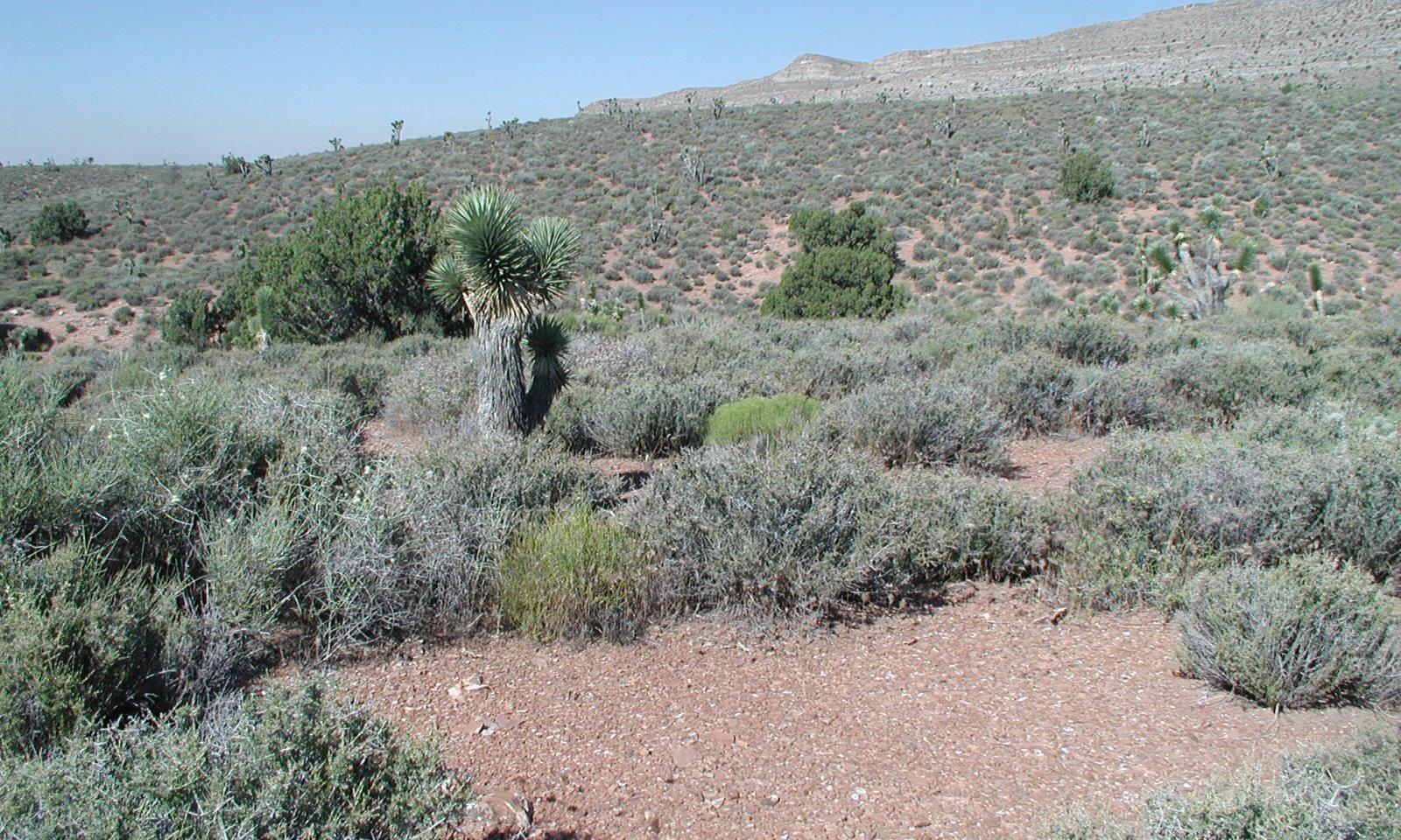
This site occurs on mountains and foothill slopes and have slopes of 8 to 50 percent. Elevations range from 4000 to 7000 feet. The soils associated with this site are very shallow, well drained soils that formed in residuum and colluvium from calcareous sandstone and siltstone.
Associated sites
| R030XC007NV |
SHALLOW GRAVELLY LOAM 7-9 P.Z. Found on limestone parent material. |
|---|
Similar sites
| R030XC025NV |
SHALLOW LIMESTONE SLOPE 11-13 P.Z. On mountain slopes, blackbrush minor component. |
|---|---|
| R030XC007NV |
SHALLOW GRAVELLY LOAM 7-9 P.Z. Similar site, less spiny menadora, found on limestone parent material. |
| R030XC018NV |
SHALLOW GRAVELLY SLOPE 11-13 P.Z. More productive site, ustic soils. |
Table 1. Dominant plant species
| Tree |
Not specified |
|---|---|
| Shrub |
(1) Coleogyne ramosissima |
| Herbaceous |
(1) Achnatherum speciosum |
Physiographic features
This site occurs on mountains and foothill slopes and have slopes of 8 to 50 percent. Elevations range from 4000 to 7000 feet.
Table 2. Representative physiographic features
| Landforms |
(1)
Mountain
(2) Hill (3) Mountain slope |
|---|---|
| Elevation | 4,000 – 7,000 ft |
| Slope | 8 – 50% |
| Aspect | Aspect is not a significant factor |
Climatic features
The primary air masses affecting the Spring Mountains are cold maritime polar air from the Gulf of Alaska and warmer, moist maritime subtropical air from lower latitudes. Occasionally there are invasions of cold continental polar air from northern Canada or the Rocky Mountains. Precipitation in the area results primarily from the passage of cyclones with associated fronts during fall, winter and spring; from closed cyclones in late winter and spring; and from the flow of moist tropical air from the southeast to the southwest quadrant in the summer.
The mean annual precipitation is about 7 to 9 inches and mean annual air temperature is 51 to 56 degrees F., and the frost-free season is 130 to 180 days. There are no climate stations associated with this site.
Table 3. Representative climatic features
| Frost-free period (average) | 180 days |
|---|---|
| Freeze-free period (average) | |
| Precipitation total (average) | 9 in |
Influencing water features
There are no influencing water features associated with this site.
Soil features
The soils associated with this site are very shallow, well drained soils that formed in residuum and colluvium from calcareous sandstone and siltstone. Available water capacity is very low. Infiltration is rapid and permeability is moderate. The surface has approximately 60 to 80 percent pebbles or channers, 2 percent cobbles and 1 percent stones. The soils are usually dry. They are moist in some part for short periods during winter and early spring and for 10 to 20 days cumulative between July to October following convection storms. Soils have a typic-aridic moisture regime. Soil series associated with site include Moentria.
Table 4. Representative soil features
| Surface texture |
(1) Extremely gravelly loam |
|---|---|
| Family particle size |
(1) Loamy |
| Drainage class | Well drained |
| Permeability class | Moderate |
| Soil depth | 10 – 20 in |
| Surface fragment cover <=3" | 60 – 80% |
| Surface fragment cover >3" | 1 – 5% |
| Available water capacity (0-40in) |
0.5 – 0.7 in |
| Calcium carbonate equivalent (0-40in) |
15 – 40% |
| Electrical conductivity (0-40in) |
4 mmhos/cm |
| Sodium adsorption ratio (0-40in) |
1 – 12 |
| Soil reaction (1:1 water) (0-40in) |
7.9 – 8.4 |
| Subsurface fragment volume <=3" (Depth not specified) |
46 – 70% |
| Subsurface fragment volume >3" (Depth not specified) |
2 – 3% |
Ecological dynamics
Shrubs are tyically evenaged with few seedlings or young plants. Where fire occurs it will typically removed the the blackbrush community and a big sagebrush community typically replaces it for a protracted period. Purple threeawn will often dominate the understory in this situation. Where management results in abusive grazing use by livestock and/or feral horses, cool-season perennial grasses decrease as blackbrush becomes more dominant. With severe disturbance broom snakeweed, red brome and cheatgrass become prevalent.
Fire Ecology:
Low amounts of fine fuels in interspaces probably limited fire spread in blackbrush communities to only extreme fire conditions, during which high winds, low relative humidity, and low fuel moisture led to high intensity stand-replacing crown fires. Historical fire return intervals appear to have been on the order of centuries, allowing late seral blackbrush stands to reestablish. Blackbrush stands are subject to fire, and fire will start and spread easily due to the dense, close spacing nature and resinous foliage of blackbrush. Blackbrush is slow to reestablish. It is generally removed from the site. Most perennial grasses have root crowns that can survive wildfire. Desert needlegrass has persistent dead leaf bases, which make it susceptible to burning. Fire removes the accumulation; a rapid, cool fire will not burn deep into the root crown.
State and transition model
More interactive model formats are also available.
View Interactive Models
Click on state and transition labels to scroll to the respective text
Ecosystem states
State 1 submodel, plant communities
State 1
Reference Blackbrush/Spiny menodora
Potential vegetative composition is about 20 percent grasses, 5 percent forbs and 70 percent shrubs and up to 5 percent trees.
Community 1.1
Reference Plant Community

The reference plant community is dominated by blackbrush. Spiny menodora, Nevada ephedra, and desert needlegrass are important species associated with this site. Potential vegetative composistion is about 20 percent grasses, 5 percent forbs and 70 percent shrubs and up to 5 percent trees. Approximate ground cover (basal and crown) is about 20 to 30 percent. Total annual air-dry production is 700 pounds favorable years, 500 pounds normal years, and 300 pounds on unfavorable years.
Figure 1. Annual production by plant type (representative values) or group (midpoint values)
Table 5. Annual production by plant type
| Plant type | Low (lb/acre) |
Representative value (lb/acre) |
High (lb/acre) |
|---|---|---|---|
| Shrub/Vine | 224 | 362 | 500 |
| Grass/Grasslike | 60 | 100 | 140 |
| Forb | 15 | 25 | 35 |
| Tree | 1 | 13 | 25 |
| Total | 300 | 500 | 700 |
Table 6. Ground cover
| Tree foliar cover | 0-5% |
|---|---|
| Shrub/vine/liana foliar cover | 20-30% |
| Grass/grasslike foliar cover | 1-5% |
| Forb foliar cover | 1-5% |
| Non-vascular plants | 0% |
| Biological crusts | 0% |
| Litter | 1-5% |
| Surface fragments >0.25" and <=3" | 60-80% |
| Surface fragments >3" | 1-5% |
| Bedrock | 0% |
| Water | 0% |
| Bare ground | 10-20% |
Table 7. Canopy structure (% cover)
| Height Above Ground (ft) | Tree | Shrub/Vine | Grass/ Grasslike |
Forb |
|---|---|---|---|---|
| <0.5 | 1-2% | 1-5% | 1-2% | 1-5% |
| >0.5 <= 1 | 1-2% | 1-5% | 1-2% | 1-5% |
| >1 <= 2 | 1-2% | 10-20% | 1-5% | – |
| >2 <= 4.5 | 1-5% | 20-30% | – | – |
| >4.5 <= 13 | 1-5% | – | – | – |
| >13 <= 40 | – | – | – | – |
| >40 <= 80 | – | – | – | – |
| >80 <= 120 | – | – | – | – |
| >120 | – | – | – | – |
State 2
Degraded
With severe disturbance broom snakeweed, red brome and cheatgrass become prevalent.
Transition T1A
State 1 to 2
Where management results in abusive grazing use by livestock and/or feral horses, cool-season perennial grasses decrease as blackbrush becomes more dominant. With severe disturbance broom snakeweed, red brome and cheatgrass become prevalent.
Restoration pathway R2A
State 2 to 1
A slow rebuilding of soil organic matter and a recolonization of shrubs and perennial grasses. Once cheatgrass brome is introduced the site it may always be a part of the community.
Additional community tables
Table 8. Community 1.1 plant community composition
| Group | Common name | Symbol | Scientific name | Annual production (lb/acre) | Foliar cover (%) | |
|---|---|---|---|---|---|---|
|
Grass/Grasslike
|
||||||
| 1 | Primary Perennial Grasses | 25–75 | ||||
| desert needlegrass | ACSP12 | Achnatherum speciosum | 25–75 | – | ||
| 2 | Secondary Perennial Grasses | 25–50 | ||||
| Indian ricegrass | ACHY | Achnatherum hymenoides | 3–15 | – | ||
| purple threeawn | ARPU9 | Aristida purpurea | 3–15 | – | ||
|
Forb
|
||||||
| 3 | Primary Perennial Forbs | 10–25 | ||||
| desert globemallow | SPAM2 | Sphaeralcea ambigua | 10–25 | – | ||
| 4 | Secondary Perennial Forbs | 1–25 | ||||
| mariposa lily | CALOC | Calochortus | 3–10 | – | ||
| Indian paintbrush | CASTI2 | Castilleja | 3–10 | – | ||
| cryptantha | CRYPT | Cryptantha | 3–10 | – | ||
| desert larkspur | DEPA | Delphinium parishii | 3–10 | – | ||
| Lewis flax | LILE3 | Linum lewisii | 3–10 | – | ||
| Fremont's phacelia | PHFR2 | Phacelia fremontii | 3–10 | – | ||
| desert princesplume | STPI | Stanleya pinnata | 3–10 | – | ||
|
Shrub/Vine
|
||||||
| 5 | Primary Shrubs | 200–375 | ||||
| blackbrush | CORA | Coleogyne ramosissima | 150–275 | – | ||
| spiny menodora | MESP2 | Menodora spinescens | 50–100 | – | ||
| 6 | Secondary Shrubs | 25–50 | ||||
| fourwing saltbush | ATCA2 | Atriplex canescens | 5–10 | – | ||
| Virgin River brittlebush | ENVI | Encelia virginensis | 5–10 | – | ||
| Nevada jointfir | EPNE | Ephedra nevadensis | 5–10 | – | ||
| mormon tea | EPVI | Ephedra viridis | 5–10 | – | ||
| winterfat | KRLA2 | Krascheninnikovia lanata | 5–10 | – | ||
| desert pepperweed | LEFR2 | Lepidium fremontii | 5–10 | – | ||
| water jacket | LYAN | Lycium andersonii | 5–10 | – | ||
| Mexican bladdersage | SAME | Salazaria mexicana | 5–10 | – | ||
| shortspine horsebrush | TESP2 | Tetradymia spinosa | 5–10 | – | ||
| turpentinebroom | THMO | Thamnosma montana | 5–10 | – | ||
| banana yucca | YUBA | Yucca baccata | 5–10 | – | ||
| Joshua tree | YUBR | Yucca brevifolia | 5–10 | – | ||
|
Tree
|
||||||
| 7 | Trees | 1–25 | ||||
| Utah juniper | JUOS | Juniperus osteosperma | 1–25 | – | ||
Interpretations
Animal community
Livestock Interpretations:
This site has limited value for livestock grazing, due to the low forage production. Grazing management should be keyed to perennial grasses or palatable shrubs production. Blackbrush is not preferred as forage by domestic livestock, but does provide some forage during the spring, summer and fall. Spiny menodora has lower palatability than the other shrubs but is consumed during early spring before spines mature. Young desert needlegrass is palatable to all classes of livestock. Mature herbage is moderately grazed by horses and cattle, but rarely grazed by sheep.
Stocking rates vary over time depending upon season of use, climate variations, site, and previous and current management goals. A safe starting stocking rate is an estimated stocking rate that is fine tuned by the client by adaptive management through the year and from year to year.
Wildlife Interpretations:
Blackbrush is a valuable browse species for bighorn sheep. It may also comprise up to 25% of the mule deer winter diet. Blackbrush provides cover for upland game birds, nongame birds and small mammals. Spiny menodora has lower palatability than the other shrubs but is consumed during early spring before spines mature. Young desert needlegrass is palatable to many species of wildlife. Desert needlegrass produces considerable basal foliage and is good forage while young. Desert bighorn sheep graze desert needlegrass.
Hydrological functions
Rills - Rills are rare and are more likely to appear on steeper slopes.
Water flow Patterns – Are few and are found in interspaces between shrubs, not connected.
Pedestals and/or Terracettes – Few to none. High cover of rock fragements limits pedestal development.
Bare Ground – 5 to 20 percent. Soil surface is mostly covered by gravels and vegetation.
Gullies – None
Wind-Scoured, Blowouts, and/or Deposition Areas – No wind-scoured or blow out areas due to high gravel cover. Small depositional areas found up slope of grasses and large shrubs.
Litter Movement – 1 inch or less in size from water or wind.
Soil Surface Resistance to Erosion – Soil surface resistante due to high amounts of gravels and vegetation cover and litter. Stability values be 3-5 (not tested).
Soil Surface Loss or Degradation – Soils have low organic matter. “A” horizon averages 3 inch depth with 1-2% organic material.
Plant Community Composition and Distribution Relative to Infiltration and Runoff – Plant community composition is approximately 20 percent herbaceous and 80 percent shrubs production with 20 to 30 percent ground cover. Soils have moderate permeability.
Compaction Layer – None. Weathered bedrock at 10 to 20 inches.
Recreational uses
This site is suitable for recreational uses such as hiking, birdwatching and hunting.
Other information
Blackbrush contributes to desert fertility by 1) protecting the soil against wind erosion through retarding the movement of soil and increasing the accumulation of fine soil particles around its base; 2) protecting understory vegetation from the effects of high temperatures, thereby helping to retain surface nitrogen and adding organic matter to the soil; and 3) serving as a nitrogen reservoir through the storage of nitrogen in roots, leaves, and stems.
Desert needlegrass seeds are easily germinated and have potential for commercial use. Desert needlegrass may be used for groundcover in areas of light disturbance, but it is susceptible to excessive trampling.
There is one known plant species of concern found in this ecological site in the Spring Mountain National Recreation Area (SMNRA).
Supporting information
Type locality
| Location 1: Clark County, NV | |
|---|---|
| Township/Range/Section | T22 S R57 E S14SE |
| UTM zone | N |
| UTM northing | 3988587n |
| UTM easting | 0629920n |
| General legal description | Approximately 1 mile north on Lovell Canyon road from Highway 160, Clark County, Nevada. |
Other references
Clokey, Ira. 1951. Flora of the Charleston Mountains, Clark County, Nevada. University of California Press, Berkeley and Los Angeles.
Fire Effects Information System [Online]. http://www.fs.fed.us/feis.
Glenne, G., Johnson, D. 2002. Guide to Species of Concern in the Spring Mountains National Recreation Area, Clark and Nye Counties, Nevada. USFS, Las Vegas, NV.
Nachlinger, J., G. Reese. 1996. Plant Community Classification of the Spring Mountains National Recreation Area, Clark and Nye Counties, Nevada. The Nature Conservancy. Reno, Nevada.
Contributors
TJW
Approval
Sarah Quistberg, 2/25/2025
Rangeland health reference sheet
Interpreting Indicators of Rangeland Health is a qualitative assessment protocol used to determine ecosystem condition based on benchmark characteristics described in the Reference Sheet. A suite of 17 (or more) indicators are typically considered in an assessment. The ecological site(s) representative of an assessment location must be known prior to applying the protocol and must be verified based on soils and climate. Current plant community cannot be used to identify the ecological site.
| Author(s)/participant(s) | |
|---|---|
| Contact for lead author | |
| Date | 02/26/2025 |
| Approved by | Sarah Quistberg |
| Approval date | |
| Composition (Indicators 10 and 12) based on | Annual Production |
Indicators
-
Number and extent of rills:
-
Presence of water flow patterns:
-
Number and height of erosional pedestals or terracettes:
-
Bare ground from Ecological Site Description or other studies (rock, litter, lichen, moss, plant canopy are not bare ground):
-
Number of gullies and erosion associated with gullies:
-
Extent of wind scoured, blowouts and/or depositional areas:
-
Amount of litter movement (describe size and distance expected to travel):
-
Soil surface (top few mm) resistance to erosion (stability values are averages - most sites will show a range of values):
-
Soil surface structure and SOM content (include type of structure and A-horizon color and thickness):
-
Effect of community phase composition (relative proportion of different functional groups) and spatial distribution on infiltration and runoff:
-
Presence and thickness of compaction layer (usually none; describe soil profile features which may be mistaken for compaction on this site):
-
Functional/Structural Groups (list in order of descending dominance by above-ground annual-production or live foliar cover using symbols: >>, >, = to indicate much greater than, greater than, and equal to):
Dominant:
Sub-dominant:
Other:
Additional:
-
Amount of plant mortality and decadence (include which functional groups are expected to show mortality or decadence):
-
Average percent litter cover (%) and depth ( in):
-
Expected annual annual-production (this is TOTAL above-ground annual-production, not just forage annual-production):
-
Potential invasive (including noxious) species (native and non-native). List species which BOTH characterize degraded states and have the potential to become a dominant or co-dominant species on the ecological site if their future establishment and growth is not actively controlled by management interventions. Species that become dominant for only one to several years (e.g., short-term response to drought or wildfire) are not invasive plants. Note that unlike other indicators, we are describing what is NOT expected in the reference state for the ecological site:
-
Perennial plant reproductive capability:
Print Options
Sections
Font
Other
The Ecosystem Dynamics Interpretive Tool is an information system framework developed by the USDA-ARS Jornada Experimental Range, USDA Natural Resources Conservation Service, and New Mexico State University.
Click on box and path labels to scroll to the respective text.