Natural Resources
Conservation Service
Ecological site R030XC030NV
MOUNTAIN RIDGE
Last updated: 2/25/2025
Accessed: 05/11/2025
General information
Provisional. A provisional ecological site description has undergone quality control and quality assurance review. It contains a working state and transition model and enough information to identify the ecological site.
Ecological site concept
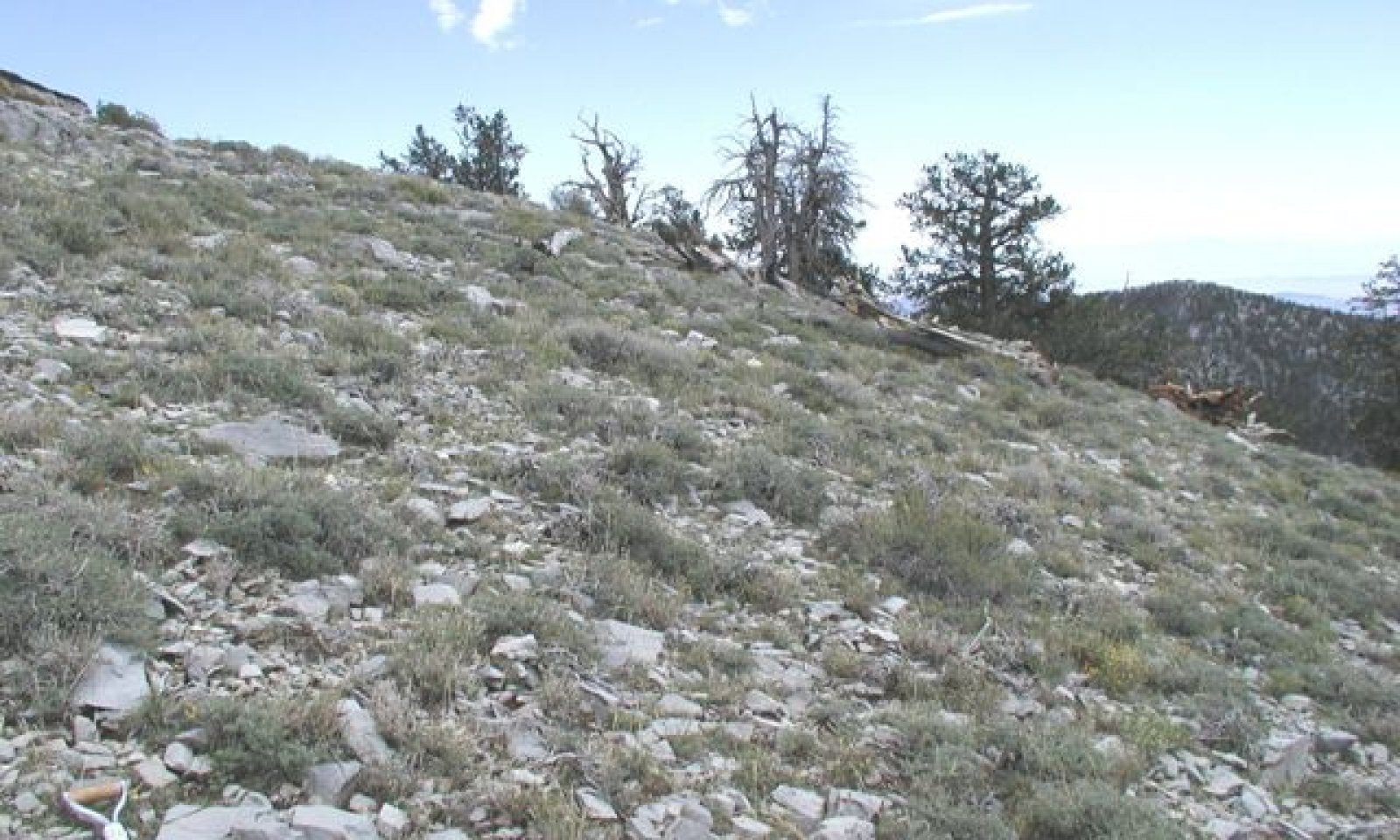
This site occurs on high windswept ridges and shoulders of mountains. Slopes range from 8 to 75 percent, but slopes of 15 to 50 percent are most typical. Elevations range from 9600 to 9933 feet. The soils associated with this site are very shallow to limestone bedrock, well drained and formed in residuum and colluvium from dolomite and limestone.
Associated sites
| F030XC290NV |
SOUTH-FACING LIMESTONE SLOPES |
|---|---|
| F030XC291NV |
NORTH-FACING LIMESTONE SLOPES |
Similar sites
| R030XC045NV |
SHALLOW NORTH SLOPE 9-11 P.Z. EPVI, BOGR2 important species. |
|---|
Table 1. Dominant plant species
| Tree |
Not specified |
|---|---|
| Shrub |
(1) Artemisia nova |
| Herbaceous |
(1) Poa fendleriana |
Physiographic features
This site occurs on high windswept ridges and shoulders of mountains. Slopes range from 8 to 75 percent, but slopes of 15 to 50 percent are most typical. Elevations range from 9600 to 9933 feet.
Table 2. Representative physiographic features
| Landforms |
(1)
Ridge
(2) Mountain slope |
|---|---|
| Flooding frequency | None |
| Ponding frequency | None |
| Elevation | 9,600 – 9,933 ft |
| Slope | 8 – 75% |
| Aspect | Aspect is not a significant factor |
Climatic features
The climate associated with this site is subalpine with cool summers and cold winters. Intense winds over this site inhibit snow accumulation and thus lower the effective precipitation. Average annual precipitation is 14 to 17 inches. Mean annual air temperature is 37 to 46 degrees F. The average frost free season is 50 to 120 days.
Table 3. Representative climatic features
| Frost-free period (average) | 120 days |
|---|---|
| Freeze-free period (average) | |
| Precipitation total (average) | 17 in |
Figure 1. Monthly precipitation range
Figure 2. Monthly average minimum and maximum temperature
Influencing water features
There are no influencing water features associated with this site.
Soil features
The soils associated with this site are very shallow to limestone bedrock, well drained and formed in residuum and colluvium from dolomite and limestone. Runoff is very high and infiltration is rapid. Soils are usually dry, but are moist for brief periods in the winter and early spring. A mollic epipedon occurs from 0 to 6 inches. The soils are classified as loamy-skeletal, mixed, superactive, frigid aridic Lithic Haplustolls.
Table 4. Representative soil features
| Parent material |
(1)
Residuum
–
limestone
(2) Colluvium – limestone |
|---|---|
| Surface texture |
(1) Extremely cobbly fine sandy loam |
| Family particle size |
(1) Loamy |
| Drainage class | Well drained |
| Permeability class | Moderate |
| Soil depth | 5 – 10 in |
| Surface fragment cover <=3" | 30 – 35% |
| Surface fragment cover >3" | 20 – 25% |
| Available water capacity (0-40in) |
0.59 – 1.61 in |
| Calcium carbonate equivalent (0-40in) |
30 – 50% |
| Electrical conductivity (0-40in) |
Not specified |
| Sodium adsorption ratio (0-40in) |
Not specified |
| Soil reaction (1:1 water) (0-40in) |
7.4 – 7.6 |
| Subsurface fragment volume <=3" (Depth not specified) |
20 – 50% |
| Subsurface fragment volume >3" (Depth not specified) |
10 – 25% |
Ecological dynamics
Subalpine communities are sensitive to disturbance and the effects of human disturbances are more drastic and long-lasting than in other plant communities. Vegetation recovery is slow because of the cold and extreme temperatures, high winds, prolonged snow cover, and intense ultraviolet radiation. Fire occurs very infrequently in subalpine communities and fire size is small, sometimes limited to a single tree.
The reference plant community is dominated by black sagebrush. Black sagebrush is common on shallow soils and windy ridges that are often swept free of snow in the winter (Fryer 2009). The shallow soils prevent deeper rooted trees species from invading this site, allowing black sagebrush to remain dominant. Black sagebrush is an evergreen, aromatic shrub that is low-growing and decumbent. Black sagebrush has a taproot and wide-spreading lateral roots. Roots can be deep on favorable sites, but shallow soils prevent deep root development on most sites where black sagebrush is dominant. Black sagebrush tends to have a larger number of fibrous roots than big sagebrush. Black sagebrush is highly drought tolerant; it is more likely to endure drought than most sagebrush taxa. It is slightly salt tolerant and flood intolerant. Black sagebrush occurs throughout the successional process, it is highly light tolerant and shade intolerant and commonly establishes on disturbed sites (Fryer 2009).
Black sagebrush establishes solely from seed. Seeds are dispersed too late in the fall to germinate; most seeds go dormant and overwinter in the soil. Typically seeds do not persist for more than one growing season in the soil seed bank. The majority of seed falls under or near the parent plant. Black sagebrush seedlings experience increased recruitment and establishment during years of increased annual precipitation. Growth and survival of seedlings is highly dependent on soil moisture levels before, during and following the year of germination.
Sagebrush species are generally long-lived, therefore it is not necessary for new individuals to recruit every year for perpetuation of the stand. Infrequent large recruitment events and simultaneous low, continuous recruitment is the foundation of population maintenance (Noy-Meir 1973). Mature properly functioning sagebrush communities have higher infiltration rates and lower sediment production, than degraded systems. Reoccurring disturbances, natural or anthropogenic, will result in decreased sagebrush cover and increased cover of disturbance tolerant shrubs and the potential introduction of non-natives. Loss of structural and functional groups effects ecosystem functioning and can result in soil loss. As erosion increaes, the potential for loss of soil surface organic matter increases, resulting in further degradation of soil structure.
Fire Ecology:
There are no records of historic fire frequencies or fire regimes for black sagebrush communities. Black sagebrush communities tend to occupy unproductive sites that have little fuel build-up, so fire was probably historically rare on many black sagebrush-dominated landscapes. Black sagebrush plants are readily killed by all fire intensities. Reestablishment of sagebrush occurs through wind-dispersed seed sources. Black sagebrush requires 15 to 60 years post fire to regain dominance. Since it may take several years for black sagebrush to establish and produce seed after fire, repeated, frequent fire can eliminate it from the site.
Muttongrass is unharmed to slightly harmed by light-severity fall fires. Muttongrass appears to be harmed by and slow to recover from severe fire. Blue grama has variable fire tolerance; it has fair tolerance when dormant but experiences some damage if burned during active growth, especially during drought. Fire generally favors blue grama, generally increasing its occurrence, production, and percent cover.
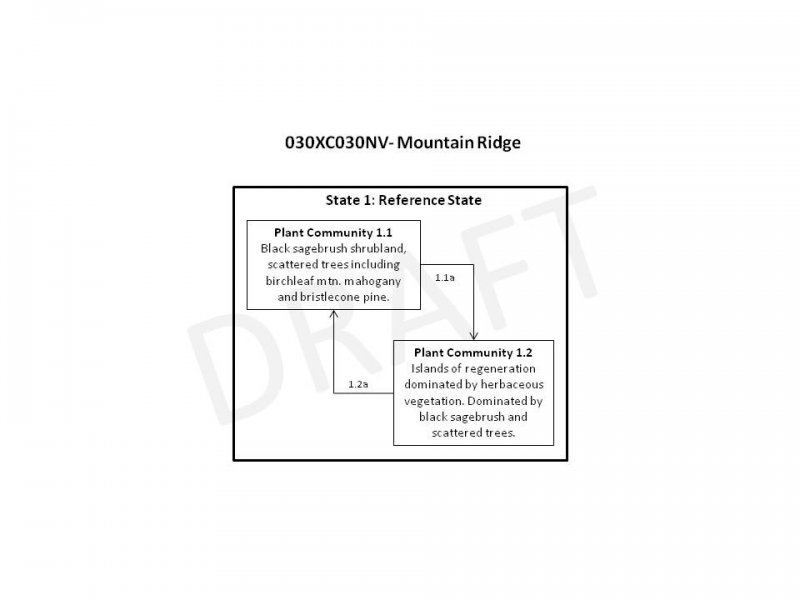
State and transition model
More interactive model formats are also available.
View Interactive Models
More interactive model formats are also available.
View Interactive Models
Click on state and transition labels to scroll to the respective text
Ecosystem states
State 1 submodel, plant communities
State 1
Reference State
The reference state is representative of the natural range of variability under pristine conditions. This state is dominated by long-lived evergreen shrub communities with an understory of cool and warm season perennial bunchgrasses. Plant community phase changes are primarily driven by small fires, long-term drought and insect attack. Historically, fire is rare in this system, but does impact long-term plant community dynamics. Subalpine communities are sensitive to disturbance. The effects of human disturbances are more drastic and long lasting than lower elevation plant communities. Vegetation recovery is slow because of the extreme temperatures, high winds, prolonged snow cover, short growing season and intense ultraviolet radiation. Currently this ecological site is described by a one-state model because additional states have not been identified on the landscape. For example, non-native plant species have not been identified on this ecological site. However, non-natives such as cheatgrass are capable of establishing in high elevation plant communities similar to this one. If in the future non-natives are found on this ecological site the state-and-transition model will be revised to include State 2: Invaded State.
Community 1.1
Reference Plant Community

Figure 3. Reference Plant Community
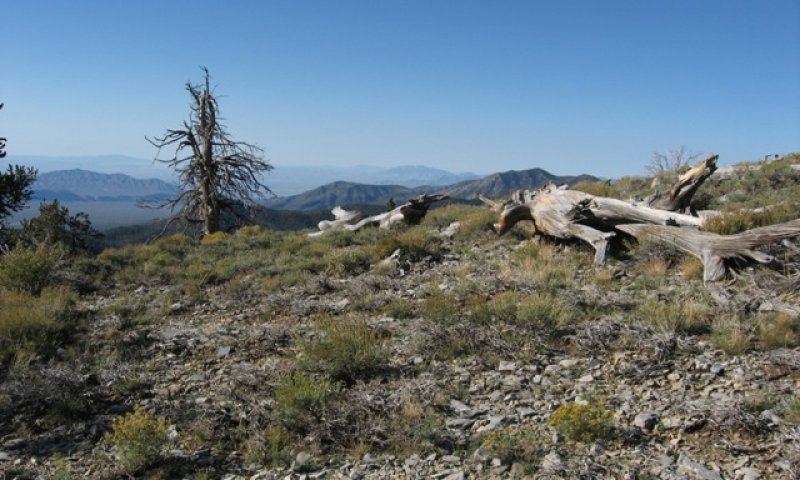
Figure 4. Burned bristlecone pine
The reference plant community is characteristic of a healthy, mid-seral plant community. It is dominated by black sagebrush, associated species included muttongrass and blue grama. Potential vegetative composition is about 20 percent grasses, 10 percent forbs, 70 percent shrubs and <1 percent trees. This plant community is long-lived, stable and rarely experiences large scale disturbance.
Figure 5. Annual production by plant type (representative values) or group (midpoint values)
Table 5. Annual production by plant type
| Plant type | Low (lb/acre) |
Representative value (lb/acre) |
High (lb/acre) |
|---|---|---|---|
| Shrub/Vine | 350 | 417 | 520 |
| Grass/Grasslike | 100 | 120 | 150 |
| Forb | 50 | 60 | 75 |
| Tree | 0 | 3 | 5 |
| Total | 500 | 600 | 750 |
Community 1.2
Plant community 1.2
This plant community is representative of a post-disturbance plant community. Small scale disturbances have removed patches of mature vegetation. Initially disturbed areas are dominated by herbaceous vegetation. Herbaceous vegetation benefits from the reduced competition, in both vigor and reproductive capacity. Sprouting shrubs recover quickly and provide protected sites for the establishment of shrub seedlings such as sagebrush.
Pathway 1.1a
Community 1.1 to 1.2
Wildfire, generally single tree fires resulting from lightning ignitions, prolonged drought, disease or insect attack.
Pathway 1.2a
Community 1.2 to 1.1
Absence from disturbance and natural regeneration over time.
Additional community tables
Table 6. Community 1.1 plant community composition
| Group | Common name | Symbol | Scientific name | Annual production (lb/acre) | Foliar cover (%) | |
|---|---|---|---|---|---|---|
|
Grass/Grasslike
|
||||||
| 1 | Primary Perennial Grasses | 72–120 | ||||
| muttongrass | POFE | Poa fendleriana | 60–90 | – | ||
| blue grama | BOGR2 | Bouteloua gracilis | 12–30 | – | ||
| 2 | Secondary Perennial Grasses | 1–30 | ||||
| squirreltail | ELEL5 | Elymus elymoides | 3–12 | – | ||
|
Forb
|
||||||
| 3 | Perennial Forbs | 30–60 | ||||
| Charleston sandwort | ARCOC2 | Arenaria congesta var. charlestonensis | 3–12 | – | ||
| milkvetch | ASTRA | Astragalus | 3–12 | – | ||
| wavyleaf Indian paintbrush | CAAPM | Castilleja applegatei ssp. martinii | 3–12 | – | ||
| Clokey's fleabane | ERCL | Erigeron clokeyi | 3–12 | – | ||
| Nuttall's linanthus | LENUN | Leptosiphon nuttallii ssp. nuttallii | 3–12 | – | ||
| Lewis flax | LILE3 | Linum lewisii | 3–12 | – | ||
| Thompson's beardtongue | PETH2 | Penstemon thompsoniae | 3–12 | – | ||
| Coville's phlox | PHCO12 | Phlox covillei | 3–12 | – | ||
|
Shrub/Vine
|
||||||
| 4 | Primary Shrubs | 330–390 | ||||
| black sagebrush | ARNO4 | Artemisia nova | 330–390 | – | ||
| 5 | Secondary Shrubs | 30–90 | ||||
| birchleaf mountain mahogany | CEMOG | Cercocarpus montanus var. glaber | 3–30 | – | ||
| desert sweet | CHMI2 | Chamaebatiaria millefolium | 3–30 | – | ||
| yellow rabbitbrush | CHVI8 | Chrysothamnus viscidiflorus | 3–30 | – | ||
| mormon tea | EPVI | Ephedra viridis | 3–30 | – | ||
| broom snakeweed | GUSA2 | Gutierrezia sarothrae | 3–30 | – | ||
| spineless horsebrush | TECA2 | Tetradymia canescens | 3–30 | – | ||
|
Tree
|
||||||
| 6 | Trees | 0–3 | ||||
| Rocky Mountain juniper | JUSC2 | Juniperus scopulorum | 0–2 | – | ||
| Great Basin bristlecone pine | PILO | Pinus longaeva | 0–2 | – | ||
Interpretations
Animal community
Livestock Interpretations:
This site has limited value for livestock grazing due to steep slopes and high elevations. Grazing management should be keyed to dominant grasses and palatable shrub production. Black sagebrush is a valuable browse plant for livestock. In winter, at lower elevations, black sagebrush is heavily utilized by domestic sheep. Cattle use of black sagebrush is greatest in fall and winter, with only trace amounts consumed in summer. Muttongrass is excellent forage for domestic livestock especially in the early spring. Muttongrass begins growth in late winter and early spring, which makes it available before many other forage plants. Blue grama is valuable forage for all classes of domestic livestock, providing excellent forage for cattle and sheep. Blue grama tends to be most productive following summer rains, but it cures well and provides forage year round.
Stocking rates vary over time depending upon season of use, climate variations, site, and previous and current management goals. A safe starting stocking rate is an estimated stocking rate that is fine tuned by the client by adaptive management through the year and from year to year.
Wildlife Interpretations:
Black sagebrush is a significant browse species within the Intermountain region. It is especially important on low elevation winter ranges in the southern Great Basin, where extended snow free periods allow animal’s access to plants throughout most of the winter. In these areas it is heavily utilized by bighorn sheep and mule deer. Deer heavily use muttongrass, especially in early spring when other green forage is scarce. Depending upon availability of other nutritious forage, deer may use muttongrass in all seasons. Muttongrass cures well and is an important fall and winter deer food in some areas. Blue grama also provides important forage for mule deer. Quail and some songbirds eat the seeds of blue grama. Small mammals also eat blue grama seeds and stems. Flower heads and seeds of blue grama are also consumed by grasshoppers, which can all but eliminate an annual seed crop.
Hydrological functions
Runoff is very high. Permeability is moderate.
Recreational uses
Aesthetic value is derived from the diverse floral and faunal composition and the colorful flowering of wild flowers and shrubs during the spring and early summer. This site offers rewarding opportunities to photographers and for nature study. This site is used for hiking and has potential for upland and big game hunting.
Other products
Black sagebrush stems, leaves, and twigs are traditionally used by Native Americans to treat bronchitis and nasal congestion.
Other information
Black sagebrush is an excellent species to establish on sites where management objectives include restoration or improvement of domestic sheep, pronghorn, or mule deer winter range. Because of its wide adaptation, ease of establishment, and economic value, blue grama is used extensively for conservation purposes, rangeland seeding, and landscaping. Blue grama is useful for reclamation and for erosion control in arid and semiarid regions.
Supporting information
Type locality
| Location 1: Clark County, NV | |
|---|---|
| Township/Range/Section | T15S R61E S4 |
| UTM zone | N |
| UTM northing | 4058378 |
| UTM easting | 666080 |
| Latitude | 36° 39′ 23″ |
| Longitude | 115° 8′ 30″ |
| General legal description | Section 4, T. 15S, R61E. Approximately 2 miles from the head of Sawmill Canyon in the Sheep Range of the Desert National Wildlife Refuge in Clark County, Nevada. USGS Hayford Peak, NV 7.5 minute topographic quadrangle. |
Other references
Fire Effects Information System (Online; http://www.fs.fed.us/database/feis/plants/).
Fryer, J. L. 2009. Artemisia nova. In: Fire Effects Information System, [Online]. U.S. Department of Agriculture, Forest Service, Rocky Mountain Research Station, Fire Sciences Laboratory (Producer). Available: http://www.fs.fed.us/database/feis/
USDA-NRCS Plants Database (Online; http://www.plants.usda.gov).
Contributors
E. Hourihan
P Novak-Echenique
Approval
Sarah Quistberg, 2/25/2025
Rangeland health reference sheet
Interpreting Indicators of Rangeland Health is a qualitative assessment protocol used to determine ecosystem condition based on benchmark characteristics described in the Reference Sheet. A suite of 17 (or more) indicators are typically considered in an assessment. The ecological site(s) representative of an assessment location must be known prior to applying the protocol and must be verified based on soils and climate. Current plant community cannot be used to identify the ecological site.
| Author(s)/participant(s) |
P Novak-Echenique E Hourihan |
|---|---|
| Contact for lead author | State Rangeland Management Specialist |
| Date | 10/01/2010 |
| Approved by | Sarah Quistberg |
| Approval date | |
| Composition (Indicators 10 and 12) based on | Annual Production |
Indicators
-
Number and extent of rills:
None. Rock fragments armor the soil surface. -
Presence of water flow patterns:
Water flow patterns are none to rare (not connected, <3 ft) but may be expected on steeper slopes in areas recently subjected to summer convection storms or rapid snowmelt. -
Number and height of erosional pedestals or terracettes:
None -
Bare ground from Ecological Site Description or other studies (rock, litter, lichen, moss, plant canopy are not bare ground):
Bare Ground 2-10% depending on amount of surface rock fragments. -
Number of gullies and erosion associated with gullies:
None -
Extent of wind scoured, blowouts and/or depositional areas:
None -
Amount of litter movement (describe size and distance expected to travel):
Fine litter (foliage from grasses and annual & perennial forbs) expected to move distance of slope length during intense summer convection storms or rapid snowmelt events. High winds over ridge top landscapes limit accumulation of fine litter. Persistent litter (large woody material) will remain in place except during large runoff events. -
Soil surface (top few mm) resistance to erosion (stability values are averages - most sites will show a range of values):
Soil stability values should be 3 to 6 on most soil textures found on this site. (To be field tested.) -
Soil surface structure and SOM content (include type of structure and A-horizon color and thickness):
Surface structure is typically subangular blocky. Soil surface colors are dark and soils are typified by a mollic epipedon. Organic matter of the surface 2 to 4 inches is typically 1.0 to 3.0 percent dropping off quickly below. Organic matter content can be more or less depending on micro-topography. -
Effect of community phase composition (relative proportion of different functional groups) and spatial distribution on infiltration and runoff:
Perennial herbaceous plants (especially bunchgrasses [muttongrass] slow runoff and increase infiltration. Low stature and sparseness of shrub canopy coupled with high velocity ridge-top winds, limit snow catch and accumulation on site. -
Presence and thickness of compaction layer (usually none; describe soil profile features which may be mistaken for compaction on this site):
Compacted layers are none. Subangular blocky structure is not to be interpreted as compaction. -
Functional/Structural Groups (list in order of descending dominance by above-ground annual-production or live foliar cover using symbols: >>, >, = to indicate much greater than, greater than, and equal to):
Dominant:
Low evergreen shrubs (black sagebrush)Sub-dominant:
medium depth rooted, cool season, perennial bunchgrasses>associated shrubs > cool season, perennial forbs> shallow-rooted, tufted, warm-season bunchgrasses> annual forbs.Other:
Evergreen treesAdditional:
-
Amount of plant mortality and decadence (include which functional groups are expected to show mortality or decadence):
Dead branches within individual shrubs common; standing dead shrub canopy material may be as much as 10% of total woody canopy; some of the mature bunchgrasses (<10%) have dead centers. -
Average percent litter cover (%) and depth ( in):
Between plant interspaces and under canopy 15-20% and litter depth is ± ¼ inch. -
Expected annual annual-production (this is TOTAL above-ground annual-production, not just forage annual-production):
For normal or average growing season (through mid-June) ± 600 lbs/ac. Favorable years 750 lbs/ac, Unfavorable years 500 lbs/ac -
Potential invasive (including noxious) species (native and non-native). List species which BOTH characterize degraded states and have the potential to become a dominant or co-dominant species on the ecological site if their future establishment and growth is not actively controlled by management interventions. Species that become dominant for only one to several years (e.g., short-term response to drought or wildfire) are not invasive plants. Note that unlike other indicators, we are describing what is NOT expected in the reference state for the ecological site:
Potential invaders on this site include cheatgrass. -
Perennial plant reproductive capability:
All functional groups should reproduce in average (or normal) and above average growing season years
Print Options
Sections
Font
Other
The Ecosystem Dynamics Interpretive Tool is an information system framework developed by the USDA-ARS Jornada Experimental Range, USDA Natural Resources Conservation Service, and New Mexico State University.
Click on box and path labels to scroll to the respective text.