Natural Resources
Conservation Service
Ecological site R030XY055NV
WETLAND
Last updated: 2/24/2025
Accessed: 05/11/2025
General information
Provisional. A provisional ecological site description has undergone quality control and quality assurance review. It contains a working state and transition model and enough information to identify the ecological site.
Ecological site concept
This site occurs on level, to nearly level, landscapes immediately adjacent to springs, seeps, sloughs or ponds. Slope gradients of less than 2 percent are typical. Elevations are 1000 to 5400 feet. The soils are deep alluvium derived from mixed rock sources. These soils are high in organic material. Textures are sandy loams to silt loams.
Please refer to group concept R030XB023CA to view the provisional STM.
Associated sites
| R030XY022NV |
WET MEADOW |
|---|
Similar sites
| R030XY022NV |
WET MEADOW Soils not saturated to surface during growing season - water table at about 20 inches during summer. |
|---|---|
| R030XY024NV |
SALINE BOTTOM SPAI dominant plant; ATLE dominant shrub. |
Table 1. Dominant plant species
| Tree |
Not specified |
|---|---|
| Shrub |
Not specified |
| Herbaceous |
(1) Juncus |
Physiographic features
This site occurs on level, to nearly level, landscapes immediately adjacent to springs, seeps, sloughs or ponds. Slope gradients of less than 2 percent are typical. Elevations are 1000 to 5400 feet.
Table 2. Representative physiographic features
| Landforms |
(1)
Slough
|
|---|---|
| Ponding duration | Very brief (4 to 48 hours) |
| Ponding frequency | Occasional |
| Elevation | 1,000 – 5,400 ft |
| Slope | 2% |
| Water table depth | 72 in |
Climatic features
The climate is hot and arid, with mild winters and very hot summers. Precipitation is greatest in the winter with a lesser secondary peak in summer, typical of the Mojave Desert. The average annual precipitation ranges from 3 to 9 inches with most of the moisture falling as rain during the period November through March. At least 30% of the annual precipitation occurs from July to September as a result of summer convection storms. Mean annual air temperature is 64 to 69 degrees F. The average frost-free period is 140 to 360 days.
Table 3. Representative climatic features
| Frost-free period (average) | 360 days |
|---|---|
| Freeze-free period (average) | |
| Precipitation total (average) | 9 in |
Figure 1. Monthly average minimum and maximum temperature
Influencing water features
This site is influenced by seeps, springs or adjacent water bodies.
Soil features
Please refer to group concept R030XB023CA to view the provisional STM.
The soils are deep alluvium derived from mixed rock sources. These soils are high in organic material. Textures are sandy loams to silt loams. Soils are very poorly drained and are ponded during at least the early summer. A high water table is present and the soils are saturated to within 5 inches (or less) of the surface throughout most of the growing season. This site offers free water much of the year from seeps, springs or adjacent water bodies.
Table 4. Representative soil features
| Surface texture |
(1) Very fine sandy loam |
|---|---|
| Family particle size |
(1) Loamy |
| Drainage class | Very poorly drained |
| Permeability class | Slow |
| Soil depth | 72 – 84 in |
| Surface fragment cover <=3" | Not specified |
| Surface fragment cover >3" | Not specified |
| Available water capacity (0-40in) |
4 – 7.25 in |
| Calcium carbonate equivalent (0-40in) |
10% |
| Electrical conductivity (0-40in) |
16 mmhos/cm |
| Sodium adsorption ratio (0-40in) |
12 |
| Soil reaction (1:1 water) (0-40in) |
6.1 – 9 |
| Subsurface fragment volume <=3" (Depth not specified) |
Not specified |
| Subsurface fragment volume >3" (Depth not specified) |
Not specified |
Ecological dynamics
As ecological condition deteriorates, bulrush, rush, sedge and other water-loving plants decrease as woody species such as mesquite, rabbitbrush, saltcedar, and willow increase or invade this site. This site is susceptible to having the water lowered by gullying. Where severe gullying occurs, the soil moisture balance of this site is altered resulting in a more xeric potential plant community.
Fire Ecology:
Fire in wetland communities often only top-kills plants. Wetland species have deep buried rhizomes which usually survive all but the most severe fires. The mean fire return interval is typically less than 35 years. Rush is fire tolerant when dormant and top-killed by fire during the growing season. It establishes after fire through seed and/or lateral spread by rhizomes. Sedge is top-killed by fire, with rhizomes protected by insulating soil. The rhizomes of sedge species may be killed by high-severity fires that remove most of the soil organic layer. Reestablishment after fire occurs by seed establishment and/or rhizomatous spread. Bulrush can survive fire by sprouting from rhizomes. Common reed stands are typically dense and contain much dead material. Standing dead canes and litter often constitute twice as much biomass as living shoots. This abundant dead fuel carries fire well, allowing stands to burn during midsummer when the current year’s shoots are green. Common reed’s rhizomes are deeply buried in soil and are often under water as well. The heat from most fires does not penetrate deep enough into the soil to injure these regenerative structures. When fire consumes the above ground foliage, new top growth is initiated from the surviving rhizomes. Common cattail rhizomes are buried in the soil and are often under water where they cannot be harmed by the heat of fire. When above ground foliage is consumed by fire, common cattail quickly initiates new top-growth from these surviving underground regenerative organs.
State and transition model

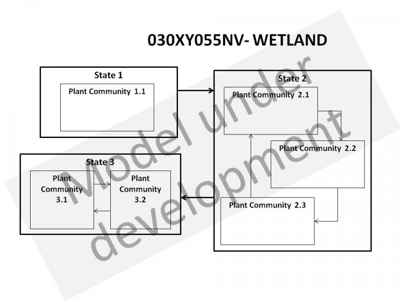
More interactive model formats are also available.
View Interactive Models
Click on state and transition labels to scroll to the respective text
Ecosystem states
State 1 submodel, plant communities
State 1
Reference State
The reference state is representative of the natural range of variability under pristine conditions. Period natural disturbances affecting this state include drought, wildfire, disease or insect attack. Plant community dynamics are driven by interactions between climate patterns and disturbance regimes.
Community 1.1
Reference Plant Community
The reference plant community is dominated by rushes, sedges, bulrush, common reed, cattail, and pondweed. Potential vegetative composition is about 85% grasses and grass-like plants, 10% forbs, and 5% shrubs and trees. Approximate ground cover (basal and crown) is less than 40 to 70 percent.
Figure 2. Annual production by plant type (representative values) or group (midpoint values)
Table 5. Annual production by plant type
| Plant type | Low (lb/acre) |
Representative value (lb/acre) |
High (lb/acre) |
|---|---|---|---|
| Grass/Grasslike | 1700 | 2380 | 3400 |
| Forb | 200 | 280 | 400 |
| Shrub/Vine | 100 | 140 | 200 |
| Total | 2000 | 2800 | 4000 |
Additional community tables
Table 6. Community 1.1 plant community composition
| Group | Common name | Symbol | Scientific name | Annual production (lb/acre) | Foliar cover (%) | |
|---|---|---|---|---|---|---|
|
Grass/Grasslike
|
||||||
| 1 | Primary Perennial Grasses | 1456–2660 | ||||
| rush | JUNCU | Juncus | 560–840 | – | ||
| sedge | CAREX | Carex | 280–560 | – | ||
| bulrush | SCIRP | Scirpus | 280–420 | – | ||
| cattail | TYPHA | Typha | 140–280 | – | ||
| common reed | PHAU7 | Phragmites australis | 140–280 | – | ||
| bluegrass | POA | Poa | 56–280 | – | ||
| 2 | Secondary Perennial Grasses | 56–224 | ||||
| saltgrass | DISP | Distichlis spicata | 14–56 | – | ||
| alkali sacaton | SPAI | Sporobolus airoides | 14–56 | – | ||
|
Forb
|
||||||
| 3 | Perennial Forbs | 280–420 | ||||
| European water plantain | ALPL | Alisma plantago-aquatica | 14–84 | – | ||
| Rocky Mountain iris | IRMI | Iris missouriensis | 14–84 | – | ||
| pondweed | POTAM | Potamogeton | 14–84 | – | ||
| 4 | Annual Forbs | 1–84 | ||||
|
Shrub/Vine
|
||||||
| 5 | Secondary Perennial Shrubs | 1–224 | ||||
| cottonwood | POPUL | Populus | 28–140 | – | ||
| mesquite | PROSO | Prosopis | 28–140 | – | ||
| willow | SALIX | Salix | 28–140 | – | ||
Interpretations
Animal community
Livestock Interpretations:
This site is suitable for livestock grazing. Grazing management should be keyed to perennial grass production. Baltic rush is described as a fair to good forage species for cattle. On average, Baltic rush’s palatability is considered medium to moderately low. Baltic rush is considered palatable early in the growing season when plants are young and tender, but as stems mature and toughen palatability declines. Sedge provides good to fair forage for domestic grazing. Bulrush herbage production is high, but forage value is low. It is seldom grazed by livestock if other forage is available. If upland forage becomes limited and soil conditions dry, livestock may utilize bulrush. Common reed is moderately tolerant of grazing, but prolonged heavy grazing tends to reduce the extent and size of stands. Common cattail is generally considered poor livestock forage. These animals rarely graze common cattail unless upland forage becomes scarce.
Stocking rates vary over time depending upon season of use, climate variations, site, and previous and current management goals. A safe starting stocking rate is an estimated stocking rate that is fine tuned by the client by adaptive management through the year and from year to year.
Wildlife Interpretations:
Baltic rush provides food for several wildlife species and waterfowl. Baltic rush is an important cover species for a variety of small birds, upland game birds, birds of prey, and waterfowl. Sedges have a high to moderate resource value for elk and a medium value for mule deer. Elk consume beaked sedge later in the growing season. The hard-coated seeds of bulrushes are one of the most important and most commonly used foods of ducks and of certain marshbirds and shorebirds. The stems and underground parts are eaten by muskrats and geese. Bulrushes also furnish important nesting cover for waterfowl as well as for marsh wrens and blackbirds and give concealing protection to muskrats, otters, raccoons and other animals. Common reed provides shade, nesting, and cover habitat for mammals, waterfowl, song birds, and fishes. Common reed is not rated as a high-value wildlife food unless plants are young. Common cattail rootstocks are much more valuable as food for wildlife than are the seeds. Geese and muskrats use the starchy underground stems a great deal. Cattails also provide valuable shelter and nesting cover for several species of songbirds. For ducks, cattails have relatively little value. They furnish cover but they also take the place of more useful plants that would furnish both food and cover.
Hydrological functions
Rills and waterflow patterns are none. Soils are typically very poorly drained. Ponded water during most or all of the year with no runoff.
Recreational uses
Aesthetic value is derived from the diverse floral and faunal composition. This site offers rewarding opportunities to photographers and for nature study. This site has potential for waterfowl and big game hunting.
Other products
Common reed was utilized as a food source and as a medicine by Native Americans. Shoots were eaten raw or cooked. Flour was made from dried shoots and rhizomes. Common reed rhizomes provided a year-round food source. Seeds were harvested and ground into a high fiber meal. The plant material was used to construct pipestems, arrows, mats, nets, and prayer sticks. Native Americans used common cattail as food. Rhizomes were dried and ground into flour or eaten as cooked vegetables; young stems were eaten raw or cooked; and immature fruiting spikes were eaten after roasting. The leaves were woven for matting and the soft down from ripe fruiting heads was used as padding and in diapers.
Other information
Bulrush erosion control and short-term and long-term revegetation potential are rated as medium. Bulrush buffers wind and wave action on lakes and ponds, which may enhance the establishment of vegetation along shorelines. Ease of establishment, rapid vegetative spread, and high tolerance of disturbance make common reed an understandable choice for rehabilitation. However, these same traits make common reed a nuisance or weedy species in some areas. In natural or wild areas, the use of native common reed haplotypes may be required or preferred.
Supporting information
Type locality
| Location 1: Nye County, NV | |
|---|---|
| Township/Range/Section | T18S R50E S13 |
| UTM zone | N |
| UTM northing | 4027088 |
| UTM easting | 563427 |
| Latitude | 36° 23′ 12″ |
| Longitude | 116° 17′ 34″ |
| General legal description | Ash Meadows area in vicinity of Bole and Big Spring, Nye County, Nevada. This site also occurs in Clark, and Lincoln Counties, Nevada. |
Other references
Fire Effects Information System (Online; http://www.fs.fed.us/database/feis/plants/).
USDA-NRCS Plants Database (Online; http://www.plants.usda.gov).
Contributors
HA
Approval
Sarah Quistberg, 2/24/2025
Rangeland health reference sheet
Interpreting Indicators of Rangeland Health is a qualitative assessment protocol used to determine ecosystem condition based on benchmark characteristics described in the Reference Sheet. A suite of 17 (or more) indicators are typically considered in an assessment. The ecological site(s) representative of an assessment location must be known prior to applying the protocol and must be verified based on soils and climate. Current plant community cannot be used to identify the ecological site.
| Author(s)/participant(s) | P.Novak-Echenique/E.Hourihan |
|---|---|
| Contact for lead author | STATE RANGE MANAGEMENT SPECIALIST |
| Date | 11/16/2011 |
| Approved by | Sarah Quistberg |
| Approval date | |
| Composition (Indicators 10 and 12) based on | Annual Production |
Indicators
-
Number and extent of rills:
None -
Presence of water flow patterns:
None -
Number and height of erosional pedestals or terracettes:
None -
Bare ground from Ecological Site Description or other studies (rock, litter, lichen, moss, plant canopy are not bare ground):
None -
Number of gullies and erosion associated with gullies:
None -
Extent of wind scoured, blowouts and/or depositional areas:
None -
Amount of litter movement (describe size and distance expected to travel):
Fine litter only expected to move during periods of flooding by adjacent streams. -
Soil surface (top few mm) resistance to erosion (stability values are averages - most sites will show a range of values):
Surface soil stability values will range from 4 to 6. (To be field tested.) -
Soil surface structure and SOM content (include type of structure and A-horizon color and thickness):
Immediate surface soil is often well-decomposed organic soil material with more than 12% OM. Mineral soils have platy or massive surface soil structure with organic matter ranging from 2.5 to over 5 percent in the upper 10 inches. -
Effect of community phase composition (relative proportion of different functional groups) and spatial distribution on infiltration and runoff:
These plant communities are ponded during most, if not all, of the year and there is no runoff. -
Presence and thickness of compaction layer (usually none; describe soil profile features which may be mistaken for compaction on this site):
None -
Functional/Structural Groups (list in order of descending dominance by above-ground annual-production or live foliar cover using symbols: >>, >, = to indicate much greater than, greater than, and equal to):
Dominant:
Reference Plant Community: Grass-like plants >>Sub-dominant:
water-loving, perennial, forbs > deciduous shrubs > water-loving, annual, forbs >> perennial grassesOther:
deciduous treesAdditional:
-
Amount of plant mortality and decadence (include which functional groups are expected to show mortality or decadence):
Herbaceous plant mortality or decadence uncommon -
Average percent litter cover (%) and depth ( in):
Litter cover is commonly 100% within plant interspaces and depth of litter is 6-inches to more than 24-inches. -
Expected annual annual-production (this is TOTAL above-ground annual-production, not just forage annual-production):
For normal or average growing season ± 2800 lbs/ac. Favorable years 4000+ lbs/ac and unfavorable yeras 2000 lbs/ac. -
Potential invasive (including noxious) species (native and non-native). List species which BOTH characterize degraded states and have the potential to become a dominant or co-dominant species on the ecological site if their future establishment and growth is not actively controlled by management interventions. Species that become dominant for only one to several years (e.g., short-term response to drought or wildfire) are not invasive plants. Note that unlike other indicators, we are describing what is NOT expected in the reference state for the ecological site:
Potential invaders include saltcedar, foxtail barley and thistles. -
Perennial plant reproductive capability:
All functional groups should reproduce in most years.
Print Options
Sections
Font
Other
The Ecosystem Dynamics Interpretive Tool is an information system framework developed by the USDA-ARS Jornada Experimental Range, USDA Natural Resources Conservation Service, and New Mexico State University.
Click on box and path labels to scroll to the respective text.