Natural Resources
Conservation Service
Ecological site R040XC330AZ
Sandy Loam Drainage 3"-7" p.z.
Last updated: 3/04/2025
Accessed: 05/12/2025
General information
Provisional. A provisional ecological site description has undergone quality control and quality assurance review. It contains a working state and transition model and enough information to identify the ecological site.
MLRA notes
Major Land Resource Area (MLRA): 040X–Sonoran Basin and Range
Major Land Resource Area (MLRA) 40 is the portion of Sonoran Desert that extends from northwest Mexico into southwestern Arizona and southeastern California. This MLRA is hot desert characterized by bimodal precipitation coupled with hot summers and mild winters. These conditions give rise to a rich biological diversity visually dominated by columnar cactus (saguaro) and leguminous trees (palo verde). This unit occurs within the Basin and Range Physiographic Province and is characterized by numerous mountain ranges that rise abruptly from broad, plain-like valleys and basins. Igneous and metamorphic rock classes dominate the mountain ranges, and basin sediments are combinations of fluvial, lacustrine, colluvial and alluvial deposits.
LRU notes
Land Resource Unit (LRU) 40-3, Colorado Sonoran Desert, is characterized by desert scrub vegetation. High amounts of desert pavement are present on relict fan remnants. Trees are only in large washes and on hillslopes. Elevations range from 300 to 1200 feet, and precipitation averages 3 to 7 inches per year. Vegetation includes creosotebush, white bursage, brittlebush, Mormon tea, teddybear cholla, elephant tree, smoke tree, ocotillo, and big galleta. The soil temperature regime is hyperthermic and the soil moisture regime is typic aridic.
Classification relationships
USDA-NRCS Land Resource Regions and Major Land Resource Areas of the United States, the Caribbean, and the Pacific Basin: Western Range and Irrigated Region D Major Land Resource Area 40 - Sonoran Basin and Range Land Resource Unit 3 - Lower Sonoran Desert Ecological Site Sandy Loam Drainage, 3"-7" p.z.
U.S. Environmental Protection Agency, Ecological Regions of North America: Level I, Region 10 North American Deserts Level II, 10.2 Warm Deserts Level III, Ecoregion 81, Sonoran Basin and Range Level IV, 81l, 81n, 81o
USDA-USFS Ecological Subregions: Sections of the Conterminous United States Section 322 American Semidesert and Desert Province Section 322B, Sonoran Desert
Ecological site concept
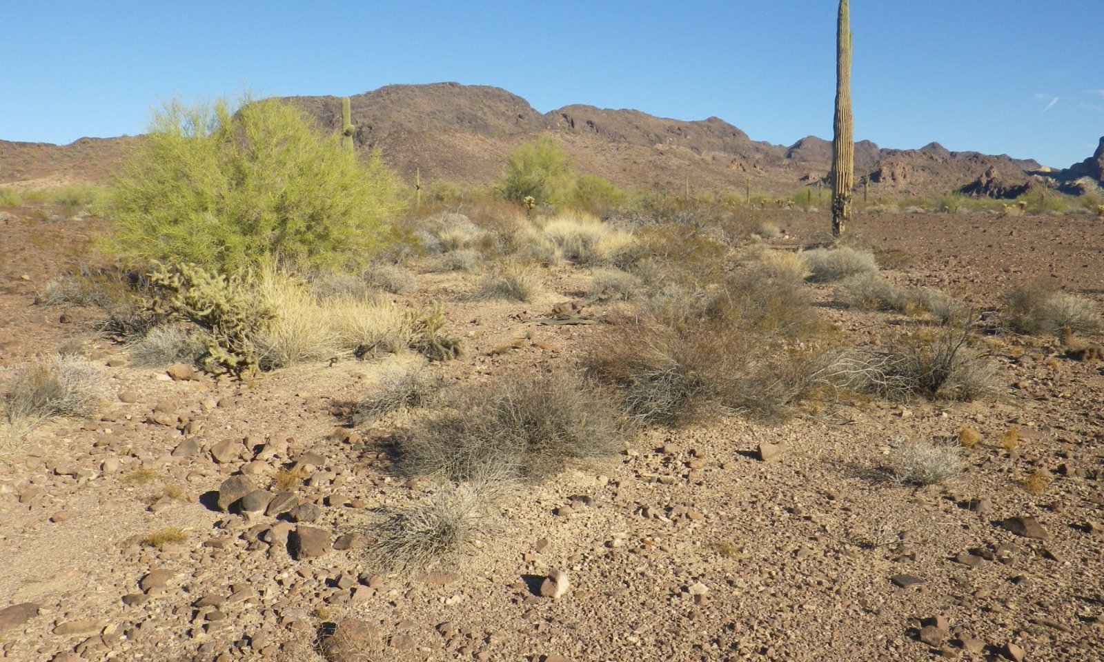
Sandy Loam Drainage, 3”-7” p.z., occurs in a bottom position with sandy to sandy loam soils. The site appears as a braided drainage through Limy Upland, Deep, 3"-7" p.z., and Desert Pavement, 3"-7" p.z., ecological sites. Terrain is flat to very gently sloping and collects run-on from adjacent landscapes. Active water flow paths are less than 4' wide. Water flows are ephemeral, but the plant community benefits from all run-on moisture received. Aspect is desert shrubland.
Associated sites
| R040XC326AZ |
Desert Pavement 3"-7" p.z. |
|---|---|
| R040XC311AZ |
Limy Upland, Deep 3"-7" p.z. |
Similar sites
| R040XB229AZ |
Sandy Loam Drainage 7"-10" p.z. Elevation 1,200' - 2,000'; precipitation zone 7 |
|---|
Table 1. Dominant plant species
| Tree |
Not specified |
|---|---|
| Shrub |
(1) Larrea tridentata |
| Herbaceous |
(1) Pleuraphis rigida |
Physiographic features
This site occurs on floodplains and alluvial fans. It regularly receives run-on moisture from overbank flooding and runoff from adjacent upland sites. Slopes range from 0% to 3%.
Table 2. Representative physiographic features
| Landforms |
(1)
Terrace
(2) Alluvial fan |
|---|---|
| Elevation | 300 – 1,200 ft |
Climatic features
Annual precipitation ranges from 3 to 7 inches. Annual rainfall is bimodal, with distinct rainy seasons occurring from December to March (winter) and July to September (summer). Rainfall ratios range from 40:60 (winter:summer). Rainfall intensity differs between rainfall seasons. Winter frontal storms develop in the Pacific Ocean and Gulf of California, producing widespread, low-intensity and long duration precipitation events. Winter precipitation is the more dependable water source for vegetation, and snowfall is very rare. During summer months, atmospheric activity in the Gulf of Mexico produces convective thunderstorms when crossing over the mountains in the afternoon. These storms travel across the plains and valleys, producing precipitation of short duration, usually less than 30 minutes, but of moderate to heavy intensity. However, these thunderstorms often produce little more than gusty winds and light showers. Between these two seasons, little to no effective precipitation can occur for several months at a time. May and June are the driest months, and overall humidity is very low.
Overall, average annual rainfall is variable, but increases in variability from east to west across the region. For long-term precipitation data, the coefficient of variation, the ratio of the standard deviation to the mean expressed as a percentage, increases from 44% at Gila Bend (east) to 65% at Mohawk (west).
Winter temperatures are very mild, with an average of 53°F in January, with recorded extremes of 10°F. Summertime temperatures are hot to very hot, averaging 93°F in July, and with recorded extremes of 125°F. Spring and summer growing seasons are equally important for perennial grass, forb and shrub and tree growth. With above average precipitation, cool and warm season annuals, forbs and grasses can be common in their respective seasons. Perennial forbs may only be visible above ground following rainfall events.
Table 3. Representative climatic features
| Frost-free period (average) | 303 days |
|---|---|
| Freeze-free period (average) | 348 days |
| Precipitation total (average) | 7 in |
Figure 1. Monthly precipitation range
Figure 2. Monthly average minimum and maximum temperature
Influencing water features
Soil features
These very young soils occur on gravelly and sandy alluvium of mixed origin. Textures range from sandy loam to very cobbly sands. Soils are well to excessively drained.
Table 4. Representative soil features
| Surface texture |
(1) Very gravelly sandy loam (2) Extremely gravelly fine sandy loam (3) Sand |
|---|---|
| Family particle size |
(1) Loamy |
| Drainage class | Well drained |
| Permeability class | Moderately slow to rapid |
| Soil depth | 60 in |
| Surface fragment cover <=3" | 10 – 60% |
| Surface fragment cover >3" | 1 – 10% |
| Available water capacity (0-40in) |
2.4 – 4.8 in |
| Calcium carbonate equivalent (0-40in) |
2 – 35% |
| Electrical conductivity (0-40in) |
2 mmhos/cm |
| Sodium adsorption ratio (0-40in) |
Not specified |
| Soil reaction (1:1 water) (0-40in) |
7.9 – 8.4 |
| Subsurface fragment volume <=3" (Depth not specified) |
10 – 60% |
| Subsurface fragment volume >3" (Depth not specified) |
1 – 10% |
Ecological dynamics
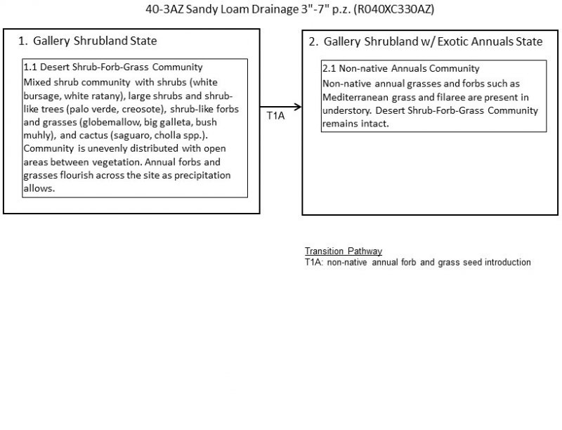
Sandy Loam Drainage, 3”-7” p.z., potential plant community is diverse and productive as the site benefits from rainfall run-on from adjacent ecological sites. Sandy Loam Drainage has two states, Gallery Shrubland (Reference) and Gallery Shrubland with Exotic Annuals. Although a degraded state may occur, no alternate states were observed. Aspect is gallery shrubland.
State and transition model
More interactive model formats are also available.
View Interactive Models
More interactive model formats are also available.
View Interactive Models
Click on state and transition labels to scroll to the respective text
Ecosystem states
State 1 submodel, plant communities
State 2 submodel, plant communities
State 1
Gallery Shrubland
Sandy Loam Drainage, 3”-7” p.z., occurs as small watercourses within a landscape complex of Limy Upland, Deep, and Desert Pavement ecological sites. Terrain is gently sloping. Soil is sandy to sandy loam in texture. Infiltration rate is moderate to high. The potential plant community is highly diverse and productive as the site benefits from rainfall run-on from adjacent ecological sites.
Community 1.1
Desert Shrub-Forb-Grass

The Desert Shrub-Forb-Grass community is a diverse mixture of shrubs, perennial grasses and cactus. Tree species do occur, but generally are less than 8' in height and have the characteristics of large shrubs. Annual production values and community composition change in relation to the quantity of run-on water present in different sections of the drainage system. In the upper portion of a drainage, with less run-on water contribution, the plant community is open and simple. i. Toward the end of the drainage, a larger run-off source area contributes more available water which can support a denser and more complex plant community.
Figure 3. Annual production by plant type (representative values) or group (midpoint values)
Table 5. Annual production by plant type
| Plant type | Low (lb/acre) |
Representative value (lb/acre) |
High (lb/acre) |
|---|---|---|---|
| Shrub/Vine | 20 | 46 | 84 |
| Grass/Grasslike | 2 | 20 | 45 |
| Tree | 5 | 27 | 45 |
| Forb | 2 | 7 | 17 |
| Total | 29 | 100 | 191 |
Table 6. Soil surface cover
| Tree basal cover | 0% |
|---|---|
| Shrub/vine/liana basal cover | 0% |
| Grass/grasslike basal cover | 0% |
| Forb basal cover | 0% |
| Non-vascular plants | 0% |
| Biological crusts | 4-15% |
| Litter | 4-9% |
| Surface fragments >0.25" and <=3" | 28-52% |
| Surface fragments >3" | 1-7% |
| Bedrock | 0% |
| Water | 0% |
| Bare ground | 29-54% |
Table 7. Canopy structure (% cover)
| Height Above Ground (ft) | Tree | Shrub/Vine | Grass/ Grasslike |
Forb |
|---|---|---|---|---|
| <0.5 | – | – | – | – |
| >0.5 <= 1 | – | – | – | – |
| >1 <= 2 | – | 1-2% | 0-2% | – |
| >2 <= 4.5 | – | 2-8% | – | – |
| >4.5 <= 13 | 0-7% | – | – | – |
| >13 <= 40 | – | – | – | – |
| >40 <= 80 | – | – | – | – |
| >80 <= 120 | – | – | – | – |
| >120 | – | – | – | – |
State 2
Gallery Shrubland w/ Exotic Annuals
Community 2.1
Non-Native Annuals
This plant community includes non-native annual forbs and grasses in the understory.
Transition T1A
State 1 to 2
Introduction of non-native annual forb and grass seed.
Additional community tables
Table 8. Community 1.1 plant community composition
| Group | Common name | Symbol | Scientific name | Annual production (lb/acre) | Foliar cover (%) | |
|---|---|---|---|---|---|---|
|
Grass/Grasslike
|
||||||
| 1 | Perennial Grasses | 0–30 | ||||
| big galleta | PLRI3 | Pleuraphis rigida | 1–19 | – | ||
| bush muhly | MUPO2 | Muhlenbergia porteri | 0–10 | – | ||
| threeawn | ARIST | Aristida | 0–1 | – | ||
| 2 | Annual Grasses | 2–15 | ||||
| sixweeks threeawn | ARAD | Aristida adscensionis | 0–15 | – | ||
| needle grama | BOAR | Bouteloua aristidoides | 0–15 | – | ||
| sixweeks grama | BOBA2 | Bouteloua barbata | 0–15 | – | ||
| low woollygrass | DAPU7 | Dasyochloa pulchella | 0–15 | – | ||
| sixweeks fescue | VUOC | Vulpia octoflora | 0–15 | – | ||
|
Forb
|
||||||
| 3 | Perennial Forbs | 0–2 | ||||
| narrowleaf silverbush | ARLA12 | Argythamnia lanceolata | 0–2 | – | ||
| desert globemallow | SPAM2 | Sphaeralcea ambigua | 0–2 | – | ||
| desert lily | HEUN2 | Hesperocallis undulata | 0–1 | – | ||
| desert marigold | BAMU | Baileya multiradiata | 0–1 | – | ||
| desert trumpet | ERIN4 | Eriogonum inflatum | 0–1 | – | ||
| buckwheat | ERIOG | Eriogonum | 0–1 | – | ||
| desert globemallow | SPAM2 | Sphaeralcea ambigua | 0–1 | – | ||
| 4 | Annual Forbs | 2–15 | ||||
| common fiddleneck | AMMEI2 | Amsinckia menziesii var. intermedia | 0–1 | – | ||
| bristly fiddleneck | AMTE3 | Amsinckia tessellata | 0–1 | – | ||
| desert marigold | BAMU | Baileya multiradiata | 0–1 | – | ||
| suncup | CAMIS | Camissonia | 0–1 | – | ||
| brittle spineflower | CHBR | Chorizanthe brevicornu | 0–1 | – | ||
| devil's spineflower | CHRI | Chorizanthe rigida | 0–1 | – | ||
| Esteve's pincushion | CHST | Chaenactis stevioides | 0–1 | – | ||
| cryptantha | CRYPT | Cryptantha | 0–1 | – | ||
| hairy prairie clover | DAMO | Dalea mollis | 0–1 | – | ||
| western tansymustard | DEPI | Descurainia pinnata | 0–1 | – | ||
| desert woollystar | ERER2 | Eriastrum eremicum | 0–1 | – | ||
| desert trumpet | ERIN4 | Eriogonum inflatum | 0–1 | – | ||
| spurge | EUPHO | Euphorbia | 0–1 | – | ||
| Gordon's bladderpod | LEGO | Lesquerella gordonii | 0–1 | – | ||
| Coulter's lupine | LUSP2 | Lupinus sparsiflorus | 0–1 | – | ||
| glandular threadplant | NEGL | Nemacladus glanduliferus | 0–1 | – | ||
| phacelia | PHACE | Phacelia | 0–1 | – | ||
| sleepy silene | SIAN2 | Silene antirrhina | 0–1 | – | ||
| Coulter's globemallow | SPCO2 | Sphaeralcea coulteri | 0–1 | – | ||
| spinyhair blazingstar | METR2 | Mentzelia tricuspis | 0–1 | – | ||
| western tansymustard | DEPI | Descurainia pinnata | 0–1 | – | ||
| desert Indianwheat | PLOV | Plantago ovata | 0–1 | – | ||
| pepperweed | LEAP6 | Lepidium apetalum | 0–1 | – | ||
| devil's spineflower | CHRI | Chorizanthe rigida | 0–1 | – | ||
|
Shrub/Vine
|
||||||
| 5 | Large Shrubs | 15–55 | ||||
| ocotillo | FOSP2 | Fouquieria splendens | 0–11 | – | ||
| creosote bush | LATR2 | Larrea tridentata | 2–8 | – | ||
| burrobush | AMDU2 | Ambrosia dumosa | 4–8 | – | ||
| desert-thorn | LYCIU | Lycium | 0–5 | – | ||
| brittlebush | ENFA | Encelia farinosa | 2–4 | – | ||
| white ratany | KRGR | Krameria grayi | 2–4 | – | ||
| Death Valley jointfir | EPFU | Ephedra funerea | 0–2 | – | ||
| Nevada jointfir | EPNE | Ephedra nevadensis | 0–2 | – | ||
| catclaw acacia | SEGR4 | Senegalia greggii | 0–1 | – | ||
| 6 | Subshrubs | 5–25 | ||||
| slender poreleaf | POGR5 | Porophyllum gracile | 1–5 | – | ||
| California fagonbush | FALA | Fagonia laevis | 0–3 | – | ||
| desertsenna | SEAR8 | Senna armata | 0–1 | – | ||
| rush milkweed | ASSU | Asclepias subulata | 0–1 | – | ||
| whitestem paperflower | PSCO2 | Psilostrophe cooperi | 0–1 | – | ||
| lotebush | ZIOB | Ziziphus obtusifolia | 0–1 | – | ||
| desert woollystar | ERER2 | Eriastrum eremicum | 0–1 | – | ||
| glandular threadplant | NEGL | Nemacladus glanduliferus | 0–1 | – | ||
| 7 | Cactus | 0–4 | ||||
| saguaro | CAGI10 | Carnegiea gigantea | 0–1 | – | ||
| buckhorn cholla | CYACA2 | Cylindropuntia acanthocarpa var. acanthocarpa | 0–1 | – | ||
| teddybear cholla | CYBI9 | Cylindropuntia bigelovii | 0–1 | – | ||
| Wiggins' cholla | CYEC3 | Cylindropuntia echinocarpa | 0–1 | – | ||
| Christmas cactus | CYLE8 | Cylindropuntia leptocaulis | 0–1 | – | ||
| branched pencil cholla | CYRA9 | Cylindropuntia ramosissima | 0–1 | – | ||
| Engelmann's hedgehog cactus | ECEN | Echinocereus engelmannii | 0–1 | – | ||
| California barrel cactus | FECYC | Ferocactus cylindraceus var. cylindraceus | 0–1 | – | ||
| candy barrelcactus | FEWI | Ferocactus wislizeni | 0–1 | – | ||
| globe cactus | MAMMI | Mammillaria | 0–1 | – | ||
| beavertail pricklypear | OPBA2 | Opuntia basilaris | 0–1 | – | ||
|
Tree
|
||||||
| 8 | Tree | 5–45 | ||||
| desert ironwood | OLTE | Olneya tesota | 0–20 | – | ||
| yellow paloverde | PAMI5 | Parkinsonia microphylla | 0–10 | – | ||
Interpretations
Supporting information
Other references
Griffith, G.E., Omernik, J.M., Johnson, C.B., and Turner, D.S., 2014, Ecoregions of Arizona (poster): U.S. Geological Survey Open-File Report 2014-1141, with map, scale 1:1,325,000, https://dx.doi.org/10.3133/ofr20141141. ISSN 2331-1258 (online)
United States Department of Agriculture, Natural Resources Conservation Service. 2006. Land Resource Regions and Major Land Resource Areas of the United States, the Caribbean, and the Pacific Basin. U.S. Department of Agriculture Handbook 296.
Contributors
Wilma Renken
Approval
Kendra Moseley, 3/04/2025
Rangeland health reference sheet
Interpreting Indicators of Rangeland Health is a qualitative assessment protocol used to determine ecosystem condition based on benchmark characteristics described in the Reference Sheet. A suite of 17 (or more) indicators are typically considered in an assessment. The ecological site(s) representative of an assessment location must be known prior to applying the protocol and must be verified based on soils and climate. Current plant community cannot be used to identify the ecological site.
| Author(s)/participant(s) | |
|---|---|
| Contact for lead author | |
| Date | 03/06/2025 |
| Approved by | Kendra Moseley |
| Approval date | |
| Composition (Indicators 10 and 12) based on | Annual Production |
Indicators
-
Number and extent of rills:
-
Presence of water flow patterns:
-
Number and height of erosional pedestals or terracettes:
-
Bare ground from Ecological Site Description or other studies (rock, litter, lichen, moss, plant canopy are not bare ground):
-
Number of gullies and erosion associated with gullies:
-
Extent of wind scoured, blowouts and/or depositional areas:
-
Amount of litter movement (describe size and distance expected to travel):
-
Soil surface (top few mm) resistance to erosion (stability values are averages - most sites will show a range of values):
-
Soil surface structure and SOM content (include type of structure and A-horizon color and thickness):
-
Effect of community phase composition (relative proportion of different functional groups) and spatial distribution on infiltration and runoff:
-
Presence and thickness of compaction layer (usually none; describe soil profile features which may be mistaken for compaction on this site):
-
Functional/Structural Groups (list in order of descending dominance by above-ground annual-production or live foliar cover using symbols: >>, >, = to indicate much greater than, greater than, and equal to):
Dominant:
Sub-dominant:
Other:
Additional:
-
Amount of plant mortality and decadence (include which functional groups are expected to show mortality or decadence):
-
Average percent litter cover (%) and depth ( in):
-
Expected annual annual-production (this is TOTAL above-ground annual-production, not just forage annual-production):
-
Potential invasive (including noxious) species (native and non-native). List species which BOTH characterize degraded states and have the potential to become a dominant or co-dominant species on the ecological site if their future establishment and growth is not actively controlled by management interventions. Species that become dominant for only one to several years (e.g., short-term response to drought or wildfire) are not invasive plants. Note that unlike other indicators, we are describing what is NOT expected in the reference state for the ecological site:
-
Perennial plant reproductive capability:
Print Options
Sections
Font
Other
The Ecosystem Dynamics Interpretive Tool is an information system framework developed by the USDA-ARS Jornada Experimental Range, USDA Natural Resources Conservation Service, and New Mexico State University.
Click on box and path labels to scroll to the respective text.