Ecological dynamics
It is impossible to determine in any quantitative detail the Historic Climax Plant Community (HCPC) for this ecological site because of the lack of direct historical documentation preceding all human influence. In the 1860s, Europeans brought cattle and horses to the area, grazing large numbers of them on unfenced parcels year-long.
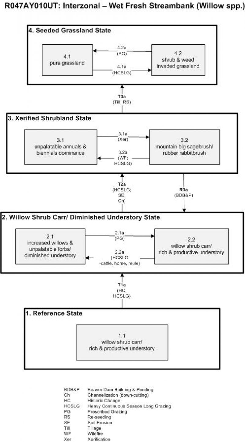
Below is a State and Transition Model diagram to illustrate the “phases” (common plant communities), and “states” (aggregations of those plant communities) that can occur on the site. Differences between phases and states depend primarily upon observations of a range of disturbance histories in areas where this ESD is represented. These situations include grazing gradients to water sources, fence-line contrasts, patches with differing dates of fire, herbicide treatment, tillage, etc. Reference State 1 illustrates the common plant communities that probably existed just prior to European settlement.
The major successional pathways within states, (“community pathways”) are indicated by arrows between phases. “Transitions” are indicated by arrows between states. The drivers of these changes are indicated in codes decipherable by referring to the legend at the bottom of the page and by reading the detailed narratives that follow the diagram. The transition between Reference State 1 and State 2 is considered irreversible because of the naturalization of exotic species of both flora and fauna, possible extinction of native species, and climate change. There may have also been accelerated soil erosion.
When available, monitoring data (of various types) were employed to validate more subjective inferences made in this diagram. See the complete files in the office of the State Range Conservationist for more details.
State 1
Reference State
The Reference State is a description of this ecological site prior to Euro-American settlement but long after the arrival of Native Americans. The description of the Reference State was determined by NRCS Soil Survey Type Site Location information and familiarity with rangeland relict areas where they exist. The least modified plant community (1.1) within the Reference State would have been a carr (i.e. tall shrub-dominated wetland) dominated by willows (Booth's willow (Salix boothii), shortfruit willow (Salix brachycarpa), Drummond's willow (Salix drummondiana), Geyer willow (Salix geyeriana), grayleaf willow (Salix glauca), Bebb willow (Salix bebbiana), Pacific willow (Salix lucida ssp. lasiandra), yellow willow (Salix lutea), and/or Scouler’s willow (Salix scouleriana)), species depending on geographic region. This list of willow species may be different than those listed in the “Plant Community Composition by Weight and Percentage” section of this document because these species are identified in higher elevations (Montane and Sub-alpine zones) only.
Dominant grasses would have included tufted hairgrass (Deschampsia cespitosa), blue wildrye (Elymus glaucus), and mountain brome (Bromus marginatus), and the grass-like water sedge (Carex aquatilis). Associated forbs would have included common cowparsnip (Heracleum maximum), field horsetail (Equisetum arvense), and feathery false lily of the valley (Maianthemum racemosum). Englemann spruce (Picea engelmannii) and blue spruce (Picea pungens) would have also occurred sparingly as small trees. Tree species present indicated where this phase was located topographically.
Community 1.1
Willow shrub carr/ rich & productive understory
Without disturbance, the Reference State would have been dominated by woody plants. The proportion of woody plants in relation to herbaceous understory species would have been influenced by the time and type of natural disturbance that most recently took place. Possible natural disturbances would have included beaver and moose consumption of willow, deciduous wood pathogens (i.e. insects) reducing particular species, wildfires, and extreme run-off causing flooding or diversion of existing drainages. Such disturbances would have temporarily decreased the woody component and allowed an increase in herbs. All of these influences tended to have very long return intervals. Without such disturbance, woody plants would have increased at the expense of the understory because of the overtopping shade they create.
Table 6. Annual production by plant type
| Plant type |
Low
(lb/acre) |
Representative value
(lb/acre) |
High
(lb/acre) |
| Grass/Grasslike |
1170 |
1512 |
2070 |
| Shrub/Vine |
478 |
630 |
863 |
| Forb |
23 |
378 |
518 |
| Total |
1671 |
2520 |
3451 |
Table 7. Ground cover
| Tree foliar cover |
49-51%
|
| Shrub/vine/liana foliar cover |
19-21%
|
| Grass/grasslike foliar cover |
19-21%
|
| Forb foliar cover |
4-6%
|
| Non-vascular plants |
0%
|
| Biological crusts |
0%
|
| Litter |
0%
|
| Surface fragments >0.25" and <=3" |
0%
|
| Surface fragments >3" |
0%
|
| Bedrock |
0%
|
| Water |
0%
|
| Bare ground |
0%
|
Table 8. Canopy structure (% cover)
| Height Above Ground (ft) |
Tree |
Shrub/Vine |
Grass/
Grasslike |
Forb |
| <0.5 |
– |
– |
– |
– |
| >0.5 <= 1 |
– |
– |
– |
4-6% |
| >1 <= 2 |
– |
– |
19-21% |
– |
| >2 <= 4.5 |
– |
– |
– |
– |
| >4.5 <= 13 |
– |
19-21% |
– |
– |
| >13 <= 40 |
– |
– |
– |
– |
| >40 <= 80 |
49-51% |
– |
– |
– |
| >80 <= 120 |
– |
– |
– |
– |
| >120 |
– |
– |
– |
– |
State 2
Willow Shrub Carr/ Diminished Understory State
State 2 is very similar to State 1 in form and function, with the exception of the presence of non-native plants and animals, possible extinctions of native species, and a different climate.
State 2 is a description of the ecological site shortly following Euro-American settlement. This state can be regarded as the current potential. State 2 can fluctuate between two willow-dominated phases: one that is relatively undisturbed with a rich and productive understory (2.2), and another where the understory is reduced due to the heavy livestock grazing (2.1). Phase 2.1 is a willow (Salix spp.) stand with a reduced understory due to the heavy livestock grazing. This Phase was also produced by horses and mules belonging to early European settlers and travelers (2.2a). These areas usually have surface water available, an attractant to most animals in the vicinity, which tend to pass through these stands at least once daily to feed, get water, and find shade. Heavy use of this part of the landscape was common until the creation of the Forest Reserves and U.S. Forest Service, when forest managers began to require users to be more sensitive of these areas. When the U.S. Forest Service began regulating use of their lands, including areas occupied by this ESD (circa 1910), the number of livestock and their season of use was reduced drastically, salt was placed only on upland locations, and sheep camps were required to be moved often. Because of the high resilience of these sub-irrigated habitats, partial recovery of the understory was attained in many instances and accelerated soil erosion arrested. Sustainable use was approached in such instances (2.1a).
Community 2.1
Increased willows & unpalatable forbs/ diminished understory
Periods of heavy livestock and trail stock grazing of the herbaceous understory, along with near-extirpation of beaver and moose, causes this plant community to experience an increase in the proportion of woody plants at the expense of the herbaceous understory. Sedges, unpalatable forbs, and woody species are increased.
Community 2.2
Willow shrub carr/ rich & productive understory
This plant community has regained the understory components following a period of reduction in livestock use.
Pathway 2.1a
Community 2.1 to 2.2
A reduction in livestock numbers and limiting seasons of use allows the understory component to rejuvenate.
Pathway 2.2a
Community 2.2 to 2.1
Heavy continuous season-long grazing by livestock reduces the palatable understory species. This occurred in the past when these sites were common places for travelers to feed and water their animals.
State 3
Xerified Shrubland State
Where control of grazing intensity isn’t been achieved earlier and excessive use by livestock prevails, the vegetation takes on more of the character of that of drier sites at low elevations. As the water table is lowered, the stature of the willows and other riparian shrubs declines, allowing upland species such as rubber rabbitbrush (Ericameria nauseosus), mountain big sagebrush (Artemisia tridentata ssp. vaseyana), and snowfield sagebrush (Artemisia spiciformis) to fill in these sites (3.2). Wildfire followed by continued heavy livestock grazing (3.2a) will temporarily remove the shrub and palatable herbaceous component, leaving annuals and biennials such as lesser burdock (Arctium minus), rough cocklebur (Xanthium strumarium), horehound (Marrubium vulgare), houndstongue (Cynoglossum officinale), stickseed (Hackelia spp.), Canada thistle (Cirsium arvense), and Scotch cottonthistle (Onopordum acanthium) to flourish (3.1). The recovery of moose and beaver puts more pressure on the remaining willows. However, if enough willow and other deciduous shrubs survive previous herbivory to allow beaver dam building, and thus re-ponding of these sites (R3a), it may be possible for the original mesic species to re-establish and for the site to return to State 2. A return to heavy livestock grazing will negatively impact the resiliency of this State.
Community 3.1
Unpalatable annuals & biennials dominance
This plant community is dominated by assorted unpalatable annuals and biennials that gained dominance following wildfire and heavy continuous season-long grazing. Some of the species may include burdock, cocklebur, horehound, houndstongue, stickseed, Canada thistle, and Scotch cotton thistle.
Community 3.2
Mountain big sagebrush/ rubber rabbitbrush
This plant community is dominated by mountain big sagebrush and rubber rabbitbrush due to a lowering of the water table and subsequent xerification of the site.
Pathway 3.1a
Community 3.1 to 3.2
Previous channelization and consequent lowering of the water table will over time lead to xerification of this site. This occurs because channelization moves water through the site rather than allowing it to infiltrate the soil and be retained for season-long plant growth.
Pathway 3.2a
Community 3.2 to 3.1
In the event of wildfire followed by heavy grazing pressure by livestock the site will convert to one dominated by assorted unpalatable annual and biennial forbs.
State 4
Seeded Grassland State
A seeded grassland state is possible if the site is tilled and re-seeded to increase forage for livestock and to stabilize the streambanks. Species such as meadow foxtail (Alopecurus pratensis), tall oatgrass (Arrhenatherum elatius), meadow brome (Bromus biebersteinii), mountain brome (Bromus marginatus), orchardgrass (Dactylis glomerata), tufted hairgrass, sheep fescue (Festuca ovina), meadow barley (Hordeum brachyantherum), and timothy (Phleum pratense) may be used. Levels of grazing will have to be controlled (4.2a) or the initially pure grassland (4.1) will quickly be re-invaded by rabbitbrush, sagebrush, willow, or other mesic shrubs (4.2), along with the noxious understory forbs such as burdock, cocklebur, horehound, houndstongue, stickseed, and a variety of thistles. Heavy continuous season long grazing would deplete the seeded grasses, giving an advantage to shrubs and other invasive species (4.1a).
Community 4.1
Pure grassland
This plant community is dominated by a suite of seeded montane grass species used to increase forage production for livestock and stabilize streambanks. Species may include meadow foxtail, tall oatgrass, meadow brome, California brome, smooth brome, mountain brome, orchardgrass, tufted hairgrass, sheep fescue, meadow barley, and timothy.
Community 4.2
Shrub & weed invaded grassland
This plant community is a product of heavy grazing on seeded grass species. Seeded grasses are diminished and an encroachment of woody species including willow, sagebrush, or rabbitbrush has occurred.
Pathway 4.1a
Community 4.1 to 4.2
Heavy continuous season-long grazing will deplete the seeded grasses, allowing shrubs and other invasive species to re-establish.
Pathway 4.2a
Community 4.2 to 4.1
Moderation of grazing is required to sustain a purely grassland phase.
Transition T1a
State 1 to 2
The simultaneous introduction of exotic species, both plants and animals, and possible extinctions of native flora and fauna, along with climate change, has caused State 1 to transition to State 2. Reversal of such historic changes (i.e. a return pathway) back to State 1 is not practical.
Transition T2a
State 2 to 3
Excessive season-long livestock (or trail stock use in the past) involves high intensities of forage utilization, trampling, and bedding. Salting was common on such locations. When ground cover is reduced, accelerated soil erosion is possible. These impacts, along with logging in the watersheds above, results in accelerated channel down-cutting, more extreme flooding, and changes in drainage patterns. The overall result is a xerification of the site and lignification of its vegetation (an increase in woody vegetation). The approach to this transition is indicated by changes in species composition – primarily an increase in woody vegetation. The trigger causing this transition is stream down-cutting due to extreme hydrologic events.
Restoration pathway R3a
State 3 to 2
It may be possible for this site to recover to a willow-dominated system where beaver populations and activity have been restored. The ponding caused by construction of beaver dams helps raise the water table, creating a less favorable environment for the upland species that moved in and allows the original mesic species to re-occupy the site.
Transition T3a
State 3 to 4
If managers are dissatisfied with the levels of productivity and the dominance of undesirable and noxious weeds present in State 3, the location is suitable, and finances are available, they could till and re-seed with a suite of montane grasses that would not only increase forage but may help to stabilize streambanks as well.