
Natural Resources
Conservation Service
Ecological site R047XA504UT
High Mountain Clay (slender wheatgrass)
Last updated: 2/05/2025
Accessed: 05/10/2025
General information
Provisional. A provisional ecological site description has undergone quality control and quality assurance review. It contains a working state and transition model and enough information to identify the ecological site.
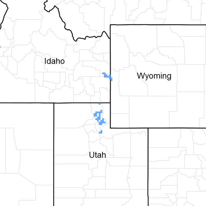
Figure 1. Mapped extent
Areas shown in blue indicate the maximum mapped extent of this ecological site. Other ecological sites likely occur within the highlighted areas. It is also possible for this ecological site to occur outside of highlighted areas if detailed soil survey has not been completed or recently updated.
MLRA notes
Major Land Resource Area (MLRA): 047X–Wasatch and Uinta Mountains
MLRA 47 occurs in Utah (86 percent), Wyoming (8 percent), Colorado (4 percent), and Idaho (2 percent). It encompasses approximately 23,825 square miles (61,740 square kilometers). The northern half of this area is in the Middle Rocky Mountains Province of the Rocky Mountain System. Parts of the western edge of this MLRA are in the Great Basin Section of the Basin and Range Province of the Intermontane Plateaus. The MLRA includes the Wasatch Mountains, which trend north and south. The steeply sloping, precipitous Wasatch Mountains have narrow crests and deep valleys. Active faulting and erosion are a dominant force in controlling the geomorphology of the area.
The mountains in this area are primarily fault blocks that have been tilted up. Alluvial fans at the base of the mountains are recharge zones for the basin fill aquifers. An ancient shoreline of historic Bonneville Lake is evident on the footslopes along the western edge of the area. Rocks exposed in the mountains are mostly Mesozoic and Paleozoic sediments.
The average precipitation is from 12 to 16 inches in the valleys and can range up to 73 inches in the mountains. Peak precipitation occurs in the winter months. The average annual temperature is 30 to 50 degrees Fahrenheit (-1 to 15 C). The freeze-free period averages 140 days and ranges from 60 to 220 days, generally decreasing in length with elevation.
The dominant soil orders in this MLRA are Entisols, Inceptisols, and Mollisols. The lower elevations are dominated by a frigid temperature regime, while the higher elevations experience cryic temperature regimes. The soil moisture regime is typically xeric. The minerology is generally mixed and the soils are very shallow to very deep, generally well drained, and loamy or loamy-skeletal.
Classification relationships
Modal Soil: Herd CB-L, 3-15% — fine, montmorillonitic Mollic Cryoboralfs
Ecological site concept
The soils of this site are deep, well-drained clay loams. Clay content tends to increase with increasing depth. They formed on mountain slopes and ridges in colluvium and slope alluvium derived from sandstone, conglomerate and/or quartzite parent materials. Cobbles and gravels may be present on the soil surface and account for no more than 20 percent of the soil volume. Permeability of water is moderately slow to slow and roots penetrate the soil readily. These soils are non-calcareous and neutral to slightly acidic. Available water capacity is 5.3 to 7.9 inches in the upper 40 inches of soil. The soil moisture regime is xeric udic and the soil temperature regime is frigid or cryic.
Associated sites
| R047XA516UT |
High Mountain Loam (mountain big sagebrush) |
|---|---|
| R047XA517UT |
High Mountain Loam (silver sagebrush) |
| R047XA528UT |
High Mountain Stony Clay (slender wheatgrass) |
Similar sites
| R047XA402UT |
Mountain Clay (slender wheatgrass) |
|---|---|
| R047XA528UT |
High Mountain Stony Clay (slender wheatgrass) The soils of this site have greater than 35% rock fragments by volume. It also typically occurs at high elevations than the high mountain clay site, up to 9,000 feet. |
| R047XA454UT |
Mountain Stony Clay (slender wheatgrass) The soil for this site has greater than 35% rock fragments by volume. It also recieves less annual precipitation than the high mountain clay site. |
Table 1. Dominant plant species
| Tree |
Not specified |
|---|---|
| Shrub |
Not specified |
| Herbaceous |
(1) Elymus trachycaulus |
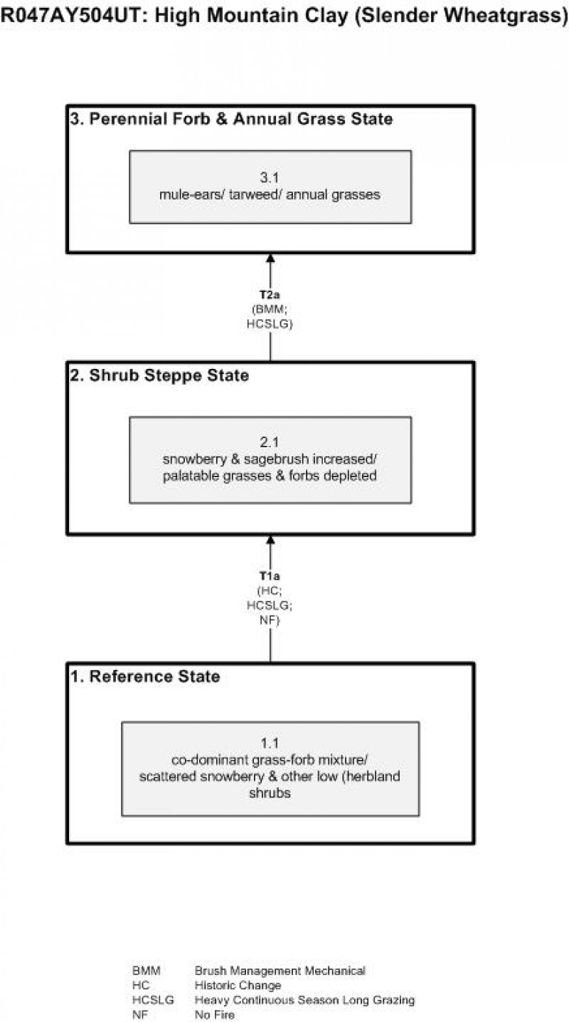
Click on box and path labels to scroll to the respective text.
| T1a | - | introduction of exotic species |
|---|---|---|
| T2a | - | Mechanical disturbance of woody species and continued heavy livestock grazing during the growing-season |