Ecological dynamics
It is impossible to determine in any quantitative detail the Historic Climax Plant Community (HCPC) for this ecological site because of the lack of direct historical documentation preceding all human influence. In some areas, the earliest reports of dominant plants include the cadastral survey conducted by the General Land Office, which began in the late 19th century for this area (Galatowitsch 1990). However, up to the 1870s the Shoshone Indians, prevalent in northern Utah and neighboring states, grazed horses and set fires to alter the vegetation for their needs (Parson 1996). In the 1860s, Europeans brought cattle and horses to the area, grazing large numbers of them on unfenced parcels year-long (Parson 1996). Itinerant and local sheep flocks followed, largely replacing cattle as the browse component increased.
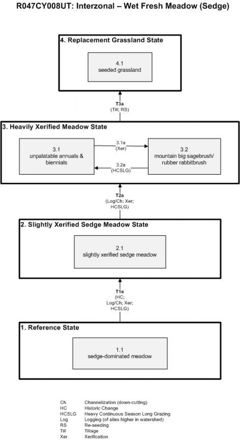
Below is a State and Transition Model diagram to illustrate the “phases” (common plant communities), and “states” (aggregations of those plant communities) that can occur on the site. Differences between phases and states depend primarily upon observations of a range of disturbance histories in areas where this ESD is represented. These situations include grazing gradients to water sources, fence-line contrasts, patches with differing dates of fire, herbicide treatment, tillage, etc. Reference State 1 illustrates the common plant communities that probably existed just prior to European settlement.
The major successional pathways within states, (“community pathways”) are indicated by arrows between phases. “Transitions” are indicated by arrows between states. The drivers of these changes are indicated in codes decipherable by referring to the legend at the bottom of the page and by reading the detailed narratives that follow the diagram. The transition between Reference State 1 and State 2 is considered irreversible because of the naturalization of exotic species of both flora and fauna, possible extinction of native species, and climate change. There may have also been accelerated soil erosion.
When available, monitoring data (of various types) were employed to validate more subjective inferences made in this diagram. See the complete files in the office of the State Range Conservationist for more details.
The plant communities shown in this State and Transition Model may not represent every possibility, but are probably the most prevalent and recurring plant communities. As more monitoring data are collected, some phases or states may be revised, removed, and/or new ones may be added. None of these plant communities should necessarily be thought of as “Desired Plant Communities.” According to the USDA NRCS National Range & Pasture Handbook (USDA-NRCS 2003), Desired Plant Communities (DPC’s) will be determined by the decision-makers and will meet minimum quality criteria established by the NRCS. The main purpose for including descriptions of a plant community is to capture the current knowledge at the time of this revision.
State 1
Reference State
The Reference State is a description of this ecological site just prior to Euro-American settlement but long after the arrival of Native Americans. The description of the Reference State was determined by NRCS Soil Survey Type Site Location information and familiarity with rangeland relict areas where they exist. The least modified plant community (1.1) within the Reference State would have been a fen (i.e. a wet grassland) dominated by sedges including Nebraska sedge (Carex nebrascensis), water sedge (Carex aquatilis), and smallwing sedge (Carex microptera), rushes including mountain rush (Juncus arcticus ssp. littoralis) and fewflower spikerush (Eleocharis quinqueflora), and grasses including tufted hairgrass (Deschampsia cespitosa), alpine timothy (Phleum alpinum), marsh bluegrass (Poa leptocoma), and slender wheatgrass (Elymus trachycaulus). Minor amounts of forbs and shrubs would have also occurred. A more complete list of species by lifeform for the Reference State is available in accompanying tables in the “Plant Community Composition by Weight and Percentage” section of this document.
The productivity and composition of this plant community would have been quite stable, although varying with the climate because it would have been affected by runoff from streams originating at higher elevations in adjacent mountains. The water table usually persisted throughout the year, causing poorly-aerated soils. Following very wet winters, the melting snow pack would have caused a high and widespread surge of flooding.
Community 1.1
Reference Plant Community
Community Phase 1.1: sedge-dominated meadow
The Reference State would have been a meadow dominated by several species of sedge including Nebraska sedge, water sedge, and smallwing sedge. Some rushes (mountain rush and fewflower spikerush) and grass species (tufted hairgrass, alpine timothy, marsh bluegrass, and slender wheatgrass) would have also been present.
Table 5. Annual production by plant type
| Plant type |
Low
(lb/acre) |
Representative value
(lb/acre) |
High
(lb/acre) |
| Grass/Grasslike |
3105 |
4454 |
5804 |
| Forb |
173 |
248 |
323 |
| Shrub/Vine |
173 |
248 |
323 |
| Total |
3451 |
4950 |
6450 |
Table 6. Ground cover
| Tree foliar cover |
0%
|
| Shrub/vine/liana foliar cover |
0-2%
|
| Grass/grasslike foliar cover |
89-91%
|
| Forb foliar cover |
4-6%
|
| Non-vascular plants |
0%
|
| Biological crusts |
0%
|
| Litter |
0%
|
| Surface fragments >0.25" and <=3" |
0%
|
| Surface fragments >3" |
0%
|
| Bedrock |
0%
|
| Water |
0%
|
| Bare ground |
0%
|
Table 7. Canopy structure (% cover)
| Height Above Ground (ft) |
Tree |
Shrub/Vine |
Grass/
Grasslike |
Forb |
| <0.5 |
– |
– |
– |
– |
| >0.5 <= 1 |
– |
– |
– |
4-6% |
| >1 <= 2 |
– |
– |
89-94% |
– |
| >2 <= 4.5 |
– |
– |
– |
– |
| >4.5 <= 13 |
– |
– |
– |
– |
| >13 <= 40 |
– |
– |
– |
– |
| >40 <= 80 |
– |
– |
– |
– |
| >80 <= 120 |
– |
– |
– |
– |
| >120 |
– |
– |
– |
– |
State 2
Slightly Xerified Sedge Meadow State
State 2 is similar to State 1 in form and function, with the exception of the presence of non-native plants and animals, possible extinctions of native species, and a different climate. State 2 is a description of the ecological site shortly following Euro-American settlement. This state can be regarded as the current potential. Although similar to State 1 in form and function, soon after European colonization, this xerified state saw reductions in the proportion of the finer-textured soils, and thus a decrease in the more palatable, grasses and increases in the coarser sedges and rushes. Because the soils are somewhat drier due to changes in the hydrologic regime, expansion of native shrubs such as Geyer willow (Salix geyeriana), Woods’ rose (Rosa woodsii), and cinquefoil (Potentilla spp.) began. In areas first targeted by the U.S. Forest Service for grazing control (circa 1910), the herbaceous fraction usually regained its dominance and slowed down the advance of the shrubs. An increase in moose and beaver also put pressure on the willows. Newly constructed beaver dams simultaneously increased ponding and raised water tables in and around streams.
Community 2.1
Slightly Xerified Sedge Meadow Plant Community
This plant community is dominated by the less palatable sedges and rushes with patches of native shrubs including Geyer willow, Woods’ rose, and cinquefoil.
State 3
Heavily Xerified Meadow State
Where control of grazing intensity hadn’t been achieved earlier and excessive use by livestock prevailed, the vegetation takes on the character of drier sites at low elevations. Upland species such as rubber rabbitbrush (Ericameria nauseosa) and mountain big sagebrush (Artemisia tridentata ssp. vaseyana), common on drier adjacent sites, begin to dominate (3.2). The areas most heavily affected from livestock grazing and loafing (3.2a) will be reduced to only those annual and biennial species most tolerant to disturbance (3.1).
Community 3.1
Unpalatable Annuals & Biennials Plant Community
Community Phase 3.1: unpalatable annuals & biennials
This plant community is dominated by a mixture of native and introduced annuals and biennials such as Douglas' knotweed (Polygonum douglasii), mountain tarweed (Madia glomerata), common dandelion (Taraxacum officinale), curlycup gumweed (Grindelia squarrosa), povertyweed (Iva axillaris), and Fuller’s teasel (Dipsacus fullonum). Disturbance has been so frequent and heavy that long-lived plants have no chance to become dominant. This vegetation will persist until impacts are diminished.
Community 3.2
Mountain big sagebrush/ rubber rabbitbrush Plant Community
Community Phase 3.2: mountain big sagebrush/ rubber rabbitbrush
With a lessening of the frequency and intensities of disturbance, shrubs that dominate adjacent drier sites can invade the site and become dominant. Rubber rabbitbrush is an early invader; however mountain big sagebrush will eventually come to dominate.
Pathway 3.1a
Community 3.1 to 3.2
Previous channelization and consequent lowering of the water table will over time lead to xerification of this site. This occurs due to changes in the hydrologic and soil moisture regimes and allows shrubs to become more dominant.
Pathway 3.2a
Community 3.2 to 3.1
Heavy and frequent disturbance over a prolonged period of time will convert the site to one dominated by shorter-lived and unpalatable forb species.
State 4
Replacement Grassland State
Grasses used to reseed degraded montane meadows include meadow foxtail, tall oatgrass (Arrhenatherum elatius), mountain brome (Bromus marginatus), orchardgrass (Dactylis glomerata), tufted hairgrass, sheep fescue (Festuca ovina), meadow barley (Hordeum brachyantherum), and timothy (Phleum pratense) (4.1). Smooth brome (Bromus inermis) was commonly seeded in the past, but should be avoided because of its invasive nature. No matter the seed mix used, there will be some seed remaining in the tilled soil and subsequent climate and management will mold the species occurring at particular times. These variables make it impossible to anticipate the phases that will develop. Monitor changes and regulate use to favor the species combinations desired.
Community 4.1
Replacement Grassland Plant Community
Community Phase 4.1: seeded grassland
This plant community is dominated by a suite of seeded montane grass species used to increase forage production for livestock. A combination of any of the following species may be present: meadow foxtail, tall oatgrass, California brome, meadow brome, mountain brome, smooth brome, orchardgrass, tufted hairgrass, sheep fescue, meadow barley, and timothy.
Transition T1a
State 1 to 2
Transition from State 1 to State 2 (Reference State to Slightly Xerified Sedge Meadow State)
The simultaneous introduction of exotic species, both plants and animals, and possible extinctions of native flora and fauna, along with climate change, impacted the Reference State. However, it was primarily the heavy logging and livestock grazing in the watersheds above that changed the environment in this ESD. Those activities led to earlier and higher floods following snowmelt. These waters also carried more sediment and caused more rapid down-cutting of the stream courses. This lowered the water table and shortened the period of soil saturation. Direct livestock utilization disfavored the fine textured grasses and grass-likes, allowing an increase in the proportion of sedges and rushes with higher silica content.
Reversal of these historic changes (i.e. a return pathway back to State 1) is not practical.
Transition T2a
State 2 to 3
T2a: Transition from State 2 to State 3 (Slightly Xerified Sedge Meadow State to Heavily Xerified Meadow State)
These meadows are indirectly affected by the logging and livestock grazing pressures that occur in forested areas higher in the watershed. Where heavy logging and livestock grazing is not controlled, flash-flooding results, causing an increase in sediment-loads down the connecting streams. Streambanks are down-cut, causing the flow of water through these lower montane meadows to increase. Where heavy grazing pressure continues directly on these drying meadows, further xerification results these sites becoming invaded by both native and introduced species tolerant of drier soils and greater disturbance. The approach to this transition is indicated by the occurrence of seedlings of species dominant on drier sites, by areas of frequent disturbance, and by reduced ground cover.
Transition T3a
State 3 to 4
Transition from State 3 to State 4 (Heavily Xerified Meadow State to Replacement Grassland State)
This transition is triggered by management decisions and actions. Because forage production is so diminished from earlier States and the hydrological regime so modified, it is impractical to reseed with species present in the Reference State or State 2. Thus, it has been common to till and re-seed with introduced species to regain a higher level of ground cover and forage production.