Natural Resources
Conservation Service
Ecological site R062XY002SD
Wet Land
Last updated: 2/06/2025
Accessed: 05/10/2025
General information
Provisional. A provisional ecological site description has undergone quality control and quality assurance review. It contains a working state and transition model and enough information to identify the ecological site.
MLRA notes
Major Land Resource Area (MLRA): 062X–Black Hills
The Black Hills (MLRA 62) is a unique, low lying mountain range situated in the midst of a mixed short and mid-grass prairie. It is a true Island in the Plains, as it has geophysical and biological attributes that are unlike the surrounding area. The Black Hills have strong floristic ties to four of the North American biomes: Cordilleran (Rocky Mountain) Forest, Northern Coniferous Forest, Eastern Deciduous Forest, and Grasslands.
MLRA 62 is approximately 3,040 square miles in size; 74 percent is located in South Dakota, and 26 percent is in Wyoming. The towns of Lead, Deadwood, Hill City, and Custer, South Dakota, are in this area. U.S. Highways 16 and 385 cross the MLRA. The Black Hills National Forest, Custer State Park, Mt. Rushmore National Monument, Wind Cave National Park, and Jewel Cave National Monument are located in this MLRA.
This area forms the core of the Black Hills and the Bear Lodge Mountains where the elevation ranges between 3,600 to 6,565 feet, however, Black Elk Peak (Harney Peak) rises to 7,242 feet. Slopes range from moderately sloping on some of the high plateaus to very steeply sloping along drainageways and on peaks and ridges. Narrow valleys generally are gently sloping to strongly sloping.
The Black Hills uplift is the product of the Laramide mountain-building episodes that produced most of the ranges in the Rocky Mountains. Uplift began near the end of the Cretaceous period, 65 million years ago and ended by 35 million years ago (Froiland 1990). The core of the Black Hills is a plutonic mass of granite with steeply dipping metamorphic rocks, primarily slate and schist, directly surrounding the granite core. A plateau of Mississippian limestone surrounds the igneous and metamorphic rock core. The Madison limestone is broken around the outer edges of the uplifted area. The Permian Minnekahta limestone forms the outermost boundary of the area. Many other tilted sandstone, shale, and limestone units are exposed like a bathtub ring inside the steeply dipping Madison limestone.
The dominant soil orders in this MLRA are Alfisols (forest soils) and Mollisols (grassland soils). The soils in the area have a frigid or cryic soil temperature regime, a udic or ustic soil moisture regime, and mixed, micaceous, or smectitic mineralogy. They are shallow to very deep, generally well drained, and loamy in texture.
The Black Hills MLRA supports open to dense forest vegetation. Ponderosa pine is the dominant species across the Black Hills. White spruce grows at the higher elevations and along the major drainageways. Bur oak is found intermixed with pine in the northern and eastern fringes of the Black Hills, and Rocky Mountain juniper is more common in the southern portion of the Black Hills. Aspen and paper birch are minor components found throughout the Black Hills. Prairie dropseed, roughleaf ricegrass, green needlegrass, poverty oatgrass, Richardson’s needlegrass, slender wheatgrass, and Canada wildrye are the most common native grasses under open forest stands. The most common native shrubs are bearberry, common juniper, grouse whortleberry, poison ivy, and Saskatoon serviceberry.
MLRA 62 land ownership is approximately 47 percent private and 53 percent federal. Rangeland and forestland are split almost equally between private and federal ownership (47 percent each). Minor areas of land are privately owned cropland and urban development. The forestland in this area is used mainly for timber production, recreation, and grazing.
The major resource concerns are soil erosion and surface compaction caused by logging, mining, wildfires, grazing, and urban expansion. The quality of ground and surface water is another concern, especially in the northern part of the Black Hills. The primary cause is contamination from mine waste and septic systems in areas of rural development and urban expansion (USDA-NRCS, 2006: Ag Handbook 296).
LRU notes
For development of ecological sites, MLRA 62 is divided into three LRU’s or physiographic zones (A, B, C, and Y). Each LRU has a set of ecological sites that represents these zones.
The LRU is identified in the Ecological Site ID: R062XY000SD; “062X” identifies the MLRA, the next letter “Y” identifies the LRU. Note: The organization of Ecological Site ID’s will likely change in the future.
The North, LRU-A includes the northern Black Hills and Bear Lodge Mountains. It receives between 22 and 30 inches of annual precipitation and has a frigid soil temperature regime.
The High Central, LRU-B includes the high elevation (> 6,200 feet) central core of the Black Hills, which receives between 25 to 35 inches of annual precipitation and has a cryic soil temperature regime.
The South, LRU-C includes the southern portion of the Black Hills and receives between 17 to 21 inches of annual precipitation and has a frigid soil temperature regime.
One additional grouping of ecological sites that are common to the entire MLRA are designated with a “Y” in the ecological site ID.
Classification relationships
USDA
Land Resource Region G—Western Great Plains Range and Irrigated Region:
Major Land Resource Area (MLRA) 62—Black Hills
US Environmental Protection Agency (EPA)
Level IV Ecoregions of the Conterminous United States:
Black Hills Plateau—17b
Black Hills Core Highlands—17c
USDA Forest Service
Ecological Subregions: Sections and Subsections of Conterminous United States:
Black Hills Coniferous Forest Province—M334:
Black Hills Section—334A
Black Hills Limestone Plateau-Core Highlands Subsection—M334Ab
Ecological site concept
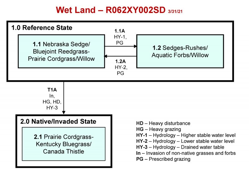
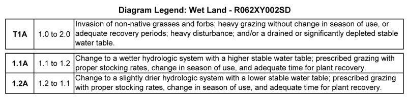
The Wet Land ecological site is found throughout MLRA 62. It is a run-in site located in nearly level valleys near springs, seeps, and sloughs or other areas of flooding and ponding. Slopes range from 0 to 3 percent. The soils are very deep, very poorly drained and formed in alluvium. A surface A-horizon will range between 5 and 14 inches in depth with silt loam surface textures. An O-horizon may occur, consisting of peat or decomposed plant material that is 2-foot or greater in depth.
Vegetation in Reference State (1.0) consists of grass-likes, grasses, forbs, and scattered dense patches of shrub. All are adapted to and can tolerate wet soil conditions or are classified as wetland obligate or facultative wet species.
Associated sites
| R062XY005SD |
Wet Subirrigated The Wet Subirrigated ecological site is found adjacent to and intermixed with Wet Land ecological site. The Wet Subirrigated ecological site will have a permanent water table at 1 to 2 feet of the surface. |
|---|---|
| R062XY003SD |
Subirrigated The Subirrigated ecological site is found adjacent to the Wet Land ecological site. The Subirrigated ecological site will have a seasonally water table within 2 to 5 feet of the surface. |
Similar sites
| R062XY005SD |
Wet Subirrigated The Wet Subirrigated ecological site is found on similar landscape positions as the Wet Land site. The Wet Subirrigated site will have a permanent water table at 1 to 2 feet. The Wet Subirrigated plant community will have more prairie cordgrass, and fewer obligate grass-like species and forbs than the Wet Land ecological site. |
|---|---|
| R062XY003SD |
Subirrigated The Subirrigated ecological site is found on similar landscape positions as the Wet Land site. The Subirrigated site will have a seasonal water table at 2 to 5 feet. The Subirrigated plant community will have more bluestem, less prairie cordgrass, and fewer obligate grass-like species and forbs than the Wet Land ecological site. |
Table 1. Dominant plant species
| Tree |
Not specified |
|---|---|
| Shrub |
(1) Salix bebbiana |
| Herbaceous |
(1) Carex nebrascensis |
Click on box and path labels to scroll to the respective text.