Natural Resources
Conservation Service
Ecological site R065XY041NE
Shallow To Gravel
Last updated: 2/04/2025
Accessed: 05/11/2025
General information
Provisional. A provisional ecological site description has undergone quality control and quality assurance review. It contains a working state and transition model and enough information to identify the ecological site.
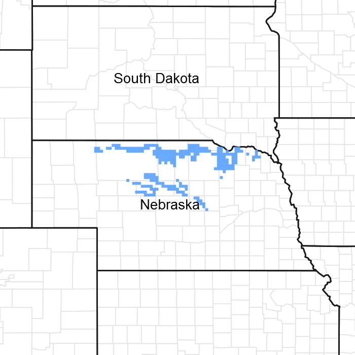
Figure 1. Mapped extent
Areas shown in blue indicate the maximum mapped extent of this ecological site. Other ecological sites likely occur within the highlighted areas. It is also possible for this ecological site to occur outside of highlighted areas if detailed soil survey has not been completed or recently updated.
MLRA notes
Major Land Resource Area (MLRA): 065X–Nebraska Sand Hills
The Nebraska Sand Hills (MLRA 65) is located in Nebraska (98 percent) and South Dakota (2 percent) and encompasses approximately 13.2 million acres (534,201 hectares) or 20,625 square miles (53,420 square kilometers). The largest town in the MLRA is North Platte, Nebraska and numerous small towns and villages are located within the MLRA, including the county seats of Arthur, Bartlett, Bassett, Brewster, Greeley, Hyannis, Mullen,
Thedford, and Tryon, Nebraska. The Niobrara River is near the northern boundary while the North Platte River flows along the southwest boundary of the area. The North Loup, Middle Loup Rivers, Calamus, Snake, and Dismal Rivers and Long Pine creek occur in the central and eastern portion of the area.
Fort Niobrara, Crescent Lake, and Valentine National Wildlife Refuges and portions of the Nebraska National Forest, including the Bessey Ranger District and Samuel R. McKelvie National Forest, are located within this MLRA. The Bessey Ranger District includes the largest human-planted forest in the United States and is home to the Bessey Tree Nursery which is listed on the National Register of Historic Places.
This MLRA is defined by an 8,000 year-old landscape of sand hills dominated by rolling to steep sand dunes with narrow, elongated, nearly level to steeply sloping valleys between the dunes. Dune heights range from 10 to 400 feet (3 to 130 meters) and slopes may exceed twenty-five percent. Dune complexes often extend for several miles in a northwest to southeast direction. These Quaternary sand dunes are derived from the underlying Tertiary Ogallala and Arikaree Groups, which formed when rivers deposited sediments from erosional detritus after the uplift of the Rocky Mountains to the west. The Nebraska Sand Hills are the largest sand dune area in the Western Hemisphere and one of the largest grass-stabilized dune regions in the world. The soils of the MLRA are principally derived from deep eolian sand.
The Ogallala aquifer underlies the MLRA and is the most extensive and heavily used aquifer of the high plains between the Rocky Mountains and Mississippi River. The aquifer is at its thickest in the Sand Hills which are a primary recharge are for the aquifer. Numerous small permanent and intermittent lakes and wetlands occur in the MLRA. While the dominant source of water for these lakes is precipitation, groundwater discharge is important to maintaining these lakes especially in drier years. A number of these lakes, especially in the western portion of the MLRA are alkaline.
Considered to be a western extension of the tallgrass prairie, the matrix vegetation is a unique mix of species that is sometimes identified as Sandhills Prairie. Sand bluestem, prairie sandreed, Indiangrass, switchgrass, sand lovegrass, little bluestem, and needle and thread are the primary grasses. Porcupinegrass is a significant cool-season grass in the eastern portion of the MLRA while blue grama and hairy grama are important warm-season grasses in the western portion due to differences in precipitation. Soils which have a high water table support a tallgrass prairie dominated by big bluestem, switchgrass, Indiangrass, prairie cordgrass, and a variety of grass-likes. The endangered plant blowout penstemon (Penstemon haydenii) is found in this MLRA.
More than ninety percent of the land in MLRA 65 is native grassland utilized by grazing livestock. Areas along streams and in subirrigated valleys are utilized for prairie hay. Wetlands, legume hay, and irrigated cropland make up the balance of the land area with corn being the principal irrigated crop.
Wildlife flourishes in this native grassland environment. Historically large bison herds occupied the landscape. White-tailed deer, mule deer, pronghorn, black tailed jackrabbit, and coyote are now the major mammalian species. Upland sandpiper, lark bunting, grasshopper sparrow, western meadowlark, long-billed curlew, sharp-tailed grouse, and greater prairie chicken are common avian species. The mosaic of grassland and wetlands provide excellent habitat for wading and shorebird species as well.
This landscape serves as a backdrop for a disturbance-driven ecosystem, which developed under the influences of herbivory, fire, and periodic long-term drought. Historically, these processes created a heterogeneous mosaic of plant communities and vegetative structure across the region. Any given site in this landscape experienced fire every six to ten years. Fires were caused by lightning strikes and also were set by Native Americans, who used fire for warfare, signaling, and to refresh the native grasses. Indigenous peoples understood the value of fire as a tool and that the highly palatable growth following a fire provided excellent forage for their horses and attracted grazing animals such as bison, elk, and pronghorn.
The natural fire regime has been disrupted by aggressive fire suppression policies which have facilitated woody species encroachment by both native and introduced shrubs and trees into the native prairie. The most common encroacher is eastern redcedar. While eastern redcedar is native to the landscape, it was present only in trace amounts due to the periodic fires. Widespread plantings of windbreaks with eastern redcedar as a primary component have provided a seed source for this aggressive woody plant causing encroachment into native grasslands, especially in the eastern and central Sand Hills. This encroachment causes significant forage loss for domestic livestock and degrades the native wildlife habit. Since it is not a root-sprouter, eastern redcedar is very susceptible to fire when under six feet tall making management with prescribed fire very effective when applied before trees reach this stage.
Classification relationships
►USDA-NRCS (2022)◄
Land Resource Region – G, Central Feed Grains and Livestock Region
Major Land Resource Area (MLRA) –65, Nebraska Sand Hills
►Fenneman (1916) Physiographic Regions ◄
Division – Interior Plains
Province – Great Plains
Section – High Plains
►USDA-USFS (2007) Ecoregions◄
Domain – Dry
Division – Temperate Steppe
Province – Great Plains Steppe (332)
Section – Mixed Grass Steppe
►EPA Ecoregions (Omernik 1997)◄
I – Great Plains (9)
II – West-Central Semi-Arid Prairies (9.3)
III – Nebraska Sandhills (44)
IV – Sandhills (44a), Alkaline Lakes Area (44b), Wet Meadow and Marsh Plain (44c), Lakes Area (44d)
Ecological site concept
The Shallow to Gravel ecological site is a run-off site occurring on hills and stream terraces. Slopes range from 0 to 30 percent. The soils very deep. and formed primarily in loamy or sandy alluvium over sandy and gravelly alluvium and outwash. Soil surface layers typically range in thickness from 5 to 7 inches, but may be as thick as 14 inches. The most significant characteristic of the Shallow to Gravel ecological site is the presence of more than 15 percent gravel in the top 20 inches of the soil.
The historic native vegetation of the Shallow to Gravel ecological site is mixed grass prairie. Vegetation in the Reference Community (1.1) consists of a mixture of warm- and cool-season grasses. Dominant grasses include sand bluestem, prairie sandreed, needle and thread, and blue grama. Forb and shrub diversity is low as compared to other ecological sites found in the MLRA. Lesser spikemoss is a common cryptogram on this site.
Associated sites
| R065XY011NE |
Sandy 14-17" PZ The Shallow to Gravel ecological site is often found interspersed with Sandy 14-17" PZ ecological sites. |
|---|---|
| R065XY032NE |
Sandy 17-22" PZ The Shallow to Gravel ecological site is often found interspersed with Sandy 17-22" PZ ecological sites. |
| R065XY054NE |
Sandy 22-25" PZ The Shallow to Gravel ecological site is often found interspersed with Sandy 22-25" PZ ecological sites. |
Similar sites
| R065XY032NE |
Sandy 17-22" PZ The soil surface textures of Sandy 17-22" PZ sites have less than 15 percent gravel in the top 20 inches of the soil. |
|---|---|
| R065XY054NE |
Sandy 22-25" PZ The soil surface textures of Sandy 22-25" PZ sites have less than 15 percent gravel in the top 20 inches of the soil. |
| R065XY011NE |
Sandy 14-17" PZ The soil surface textures of Sandy 14-17" PZ and Shallow to Gravel ecological sites are similar, but Sandy 14-17" PZ sites have less than 15 percent gravel in the top 20 inches of the soil. |
Table 1. Dominant plant species
| Tree |
Not specified |
|---|---|
| Shrub |
Not specified |
| Herbaceous |
(1) Andropogon hallii |
Click on box and path labels to scroll to the respective text.
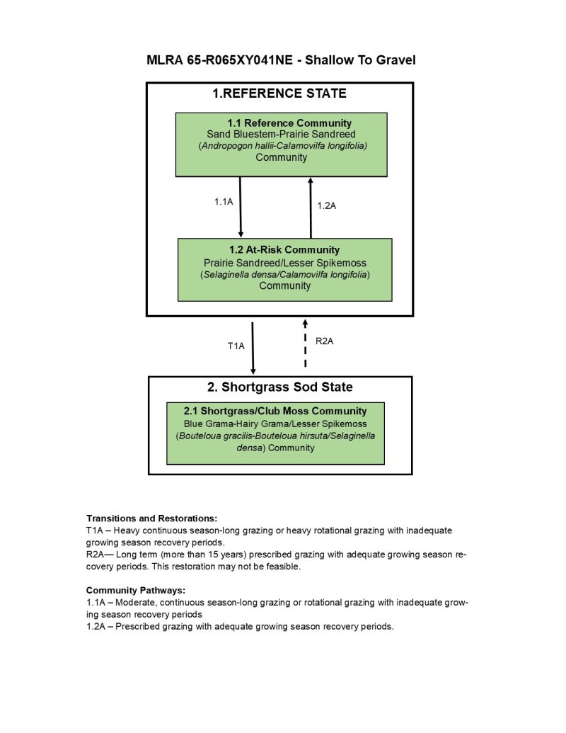
Ecosystem states
| T1A | - | Heavy continuous season-long grazing or heavy rotational grazing with inadequate growing season recovery periods. |
|---|---|---|
| R2A | - | Long term (more than 15 years) prescribed grazing with adequate growing season recovery periods. This restoration may not be feasible. |
State 1 submodel, plant communities
| 1.1A | - | Moderate, continuous season-long grazing or rotational grazing with inadequate growing season recovery periods |
|---|---|---|
| 1.2A | - | Prescribed grazing with adequate growing season recovery periods. |