Ecological dynamics
The information presented in this ecological site description (ESD) and state-and-transition model (STM) were developed using archaeological and historical information, published and unpublished scientific reports, professional experience, consultation with technical experts, and NRCS inventories and studies. The information presented represents a complex set of plant community dynamic and environmental variables. Not all scenarios or plants are represented and included. Key indicator plants, animals, and ecological processes are described to help guide land management decisions and actions.
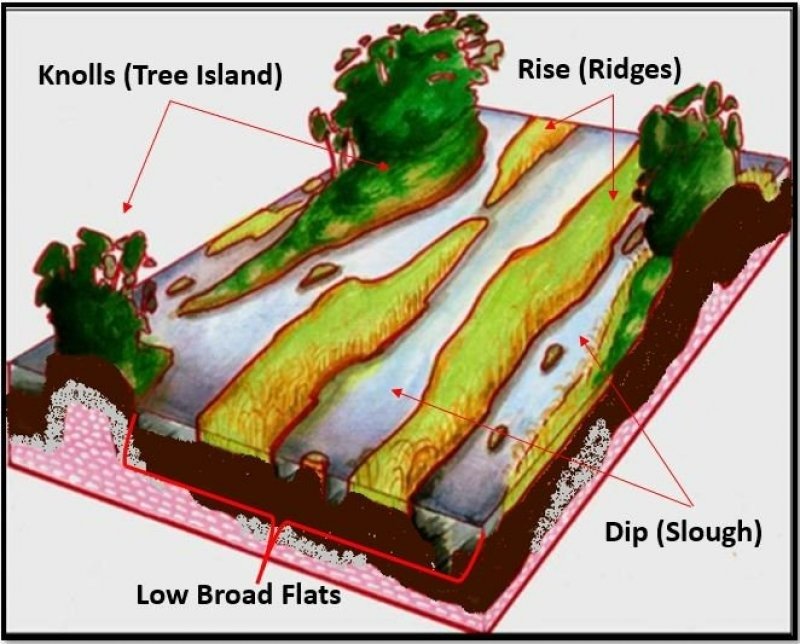
The Subtropical Freshwater Forested Wetland of the Everglades are isolated areas of mineral soil or organic materials on knolls (Tree Islands) above the sawgrass prairie that have shorter hydroperiods and are subject to frequent flooded conditions (3 weeks [8 to 30 cm (3 to 12")]) that support hardwood and “dry” tree islands vegetation. A heavy canopy closure, causing deep interior shade, is prevalent. These conditions contribute with the control of the temperature and moisture retention. The vegetation is dense, heavy, strong wood, and shallow spreading root system which adapt them to harsh wind, periodic droughts and flooding conditions.
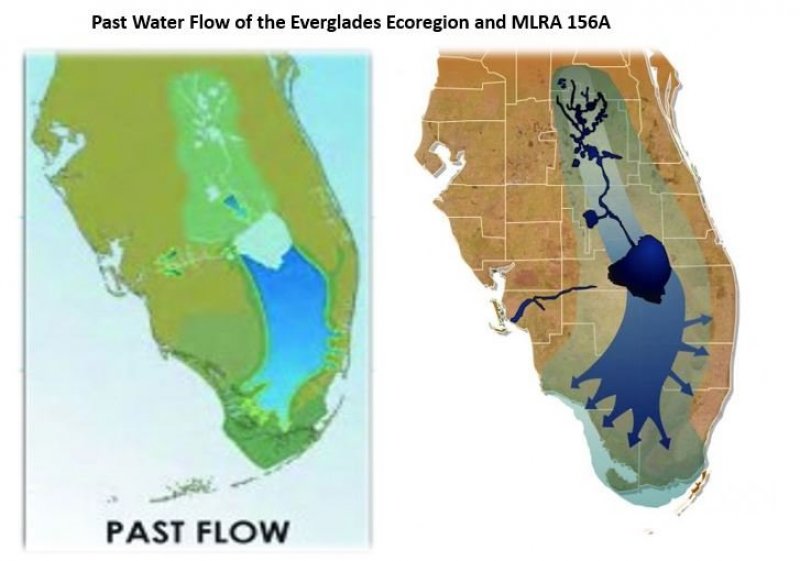
The Subtropical Freshwater Forested Wetland of the Everglades mainly occurs in the Florida peninsula of the Everglades, and probably do not occur north of Lake Okeechobee. The extent covers Palm Beach County, Collier County, Monroe County, Broward County, and Miami-Dade County with only small occurrences further west immediately adjacent to salt marshes. It is less widespread on the east coast but may be found on the St. John’s River floodplain and just inland of salt marshes along the northeastern coast.
Natural Process:
Hydric Hammock; short hydroperiods and flooding frequency are the primary factors in species composition. While most hydric hammock trees are at least somewhat adapted to flooding, the ranges of tolerance vary according to timing and depth of inundation. Fire is not considered an important component of hydric hammock dynamics; however, they do burn occasionally.
Strands Swamps; longer hydroperiods and fire occurs rarely in strand swamps, with the largest trees on the deepest peat towards the center of the strand burning least frequently. However, fires from surrounding sawgrass marsh communities can frequently burn into the outer edges of strand swamps. In this way, occasional fire contributes to the maintenance of a cypress dominated community. Cypress is very tolerant of light surface fires, but muck fires burning into the peat can kill the trees and lower the ground surface, transforming a strand swamp into a slough. Where severe fires have killed cypress, coastal plain willow commonly establishes as a thicket.
Baygall; short hydroperiods and flooding frequency are the primary factors in species composition. Leaf litter accumulation raises the soil level, allowing bay species that require a shorter hydroperiod to become established. As the broad-leaved species proliferate, the shade-intolerant cypress and swamp tupelo seedlings are inhibited, shifting vegetation and soil conditions to favor broadleaf species that can germinate and grow in low light. The dominant baygall species are fire-intolerant, and a mature canopy indicates the lack of destructive fire for many years. Although the saturated soils and humid conditions within baygalls typically inhibit fire, droughts may create conditions that allow them to burn catastrophically. These fires not only destroy the canopy, but also may ignite the deep peat layers that can smolder for weeks, or even months. This occurs perhaps only a few times each century in the deepest baygalls. Where the peat layer is destroyed, the lower soil level may collect open water that can be re-colonized by marsh or cypress swamp vegetation.
Thus, certain vegetation types (baygall, basin swamp, shrub bog, and open water) have been described as a “moving mosaic” of vegetation determined by fire history and hydrology. In South Florida bayheads, severe fires that consume the peat can convert a bay-dominated forest to a lower thicket of coastalplain willow (Salix caroliniana).
State 1
Forested Wetlands (Tree Islands)
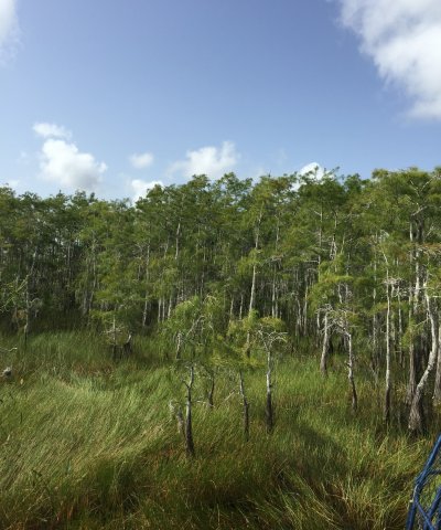
Figure 16. Tree Island in WCA 2, seen from airboat travelling through sawgrass marsh. From a distance these often appear as densely vegetated areas with sparse trees growing out along the periphery. This island is dominated by cypress.
These occur as isolated areas of mineral soil or organic materials on knolls which support freshwater forested wetland species. These are the "Tree Islands" seen throughout the Everglades that rise above the sawgrass prairies and are subject to frequent flooding conditions during the wet season. They are dominated by a heavy canopy closure, causing deep interior shade, which help control the temperature and moisture retention. The vegetation is dense, heavy, strong wood, and shallow spreading root systems which adapt these species to harsh wind, periodic droughts, fire, and flooding conditions.
It is important to note there are multiple vegetative communities that may exist as tree islands (expressed in the submodel). They are all included in one ESD due to the similar management considerations, flooding frequency, soil components, geomorphic positions, and mapping constraints which may be amended with a higher detail survey in future projects.
Characteristics and indicators. These are the tree islands which rise above the landscape within the Everglades ecoregion. They are generally small in size and orientated in a north south direct in aerial images. During the dry season (November to June) the island may be completely dry and support understory vegetation. During the wet season, the surrounding sawgrass marshes may create flooding conditions which submerge the understory of these islands. These are highly protected communities and hold high cultural importance with the local Native American tribes.
Resilience management. Resilience for these communities is dependent on the specific vegetative community (described in the submodel). However, extended hydroperiods and fire frequency and intensity are the two most important factors in this environment. Extended hydroperiods may cause erosion problems to the mineral islands, destroying this community. Extreme fires may destroy the organic islands, with the absence of fire allowing expansion of the community. Typically once a mineral island is destroyed it cannot be restored, but may be replaced by an organic island (baygall / willow head). Hydrologic management would need to be addressed from the source of flooding, the extensive canals and ditches used to drain the Everglades Agricultural Areas immediately adjacent off the south side of Lake Okeechobee.
Dominant plant species
-
coastal plain willow (Salix caroliniana), tree
-
coco plum (Chrysobalanus icaco), tree
-
bald cypress (Taxodium), tree
-
Florida strangler fig (Ficus aurea), tree
-
pond apple (Annona glabra), tree
-
live oak (Quercus virginiana), tree
-
cabbage palmetto (Sabal palmetto), tree
-
false tamarind (Lysiloma latisiliquum), tree
-
Florida fishpoison tree (Piscidia piscipula), tree
-
false mastic (Sideroxylon foetidissimum), tree
-
common buttonbush (Cephalanthus occidentalis), tree
-
island marlberry (Ardisia escallonoides), shrub
-
West Indian milkberry (Chiococca alba), shrub
-
Seminole balsamo (Psychotria nervosa), shrub
-
panicgrass (Panicum), grass
-
hilograss (Paspalum conjugatum), grass
-
Jamaica swamp sawgrass (Cladium mariscus ssp. jamaicense), grass
-
airplant (Tillandsia), other herbaceous
-
inland leatherfern (Acrostichum danaeifolium), other herbaceous
-
polypody (Polypodium), other herbaceous
Dominant resource concerns
-
Wind erosion
-
Bank erosion from streams, shorelines, or water conveyance channels
-
Subsidence
-
Organic matter depletion
-
Seasonal high water table
Community 1.1
Hydric Hammock Tree Islands
These are evergreen, hardwood, and / or palm forests with a variable understory typically dominated by palms and ferns occurring on moist mineral soils, often with limestone very near the surface. While species composition varies, the community generally has a closed canopy of oaks and palms, and open understory, and a sparse to a moderate groundcover of grasses and ferns.
The species composition is mainly influenced by flooding patterns. In saturated and frequently flooded environments, more hydrophytic trees become more abundant. Frequency and depth of inundation have a pronounced effect on oak canopy composition as well, with saturated soils supporting more swamp laurel oak, and areas of infrequent flooding supporting more live oak. Flooding conditions contribute to hydric conditions and sapric organic material retention. Soils are variable, usually somewhat acidic to slightly alkaline with sapric organic matter, and mineral soils materials overlie a layer of Oligocene limestone near the surface and in some case deeper than 204 cm.
Forest overstory. The canopy is dominated by swamp laurel oak (Quercus laurifolia) and/or live oak (Q. virginiana) with varying amounts of cabbage palm (Sabal palmetto), American elm (Ulmus americana), sweetbay (Magnolia virginiana), red cedar (Juniperus virginiana), red maple (Acer rubrum), sugarberry (Celtis laevigata), sweetgum (Liquidambar styraciflua), and water oak (Q. nigra). Cabbage palm is a common to dominant component of hydric hammock throughout most of Florida. Loblolly pine (Pinus taeda) may be frequent in some areas, but slash pine (Pinus elliottii) is less frequently encountered.
Forest understory. In addition to saplings of canopy species, the understory may contain a number of small trees and shrubs. American hornbeam (Carpinus caroliniana) is often frequent, and various other woody species may be present including swamp dogwood (Cornus foemina), small-leaf viburnum (Viburnum obovatum), common persimmon (Diospyros virginiana), swamp bay (Persea palustris), wax myrtle (Myrica cerifera), dwarf palmetto (Sabal minor), American beautyberry (Callicarpa americana), and needle palm (Rhapidophyllum hystrix). Vines may be frequent and diverse; common species are eastern poison ivy (Toxicodendron radicans), peppervine (Ampelopsis arborea), rattan vine (Berchemia scandens), trumpet creeper (Campsis radicans), climbing hydrangea (Decumaria barbara), yellow jessamine (Gelsemium sempervirens), greenbriers (Smilax spp.), summer grape (Vitis aestivalis), and muscadine (Vitis rotundifolia). Herb cover, when present includes mostly graminoids and ferns with the following species commonly encountered: sedges (Carex spp.), woodoats (Chasmanthium spp.), smooth elephantsfoot (Elephantopus nudatus), Carolina scalystem (Elytraria caroliniensis), woodsgrass (Oplismenus hirtellus), maiden ferns (Thelypteris spp.), cinnamon fern (Osmunda cinnamomea), royal fern (Osmunda regalis var. spectabilis), toothed midsorus fern (Blechnum serrulatum), netted chain fern (Woodwardia areolata), and Virginia chain fern (Woodwardia virginica). Epiphytes such as golden polypody (Phlebodium aureum), air-plants (Tillandsia spp.), and shoestring fern (Vittaria lineata) increase in frequency to the south along with other more subtropical shrubs such as myrsine (Rapanea punctata), and wild coffee (Psychotria nervosa).
Dominant plant species
-
laurel oak (Quercus laurifolia), tree
-
live oak (Quercus virginiana), tree
-
cabbage palmetto (Sabal palmetto), tree
-
American elm (Ulmus americana), tree
-
sweetbay (Magnolia virginiana), tree
-
eastern redcedar (Juniperus virginiana), tree
-
red maple (Acer rubrum), tree
-
sugarberry (Celtis laevigata), tree
-
sweetgum (Liquidambar styraciflua), tree
-
water oak (Quercus nigra), tree
-
pine (Pinus), tree
-
American hornbeam (Carpinus caroliniana), shrub
-
stiff dogwood (Cornus foemina), shrub
-
small-leaf arrowwood (Viburnum obovatum), shrub
-
swamp bay (Persea palustris), shrub
-
wax myrtle (Morella cerifera), shrub
-
American beautyberry (Callicarpa americana), shrub
-
eastern poison ivy (Toxicodendron radicans), other herbaceous
-
peppervine (Nekemias arborea), other herbaceous
-
Alabama supplejack (Berchemia scandens), other herbaceous
-
trumpet creeper (Campsis radicans), other herbaceous
-
woodvamp (Decumaria barbara), other herbaceous
-
evening trumpetflower (Gelsemium sempervirens), other herbaceous
-
greenbrier (Smilax), other herbaceous
-
summer grape (Vitis aestivalis), other herbaceous
-
muscadine (Vitis rotundifolia), other herbaceous
-
maiden fern (Thelypteris), other herbaceous
-
cinnamon fern (Osmunda cinnamomea), other herbaceous
-
royal fern (Osmunda regalis var. spectabilis), other herbaceous
-
toothed midsorus fern (Blechnum serrulatum), other herbaceous
-
airplant (Tillandsia), other herbaceous
-
resurrection fern (Pleopeltis polypodioides), other herbaceous
-
golden polypody (Phlebodium aureum), other herbaceous
-
shoestring fern (Vittaria lineata), other herbaceous
Community 1.2
Cypress Swamps Tree Islands
These areas are cypress dominated forests with longer hydroperiods and mainly flooded. They are dominated primarily by bald cypress (Taxodium distichum). Smaller cypress swamps and shallow edges may instead contain pond cypress (T. ascendens). Small, young cypress trees at the outer edge of swamps grade into large old ones in the deeper interior, giving a strand a distinctly rounded cross-sectional profile. The warm, humid climate in cypress swamps make it ideal habitat for epiphytic orchids and bromeliads. While the greatest diversity of these epiphytes may be found along the oldest swamps, several are common throughout the swamp.
Cypress swamp soils are sapric soils materials and mineral materials over limestone. Swamps with larger cypress and a more diverse understory are on deep sapric soils materials that acts as a wick to draw moisture from groundwater up into the root zone during droughts. The normal hydroperiod ranges from 100 to 300 days. Water levels rise with increasing rainfall around June and then decrease to their lowest levels during winter and early spring.
Forest overstory. The overstory is dominated primarily by bald cypress (Taxodium distichum). Smaller swamps and shallow edges may instead contain pond cypress (T. ascendens). A variety of air-plants (Tillandsia spp.), particularly common wild-pine (Tillandsia fasciculata), are often abundant on trees.
Forest understory. The variable woody understory contains a mixture of temperate and tropical elements, mainly red maple (Acer rubrum), pond apple (Annona glabra), swamp laurel oak (Quercus laurifolia), cabbage palm (Sabal palmetto), strangler fig (Ficus aurea), swamp bay (Persea palustris), sweetbay (Magnolia virginiana), coastalplain willow (Salix caroliniana), wax myrtle (Myrica cerifera), myrsine (Rapanea punctata), and common buttonbush (Cephalanthus occidentalis), Florida royal palm (Roystonea regia) may also be present in the subcanopy. Herbs include string lily (Crinum americanum), giant leather fern (Acrostichum danaeifolium), toothed midsorus fern (Blechnum serrulatum), royal fern (Osmunda regalis var. spectabilis), sawgrass (Cladium jamaicense), and waterhyssops (Bacopa spp). Vines such as eastern poison ivy (Toxicodendron radicans) and white twinevine (Sarcostemma clausum) may be common.
Dominant plant species
-
bald cypress (Taxodium distichum), tree
-
pond cypress (Taxodium ascendens), tree
-
red maple (Acer rubrum), shrub
-
pond apple (Annona glabra), shrub
-
laurel oak (Quercus laurifolia), shrub
-
cabbage palmetto (Sabal palmetto), shrub
-
Florida strangler fig (Ficus aurea), shrub
-
swamp bay (Persea palustris), shrub
-
sweetbay (Magnolia virginiana), shrub
-
coastal plain willow (Salix caroliniana), shrub
-
wax myrtle (Morella cerifera), shrub
-
common buttonbush (Cephalanthus occidentalis), shrub
-
airplant (Tillandsia), other herbaceous
-
shoestring fern (Vittaria lineata), other herbaceous
-
seven sisters (Crinum americanum), other herbaceous
-
inland leatherfern (Acrostichum danaeifolium), other herbaceous
-
toothed midsorus fern (Blechnum serrulatum), other herbaceous
-
royal fern (Osmunda regalis var. spectabilis), other herbaceous
-
eastern poison ivy (Toxicodendron radicans), other herbaceous
-
greenbrier (Smilax), other herbaceous
Community 1.3
Baygall
These areas are evergreen forested wetland of bay species situated at the knolls or tree islands in the Everglades Ecoregion. Baygall typically develops on wet soils at the bases of slopes, edges of tree islands, in depressions, and in stagnant drainages. Rainfall, and/or capillary action from adjacent wetlands maintains a saturated peat substrate. While baygalls are not generally influenced by flowing water, they are often drained by the surrounding slow moving water. Within the slough and glades marsh communities of the Everglades in South Florida, baygall may develop on elevated islands of peat (often called “bay heads”). Although most baygalls are small in acreage, some form large, mature forests, often called “bay swamps.” The canopy and understory do not generally form distinct strata but may appear as a dense, tall thicket.
Forest overstory. Slash pine (P. elliottii), and/or pond pine (P. serotina), sweetbay (Magnolia virginiana), and/or swamp bay (Persea palustris) form an open too dense tree canopy and are also dominant in the understory along with fetterbush (Lyonia lucida), large gallberry (Ilex coriacea), dahoon (I. cassine), myrtle dahoon (I. cassine var. myrtifolia), wax myrtle (Myrica cerifera), coastal doghobble (Leucothoe axillaris), swamp doghobble (L. racemosa), red maple (Acer rubrum), Florida anisetree (Illicium floridanum), coco plum (Chrysobalanus icaco), and/or Virginia willow (Itea virginica). Wetter baygalls may contain cypress species (Taxdium spp.).
Forest understory. Vines, especially laurel greenbrier (Smilax laurifolia), coral greenbrier (S. walteri), and muscadine (Vitis rotundifolia), may be abundant and contribute to the often-impenetrable nature of the understory. Herbs are absent or few, and typically consist of ferns such as cinnamon fern (Osmunda cinnamomea), netted chain fern (Woodwardia areolata), and Virginia chain fern (W. virginica). Sphagnum mosses (Sphagnum spp.) are common.
Dominant plant species
-
sweetbay (Magnolia virginiana), tree
-
swamp bay (Persea palustris), tree
-
pond pine (Pinus serotina), tree
-
bald cypress (Taxodium), tree
-
sweetbay (Magnolia virginiana), shrub
-
swamp bay (Persea palustris), shrub
-
fetterbush lyonia (Lyonia lucida), shrub
-
large gallberry (Ilex coriacea), shrub
-
dahoon (Ilex cassine), shrub
-
Virginia sweetspire (Itea virginica), shrub
-
airplant (Tillandsia), other herbaceous
-
greenbrier (Smilax), other herbaceous
-
muscadine (Vitis rotundifolia), other herbaceous
-
osmunda (Osmunda), other herbaceous
-
toothed midsorus fern (Blechnum serrulatum), other herbaceous
-
chainfern (Woodwardia), other herbaceous
-
sphagnum (Sphagnum), other herbaceous
Pathway 1.1A
Community 1.1 to 1.2
Hydric hammock tree islands may transition to cypress swamp tree islands with an increase in long-term hydroperiod. This shift in hydroperiod will create longer flooding durations which only extreme hydrophytic trees such as cypress can endure.
Pathway 1.1B
Community 1.1 to 1.3
Hydric hammock tree islands may transition to baygalls if organic matter is allowed to accumulate from lack of fire. Leaf litter accumulation raises the soil level, allowing bay species that require a shorter hydroperiod to become established. As the broad-leaved species proliferate, the shade-intolerant cypress and swamp tupelo seedlings are inhibited, shifting vegetation and soil conditions to favor broadleaf baygall species that can germinate and grow in low light.
Pathway 1.2A
Community 1.2 to 1.3
Cypress swamp tree islands may transition to baygalls with a decrease in long-term hydroperiod. This may be the result of organic matter accumulation from the exclusion of light surface fires over time. Leaf litter accumulation raises the soil level, allowing bay species that require a shorter hydroperiod to become established. As the broad-leaved species proliferate, the shade-intolerant cypress and swamp tupelo seedlings are inhibited, shifting vegetation and soil conditions to favor broadleaf species that can germinate and grow in low light.
Pathway 1.3A
Community 1.3 to 1.2
Baygalls may transition to cypress swamp tree islands with an increase in long-term hydroperiod from peat fires. Droughts may create conditions that allow for the highly organic soils to burn catastrophically. These fires not only destroy the baygall canopy, but may also ignite the deep peat layers, destroying them and lowering the soil surface to be recolonized by marsh or cypress swamp vegetation, depending on the seedbank present.
State 2
Non-Forested Glades Marsh and Slough Wetlands
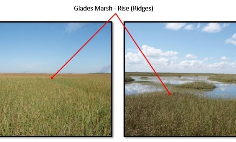
Figure 17. Glades Marsh wetlands
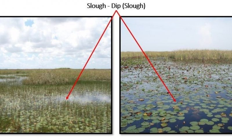
Figure 18. Slough wetlands
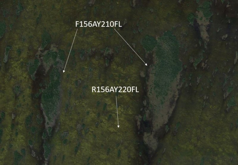
This state directly correlates with the Non-Forested Glades Marsh and Slough Wetlands Ecological Site and all information regarding this ESD should be referred to in R156AY220FL. This state becomes dominant in replacement of tree islands when they become destroyed. This can be due to hydrologic erosion of mineral soil tree islands by increased hydrologic flow due to human alteration or via destruction from intense fire during drought in the organic soil tree islands.
Characteristics and indicators. These are the sawgrass marsh and slough wetlands that are dominated by vast expanses of sawgrass with open drainageways throughout.
Dominant resource concerns
State 3
Invasive Non-Native Community
This state consists of Florida Department of Agriculture and Consumer Services (FDACS) Non-Native Category 1 Species list . More information on these species list can be found:
https://www.fdacs.gov/content/download/63140/file/Florida%E2%80%99s_Pest_Plants.pdf
or by contacting the UF / IFAS Center for Aquatic and Invasive Plants (http://plants.ifas.ufl.edu/),
the UF / IFAS Assessment of Non-native Plants in Florida's Natural Areas (https://assessment.ifas.ufl.edu/),
or the FWC Invasive Plant Management Section (http://myfwc.com/wildlifehabitats/invasive-plants/).
This community will not represent every possibility of invasive species but rather the most common in these areas.
Characteristics and indicators. Non-native species include species that exist outside of Florida's natural range and introduced to the state by people, weather, or any other means.
Resilience management. This state can be found as a part of any other state and can completely destroy the native habitat if not properly managed. Restoration to natural communities after exotic invasion include practices such as mechanical, biological, and chemical removals.
Dominant plant species
-
cattail (Typha), other herbaceous
Dominant resource concerns
-
Subsidence
-
Concentration of salts or other chemicals
-
Nutrients transported to surface water
-
Plant productivity and health
-
Plant structure and composition
State 4
Managed Resource Areas
The following communities comprise the major land uses in the United States and the land uses receiving the majority of the conservation treatment that address soil, water, air, plant, and animal resources within the USDA.
This state may not occupy a large role in this ecological site, but areas in the northern Everglades ecoregion have been extensively altered and managed for range, agriculture, and silviculture in present day uses. Any conversion to these communities have been done over a large landscape setting, primarily the Everglades Agricultural Area. Often the small tree islands will be destroyed and the area will be managed based off the (drained) highly organic soils of the surrounding glades marsh (R156AY220FL).
Characteristics and indicators. These land uses consist of areas that are not completely naturalized (i.e. native habitat) but are not completely altered by anthropogenic means.
Dominant resource concerns
-
Sheet and rill erosion
-
Wind erosion
-
Subsidence
-
Organic matter depletion
-
Concentration of salts or other chemicals
-
Seasonal high water table
-
Nutrients transported to surface water
-
Inadequate livestock shelter
Community 4.1
Rangeland
Rangelands are described as lands on which the indigenous vegetation is predominately grasses, grass-like plants, forbs, and possibly shrubs or dispersed trees. Existing plant communities can include both native and introduced plants. Primary export from Florida ranges are cattle and have been present in the state since their first introduction by Spanish explorers in 1521. This is the reference community for this state because it requires very little alterations to the landscape for grazing species.
Rangelands provide a diversity of ecosystems and also provide a diverse and significant production of economic benefits and ecosystem goods and services. Livestock production along with sustainable wildlife populations provide for the major direct economic benefits, but also tourism, recreational uses, minerals/energy production, renewable energy, and other natural resource uses can be very significant. Vital ecosystem contributions include clean water, clean air, fish/wildlife habitat, as well as intangible considerations such as historical, cultural, aesthetic and spiritual values.
Resilience management. Grazing, by both domestic livestock and wildlife, is the most common ecological management process, with fire and weather extremes also being significant ecological factors. For information regarding specific cattle grazing techniques please contact your local NRCS office.
Community 4.2
Open Transitional Managed Communities
This is an area that is managed to maintain open land before shifting to another community. These communities are often used as transitional periods from one practice to another and could lead to an abandoned / fallow field.
Community 4.3
Improved Pasture
Pasture is a land use type having vegetation cover comprised primarily of introduced or enhanced native forage species that is used for livestock grazing. Pasture vegetation can consist of grasses, legumes, other forbs, shrubs or a mixture. The majority of these forages are introduced, having originally come from areas in other states or continents. Most are now naturalized and are vital components of pasture based grazing systems.
Pasture lands provide many benefits other than forage for livestock. Wildlife use pasture as shelter and for food sources. Well managed pasture captures rainwater that is slowly infiltrated into the soil which helps recharge groundwater. Many small pasture livestock operations are near urban areas providing vistas for everyone to enjoy.
Resilience management. Pastures receive periodic renovation and cultural treatments such as tillage, fertilization, mowing, weed control, and may be irrigated. For more information regarding specific pasture management please contact your local NRCS office.
Community 4.4
Agriculture
The agriculture industry includes cultivated crops, aquaculture, and apiculture. Cultivated cropland includes areas used for the production of adapted crops for harvest. These areas comprises land in row crops or close-grown crops that are in a rotation with row or close-grown crops. Primary export from Florida consists of fruits, greenhouse and nursery products, sugar cane, and the signature export of citrus. Aquaculture includes the cultivation and maintenance of aquatic plants, aquatic reptiles, crustaceans, food/ ornamental fish, shellfish, and other miscellaneous species for harvesting. Apiculture includes the maintenance of honeybees and hives to provide beeswax, honey/ other edible bee products, crop pollination services, and sales of bees to other beekeepers. These areas have been modified resulting in land clearing practices and hydrologic management to fit the growers needs.
Resilience management. Major natural resource concerns facing agricultural lands include: (1) erosion by wind and water, (2) maintaining and enhancing soil quality, (3) water quality from nutrient and pesticides runoff and leaching, and (4) managing the quantity of water available for irrigation. For more specific information regarding cropland please contact your local NRCS office.
Community 4.5
Silviculture
Silviculture is land used in controlling the establishment, growth, composition, health, and quality of forests and woodlands to meet the diverse needs and values of landowners and society such as wildlife habitat, timber, water resources, restoration, and recreation on a sustainable basis. These are forestry practices that include thinning, harvesting, planting, pruning, prescribed burning and site preparation, for managed goals such as wildlife habitat creation or harvesting. Many managed silvicultural lands in Florida include tree plantations for growth of tropical ornamental species such as palms; and lumber, pulp, and paper species such as slash pine, longleaf pine, cypress, and eucalyptus.
This community also include management practices of agroforestry, the intentional mixing
of trees and shrubs into crop and/or animal production systems to create environmental, economic and social benefits. This is included in this community and not any other state because the primary management is for tree species. This may include practices such as riparian forest buffers, windbreaks, forest farming, silvopasture, and alley cropping.
Resilience management. Management of silvicultural lands require specific prescriptions based on the management goals for the stand, and may include thinning, harvesting, planting, pruning, prescribed burning and site preparation. For more information regarding specific management for silviculture practices please contact your local NRCS office.
Pathway 4.1A
Community 4.1 to 4.2
This pathway is driven by land clearing practices that consists of removing the existing vegetation from the habitat and altering the habitat to prepare for modified land use.
Pathway 4.2A
Community 4.2 to 4.1
This pathway is driven by the restoration of the native habitat for the use of rangeland. This includes restoration of both the hydrology and landscape in advance of replanting native species. This is a time-consuming process and often results in second-hand community structure. Once restored to a natural capacity the introduction of grazing species to the system creates a managed rangeland.
Pathway 4.2B
Community 4.2 to 4.3
This pathway is driven by preparing the land for pasteurization. This includes the planting of vegetation consisting of grasses, legumes, other forbs, shrubs or a mixture that will provide preferred forage for managed grazing species.
Pathway 4.2C
Community 4.2 to 4.4
This pathway is driven by the preparation of land for agricultural uses. This change is dependent on the type of agricultural community is being created, but often depends on the growing, maintenance, and cultivation of an agricultural product for consumers. This community may require modification to the land to fit the hydrologic requirement of the growing crop.
Pathway 4.2D
Community 4.2 to 4.5
This pathway is driven by the preparation of the land for silvicultural purposes. This change is dependent on the type of silvicultural product being cultivated, as many different practices require different growth requirement.
Pathway 4.3A
Community 4.3 to 4.2
This pathway is driven by land clearing practices that consists of removing the existing vegetation from the habitat and altering the habitat to prepare for modified land use.
Pathway 4.3B
Community 4.3 to 4.4
This pathway is driven by the preparation of land for agricultural uses. This change is dependent on the type of agricultural community is being created, but often depends on the growing, maintenance, and cultivation of an agricultural product for consumers. This community may require modification to the land to fit the hydrologic requirement of the growing crop.
Pathway 4.3C
Community 4.3 to 4.5
This pathway is driven by the preparation of the land for silvicultural purposes. This change is dependent on the type of silvicultural product being cultivated, as many different practices require different growth requirements.
Pathway 4.4A
Community 4.4 to 4.2
This pathway is driven by land clearing practices that consists of removing the existing vegetation from the habitat and altering the habitat to prepare for modified land use.
Pathway 4.4B
Community 4.4 to 4.5
This pathway is driven by the preparation of the land for silvicultural purposes. This change is dependent on the type of silvicultural product being cultivated, as many different practices require different growth requirements.
Pathway 4.5A
Community 4.5 to 4.2
This pathway is driven by land clearing practices that consists of removing the existing vegetation from the habitat and altering the habitat to prepare for modified land use.
State 5
Human Altered & Human Transported Areas
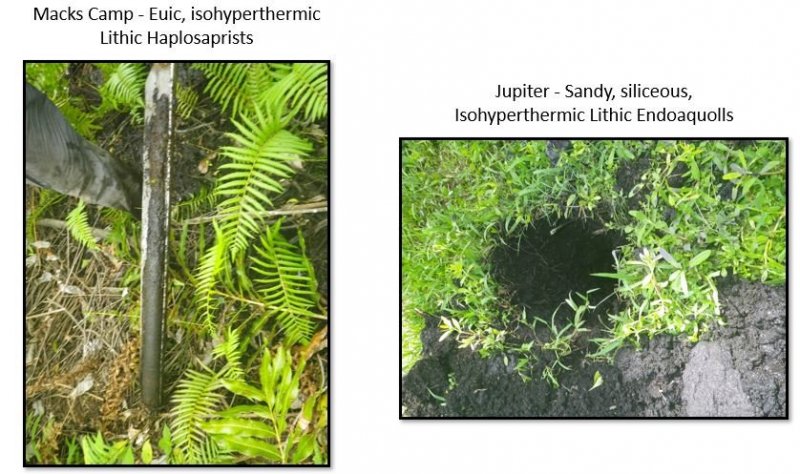
These areas include soils that were intentionally and substantially modified by humans for an intended purpose, commonly for terraced agriculture, building support, mining, transportation, and commerce. The alteration is of sufficient magnitude to result in the introduction of a new parent material (human-transported material) or a profound change in the previously existing parent material (human-altered material). They do not include soils modified through standard agricultural practices or formed soils with unintended wind and water erosion. When a soil is on or above an anthropogenic landform or microfeature, it can be definitely be associated with human activity and is assigned to a unique taxa, usually found as an "Urban land complex" within that communities natural soil properties (e.g., Macks Camp muck, ponded-Urban land complex, 0-2% slopes, occasionally flooded).
Characteristics and indicators. Evidence of these areas include soils with manufactured items (e.g. artifacts) present in the profile, human altered-materials (e.g., deeply excavated or deeply plowed soil) or human-transported material (e.g., fill), and position on or above anthropogenic landforms (e.g., flood-control levees) and microfeatures (e.g., drainage ditches). Detailed criteria regarding the identification of anthropogenic (artificial) landforms, human-altered materials, and human-transported material are in the "Keys to Soil Taxonomy" (Soil Survey Staff, 2014).
Dominant resource concerns
-
Compaction
-
Ponding and flooding
-
Seasonal high water table
-
Emissions of greenhouse gases (GHGs)
-
Objectionable odors
-
Plant productivity and health
-
Plant structure and composition
Community 5.1
Reclaimed Areas
Reclaimed areas are areas that have been modified through anthropogenic means that are restored to a natural or second-hand natural community. Areas that can be reclaimed are any intensely urbanized areas, and may be required to be reclaimed after urban use (e.g., active mines must be reclaimed). Examples of reclaimed lands may be shut down phosphate mining operations, superfund sites, or brownfields. These practices include the identification, removal, and stockpiling soil materials before altering the land, and revegetation and replacement of soil materials after altering the land. This also applies to nearby urban areas that have been adversely affected by the anthropogenic activities.
Community 5.2
Urban
This urban community consists of development for human use. Urban areas include a variety of land uses, e.g., inner city or urban core, industrial and residential areas, cemeteries, parks, and other open spaces; the overall function which may benefit the quality of human life. These often form an urban soil mosaic, where the natural landscape has been fragmented into parcels with distinctive disturbance and management regimes and, as a result, distinctive characteristic soil properties.
Within this community there are three different levels of urbanization, based off population dynamics, residential density, and intensity of development. These are labeled as low-intensity, medium-intensity, and high-intensity urban areas, which can eventually be split apart into its own separate state. Low-intensity urban areas may consist of single dwelling homes with little impact on the surrounding community which still somewhat represents the natural community (e.g., represents natural landscape, hydrology, and vegetation) , other examples of this are urban parks, cemeteries, or campgrounds with little urban development. Medium-intensity urban areas consist of larger urban dwellings with some natural features, but have been modified to meet urban needs (e.g., towns). High-intensity urban areas are areas of heavily modified areas with complete alterations of the natural landscape, hydrology, and vegetation to support a very large population, which once constructed is permanently altered (e.g., metropolis areas).
Community 5.3
Non-Reclaimed Areas
Non-reclaimed areas are areas that have been modified through anthropogenic means that are unable to be restored to a natural or second-hand natural community. Areas that cannot be reclaimed are areas under active mining status or mined areas before the Phosphate Land Reclamation Act in 1975, which leaves shut down operations alone. These areas also include fallow mines that have been flooded and are now permanent bodies of water.
Community 5.4
Landfills
This is an anthropogenic site for the disposal of waste material. It includes manufactured layers (artificial, root limiting layer below the soil surface) that are representative of human altered and human transported sites. These layers are often alternative between natural fill material and geotextile liners, asphalt, concrete, rubber or plastic that are built up and can rise above the surrounding landscape by 30 meters or more often impeding water, gas, or roots from moving through the profile.
Pathway 5.1A
Community 5.1 to 5.2
This shift in communities is driven by clearing and developing the land for the desired community.
Pathway 5.1B
Community 5.1 to 5.4
This transition is driven by the deposition of manufactured layers along with anthropogenic waste which is consistently built upon.
Pathway 5.2A
Community 5.2 to 5.1
This transition is driven by the revegetation, reestablished hydrology, and replacement of displaced soil materials after altering the land.
Pathway 5.2B
Community 5.2 to 5.3
This transition is driven from heavy industrial or urban development which causes the land to become non-reclaimable. This transition is rare due to the many environmental laws and regulations that must be followed when developing.
Pathway 5.2C
Community 5.2 to 5.4
This transition is driven by the deposition of manufactured layers along with anthropogenic waste which is consistently built upon.
Pathway 5.3A
Community 5.3 to 5.1
This transition is driven by the revegetation, reestablished hydrology, and replacement of displaced soil materials after altering the land.
Transition T1A
State 1 to 2
Forested Wetlands (Tree Islands)
Non-Forested Glades Marsh and Slough Wetlands
This transition is driven by a disturbance which may be natural or anthropogenic, resulting in destruction of the island. Mineral soil tree islands may be lost from anthropogenic activities such as channelization and altering the natural hydroperiod of the landscape, which may permanently flood or erode the mineral soils of the island. Organic islands may be destroyed during periods of drought when fire enters the system and burns the organic material.
Transition T1B
State 1 to 3
The invasion of non-native or exotic species can be driven by a multitude of different environmental factors such as changes in natural hydroperiods or in fire regimes. Typically once a change in one of the two factors mentioned above occurs, non-native or exotic invasive species become established and begin to compete with native species for habitat and nutrients.
Constraints to recovery. Recovery from non-native or exotic invasive species may be difficult due to many adaptations which allow them to outcompete and survive in altered conditions. Localized knowledge for each species must be known for best removal of it without harming the native environment, and often different treatments must be applied over one given area.
Context dependence. Growth of non-native and exotic invasive species can be rapid following a change in a natural stressor such as fire frequency or natural hydroperiods which might have once kept the invasive species at bay.
Transition T1C
State 1 to 4
Modify the land for the desired land use. This may include the establishment of grazing species or the modification of land for the cultivation of crops of other desired products.
Transition T1D
State 1 to 5
This transition is driven by the alteration and/ or transportation of materials via anthropogenic means.
Transition T2A
State 2 to 1
Non-Forested Glades Marsh and Slough Wetlands
Forested Wetlands (Tree Islands)
This transition is only for the formation of organic soil tree islands. Once a mineral soil tree island is destroyed that ecological community is lost, and may only be replaced with organic soil tree islands.
The formation of organic tree islands (specifically ballgalls or willow heads), results from the accumulation of organic matter. Floating mats of organic matter may travel down the drainageways (sloughs) and become stuck, building organic material as sawgrass decomposes over long periods of time. If woody seeds are introduced into the system, this may grow and allow for the development of baygall or willow head.
Context dependence. Note this is a very time depending process and may take hundreds to thousands of year to accumulate organic matter and is dependent on local fire frequency.
Restoration pathway R3A
State 3 to 1
Mechanical, biological, and chemical removal strategies include removing the non-native and exotic invasive species through various mechanisms. Localized knowledge for individual non-native or exotic invasive species is needed for specific management. Sometimes introduction of fire regimes may prevent or stop the growth of non-native or exotic invasive species, but many species are fire tolerant. Mechanical removal might include cutting and removal of invasive species. Chemical removal might include spot spraying or basal bark injection treatments.
Context dependence. Mechanical, biological, and chemical removal of non-native and exotic invasive species is a time dependent process, with both removal types taking long times to be considered effective.
Transition T3A
State 3 to 5
This transition is driven by the alteration and/ or transportation of materials via anthropogenic means.
Restoration pathway R4A
State 4 to 1
These practices include the restoration of both the natural hydroperiods and landscape in advance of revegetating the area (if needed).
Transition T4A
State 4 to 5
This transition is driven by the alteration and/ or transportation of materials via anthropogenic means.
Restoration pathway R5A
State 5 to 4
This transition is driven by the restoration of a reclaimed land towards a naturally managed resource such as agriculture, rangeland, silviculture, or improved pasture.