Natural Resources
Conservation Service
Ecological site R030XB231CA
Shallow To Moderately Deep Petrocalcic Fan Remnants (Provisional)
Accessed: 05/12/2025
General information
Provisional. A provisional ecological site description has undergone quality control and quality assurance review. It contains a working state and transition model and enough information to identify the ecological site.
MLRA notes
Major Land Resource Area (MLRA): 030X–Mojave Basin and Range
Major Land Resource Area (MLRA) 30, Mojave Desert, is found in southern California, southern Nevada, the extreme southwest corner of Utah and northwestern Arizona within the Basin and Range Province of the Intermontane Plateaus. The climate of the area is hot and dry. Hyperthermic and thermic soil termperature regimes are common with exceptions at higher elevations (generally above 5000 feet) where mesic, cryic and frigid soil temperature regimes may occur. Typic aridic soil moisture regimes are common and widespread throughout the MLRA. Elevations range from below sea level to over 12,000 feet in the higher mountain areas found within the MLRA. Due to the extreme elevational range found within this MLRA, Land Resource Units (LRUs) were designated to group the MLRA into similar land units.
LRU Description
The XB LRU is found across the eastern half of California, much of the mid-elevations of Nevada, the southernmost portions of western Utah, and the mid-elevations of northwestern Arizona. Elevations range from 1800-5000 feet and precipitation ranges from 4-9 inches/year, but is generally between 5-6 inches. This LRU is characterized primarily by summer precipitation, which ranges from 18-35% but averages 25%. Summer precipitation falls between July and September in the form of rain, and winter precipitation falls starting in November and ends between February and March, also mostly in the form of rain; however it does receive between 0 and 3 inches of snow, with an average of 1 inch. The soil temperature regime is thermic and the soil moisture regime is typic-aridic. Vegetation includes creosote bush (Larrea tridentata), burrobush (Ambrosia dumosa), Mojave yucca (Yucca schidigera) Joshua tree (Yucca brevifolia), chollas, cactus, big galleta grass (Pleuraphis rigida) and several other warm season grasses. At the upper portions of the LRU, plant production and diversity are greater and blackbrush (Coleogyne ramosissima) is a common dominant shrub.
Ecological site concept
This site occurs on gently sloping alluvial fan remnants at elevations of approximately 3300 to 3900 feet. Soils have loamy to coarse loamy textures, and are shallow to moderately deep to a petrocalcic horizon. The soil moisture regime is typic aridic and the soil temperature regime is thermic. Creosote bush (Larrea tridentata) and winterfat (Krascheninnikovia lanata) are the dominant shrubs of the reference plant community, and big galleta (Pleuraphis rigida) is an important grass. Burrobush (Ambrosia dumosa) is an important secondary shrub that becomes more abundant as perennial grasses are lost with grazing. This species is more competitive on the shallow soils of this site than on adjacent deeper soils. Production reference value (RV) is 492 pounds per acre, and ranges from 332 to 691 pounds per acre depending on annual precipitation. Winterfat is more abundant on adjacent higher elevations, but does well on these well-drained moderately alkaline soils. Creosote bush is a dominant on most surrounding landforms at this elevation. Big galleta is less abundant on this site than on adjacent deeper soils with higher water holding capacity, but becomes dominant with disturbance that removes shrub competition.
Associated sites
| R030XB107NV |
COARSE GRAVELLY LOAM 5-7 P.Z. Occurs on adjacent fan remnants with steeper slopes. Blackbrush (Coleogyne ramosissima) and big galleta (Pleuraphis rigida) are dominant in undisturbed states. |
|---|---|
| R030XY222CA |
Typic Aridic Ephemeral Drainageway Order 3 4-7" p.z. This site occurs on adjacent large ephemeral drainageways. Desert willow (Chilopsis linearis) and catclaw acacia (Acacia greggii) are important species. |
| R030XY227CA |
Sandy Thermic Narrow Channels This site occurs on adjacent small ephemeral drainageways. Mojave desert plum (Prunus eremophila) and catclaw acacia (Acacia greggii) are characteristic species. |
Similar sites
| R030XB043NV |
CLAYPAN 5-7 P.Z. This site occurs on soils with an argillic horizon and a very deep petrocalcic horizon. Winterfat is trace if present, and big galleta is dominant. |
|---|
Table 1. Dominant plant species
| Tree |
Not specified |
|---|---|
| Shrub |
(1) Larrea tridentata |
| Herbaceous |
(1) Pleuraphis rigida |
Physiographic features
This ecological site occurs on fan remnants with slopes of 1 to 4 percent. Elevations range from 3380 to 3870 feet. Runoff class is negligible to very low.
Table 2. Representative physiographic features
| Landforms |
(1)
Fan remnant
|
|---|---|
| Flooding frequency | None |
| Elevation | 3,380 – 3,870 ft |
| Slope | 1 – 4% |
Climatic features
Influencing water features
Soil features
The soils associated with this ecological site are very shallow to moderately deep over a petrcocalcic horizon, and formed in alluvium derived from igneous, sedimentary, and metamorphic rock. They are well drained with slow to moderately rapid permeability. The soil moisture regime is typic aridic and the soil temperature regime is thermic. Surface rock fragments smaller than 3 inches in diameter range from 20 to 22 percent, and larger fragments generally are not present. The surface texture is sandy loam. Subsurface textures are fine sandy loam, cemented loamy sand, and cemented sandy loam, and sandy loam. Subsurface rock fragments smaller than 3 inches in diameter range from 5 to 13 percent by volume, and larger fragments are typically not present (for a depth of 0 to 39 inches). The dominant soils correlated to this site include Baldspot (loamy, mixed, superactive, thermic, shallow calcic Petrocalcids) and Bluesnake (coarse-loamy, mixed, superactive, thermic, calcic Petrocalcids). A minor component of Yorktain (fine-loamy, mixed, superactive, thermic, argic Petrocalcids) is also correlated to this site. Baldspot soils are very shallow to shallow over a thick cemented petrocalcic horizon, and are derived from igneous and sedimentary rock. Bluesnake soils are moderately deep and are derived from metamorphic and sedimentary rock, and Yorktain soils are moderately deep and derived from limestone and dolomite.
This ecological site has been correlated with the following mapunits and soil components in the Mojave National Preserve soil survey area (CA795):
Mapunit symbol ; Mapunit name ; Component ; Phase ; Percent
208 ; Bluesnake loamy sand, 1 to 4 percent slopes ; Bluesnake ; ; 90
405 ; Baldspot sandy loam, 1 to 4 percent slopes ; Baldspot ; ; 85
204 ; Noshade fine sandy loam, 1 to 4 percent slopes ; Baldspot ; ; 6
402 ; Yorktain complex, 1 to 4 percent slopes ; Yorktain ; cool ; 5
Table 3. Representative soil features
| Surface texture |
(1) Sandy loam |
|---|---|
| Family particle size |
(1) Loamy |
| Drainage class | Well drained |
| Permeability class | Slow to moderately rapid |
| Soil depth | 8 – 39 in |
| Surface fragment cover <=3" | 20 – 22% |
| Surface fragment cover >3" | Not specified |
| Available water capacity (0-40in) |
0.8 – 3.8 in |
| Calcium carbonate equivalent (0-40in) |
1 – 14% |
| Electrical conductivity (0-40in) |
2 mmhos/cm |
| Sodium adsorption ratio (0-40in) |
4 |
| Soil reaction (1:1 water) (0-40in) |
6.1 – 8.6 |
| Subsurface fragment volume <=3" (Depth not specified) |
5 – 13% |
| Subsurface fragment volume >3" (Depth not specified) |
Not specified |
Ecological dynamics
Abiotic factors
This site occurs on gently sloping alluvial fan remnants at elevations of approximately 3300 to 3900 feet. Soils have loamy to coarse loamy textures, and are shallow to moderately deep to a petrocalcic horizon. The soil moisture regime is typic aridic and the soil temperature regime is thermic. Creosote bush and winterfat are the dominant shrubs of the reference plant community, and big galleta is an important grass. Burrobush is an important secondary shrub that becomes more abundant as perennial grasses are lost with grazing. This species is more competitive on the shallow soils of this site than on adjacent deeper soils. Production reference value (RV) is 492 pounds per acre, and ranges from 332 to 691 pounds per acre depending on annual precipitation. Winterfat is more abundant on adjacent higher elevations, but does well on these well-drained moderately alkaline soils. Creosote bush is a dominant on most surrounding landforms at this elevation. Big galleta is less abundant on this site than on adjacent deeper soils with higher water holding capacity, but becomes dominant with disturbance that removes shrub competition.
Disturbance dynamics
The disturbances impacting this plant community are fire, invasion by non-native annual species, livestock grazing, and land-clearing for dryland farming.
Prior to European settlement, fire in this ecological site was likely relatively rare due to low abundance of fine fuels between shrubs, and patchy perennial grasses (e.g. Brown and Minnich 1986, Brooks and Matchett 2006, Brooks et al. 2007). The low moisture holding capacity in these shallow to moderately deep soils do not support an abundant annual community, but one or multiple years of heavy winter precipitation such as occurs during El Nino events (Hereford et al. 2006), or heavy summer precipitation could lead to a relatively heavy standing crop of native annuals in intershrub spaces, providing a continuous fine fuel layer that could carry a fire (Brown and Minnich 1986, Minnich 2003). Years of heavy summer or early fall precipitation that lead to high production in big galleta, also increasing fire likelihood (Minnich 2003). The dominant shrubs, creosote bush and winterfat, are killed by moderate to high severity fire (Carey 1995, Brooks et al. 2007), and typically take many years to recolonize after a stand-clearing fire (e.g Brown and Minnich 1986, Brooks et al. 2007, Engel and Abella 2011, Steers and Allen 2011). Following fire, big galleta gains dominance in this site, and annuals greatly increase in abundance with release from competition with shrubs, and this increase in fine fuels increases the likelihood of repeat burning.
Naturalization of non-native annual species such as red brome (Bromus rubens), common Mediterranean grass (Schismus barbatus), cheatgrass (Bromus tectorum), and redstem storks bill (Erodium cicutarium) with European exploration and settlement from the 1860s through the 1900s (e.g. Brooks and Chambers 2011) caused a transition from the reference state, which contained only native species, to a state that included non-native species (State 2). Invasion by non-native annual grasses is thought to have increased flammability of invaded Mojave Desert shrublands by providing higher levels of fine fuels (e.g. Brown and Minnich 1986, Brooks et al. 2004, Brooks and Chambers 2011). After fire, these communities appear to be more susceptible to invasion by exotic grasses, which may lead to a grass-fire cycle (D'Antonio and Vitousek 1992). In this ecological site, abundance of native annuals and big galleta was found to be more significant after disturbance than invasion by non-native annuals, although non-native annuals certainly have the potential to become a problem. Winterfat re-establishment is greatly suppressed by the presence of abundant annual grasses and can also be suppressed by native perennial grasses, which typically recover well after fire (Woodmansee and Potter 1971, Hild et al. 2007); thus recurrent fire can prevent winterfat recovery.
Ranching was established in the eastern Mojave desert in approximately 1875 (Nystrom 2003). Grazing occurred unregulated in the area until the passage of the Taylor Grazing Act in 1934, which divided public land into allotments that were regulated by the Bureau of Land Management (BLM), and among other things, called for fenced ranges and multiple developed water sources (http://www.blm.gov/wy/st/en/field_offices/Casper/range/taylor.1.html). The Federal Land Policy and Management Policy Act of 1976 (FLPMA) brought further regulations, including 10-year grazing permits. In 1994 the California Desert Protection Act created the Mojave National Preserve, and the National Park Service took over management of grazing allotments in much of the eastern Mojave Desert where this site occurs. All of the area occupied by this ecological site within the Mojave National Preserve was retired from grazing in 2000 (Lanfair Valley and Kessler Spring Allotments) (Kim 2004).
Heavy cattle grazing in the arid west has been shown to have numerous negative effects on vegetative communities, including decreases in cryptogram crust cover, seedling survival, total biomass, perennial grass and shrub cover, and litter cover (Jones 2000). In addition, soils and hydrology may be impacted, with reduced infiltration, increased runoff and erosion (e.g. Rauzi and Hanson 1966, Rauzi and Smith 1973, Jones 2000), and soil compaction (Rauzi and Hanson 1966, Abdel-Magid et al. 1987). Grazing in winterfat dominated communities has been demonstrated to increase soil compaction, lower soil aggregate stability, increase bare ground cover and decrease winterfat, biological crust, and litter cover (Rasmussen and Brotherson 1986, Matney 2010). Grazing may cause shifts in species composition from more palatable to less palatable species, and to species more tolerant of mechanical disturbance, or with a shorter life-cycle (Rasmussen and Brotherson 1986). Ten years of monitoring (1970 to 1980) of a grazing system where sites were rested every other year in the Arizona strip of the Mojave Desert, which has similar climatic and environmental characteristics as this site, found an upward trend in winterfat and burrobush cover, and typically (but not always) downward trends on big galleta cover (Hughes 1982). Higher utilization, e.g. above 50 percent, caused loss of native perennial grasses (Hughes 1982), potentially causing a permanent shift to a degraded state. This state has not been observed in this ecological site, and is not included in the state-and-transition model; however, land managers should be aware that the potential for a permanent transition with sustained heavy grazing exists.
Large portions of this ecological site were cleared for dryland farming and homesteading in the early 1900s to 1920s (Carpenter et al. 1986, Sharp and Moore 2004). Existing vegetation was chained and soils were plowed, but most were abandoned by 1930 (Carpenter et al. 1986). Many of these cleared areas were subsequently grazed until 2000. Recovery of these cleared areas resembles recovery after fire; big galleta is strongly dominant, the dominant shrubs are greatly reduced, overall diversity is higher, and annual species are more abundant.
All tabular data listed for a specific community phase within this ecological site description represent a summary of one or more field data collection plots taken in modal communities within the community phase. Although such data are valuable in understanding the phase (kinds and amounts of ground and surface materials, canopy characteristics, community phase overstory and understory species, production and composition, and growth), they do not represent the absolute range of characteristics or an exhaustive listing of all species that may occur in that phase over the geographic range of the ecological site.
State and transition model
Figure 1. R030XB231CA
More interactive model formats are also available.
View Interactive Models
More interactive model formats are also available.
View Interactive Models
Click on state and transition labels to scroll to the respective text
Ecosystem states
State 1 submodel, plant communities
State 2 submodel, plant communities
| 2.1a | - | moderate to severe fire or land-clearing. |
|---|---|---|
| 2.1b | - | grazing |
| 2.2a | - | time and a lack of further disturbance |
| 2.3a | - | time and a lack of further disturbance |
State 1
Reference
This state represents the natural range of variability for this ecological site, pre-European settlement. This state no longer exists due to the naturalization of non-native species, and data for this state does not exist. This state had infrequent fire, only native species, and no livestock grazing. Fluctuations in annual productivity would have occurred with climatic variability.
Community 1.1
Reference Community
The reference plant community was dominated by creosote bush and winterfat, with big galleta an important species. Secondary perennial grasses including bush muhly (Muhlenbergia porteri) and Indian ricegrass (Achnatherum hymenoides) were also present, and perennial grass cover was likely higher prior to the introduction of grazing (Brooks et al. 2007).
State 2
Grazed, Non-native Species Present
This is the representative state for this ecological site. It is similar in composition to the reference state, but non-native species are present, perennial grasses may be less abundant, and livestock grazing and high severity, large fires introduce new ecological dynamics.
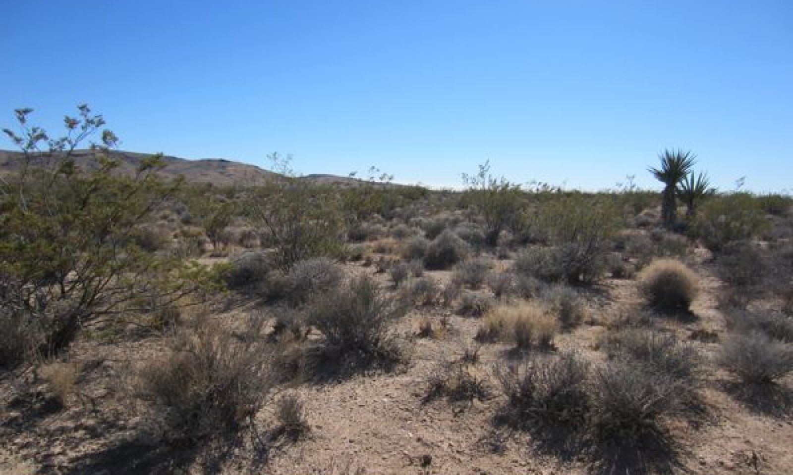
Community 2.1
Representative Community
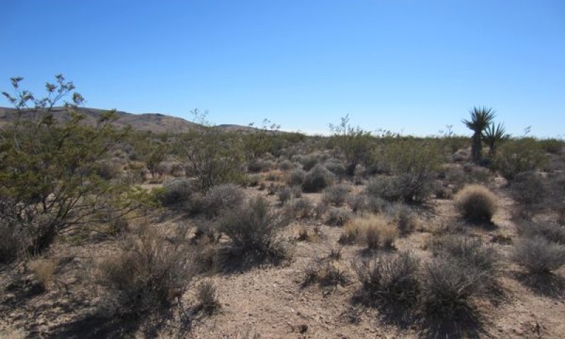
Figure 2. Community Phase 2.1
This plant community is dominated by creosote bush and winterfat, which provides approximately 50 percent of annual production. Big galleta is the dominant perennial grass, at 10 to 13 percent annual production, and bush muhly and Indian ricegrass are important secondary perennial grasses. Nevada ephedra (Ephedra nevadensis) and burrobush) are important secondary shrubs. Minor shrubs include littleleaf ratany (Krameria erecta), waterjacket (Lycium andersonii), Mojave yucca (Yucca schidigera), threadleaf snakeweed (Gutierrezia microcephala), and rayless goldenhead (Acamptopappus spherocephalus). Native perennial forbs including desert globemallow (Sphaeralcea ambigua), desert trumpet (Eriogonum inflatum), whitestem paperflower (Psilostrophe cooperi), and Mojave woodyaster (Xylorhiza tortifolia) contribute a small proportion of annual production. Native annual forbs recorded in the representative phase include the summer annual manybristle chinchweed (Pectis papposa). The native annual grass sixweeks grama (Bouteloua barbata) may be abundant with high summer precipitation. The non-native redstem storks bill is present but not abundant. Ungrazed representative community data are not available. The community phase data presented below has been free of grazing for approximately 12 years, and represent the best ecological condition that could be located. Winterfat and perennial grass production and cover were probably higher prior to grazing.
Figure 3. Annual production by plant type (representative values) or group (midpoint values)
Table 4. Annual production by plant type
| Plant type | Low (lb/acre) |
Representative value (lb/acre) |
High (lb/acre) |
|---|---|---|---|
| Shrub/Vine | 250 | 370 | 490 |
| Grass/Grasslike | 57 | 85 | 113 |
| Forb | 25 | 37 | 50 |
| Tree | 0 | 0 | 38 |
| Total | 332 | 492 | 691 |
Table 5. Ground cover
| Tree foliar cover | 0-1% |
|---|---|
| Shrub/vine/liana foliar cover | 25-35% |
| Grass/grasslike foliar cover | 10-12% |
| Forb foliar cover | 1-3% |
| Non-vascular plants | 0% |
| Biological crusts | 0% |
| Litter | 3-8% |
| Surface fragments >0.25" and <=3" | 20-35% |
| Surface fragments >3" | 0% |
| Bedrock | 0% |
| Water | 0% |
| Bare ground | 15-35% |
Table 6. Canopy structure (% cover)
| Height Above Ground (ft) | Tree | Shrub/Vine | Grass/ Grasslike |
Forb |
|---|---|---|---|---|
| <0.5 | – | 0-1% | 0-2% | 0-3% |
| >0.5 <= 1 | 0-1% | 0-5% | 0-2% | 0-3% |
| >1 <= 2 | 0-1% | 20-25% | 8-15% | 0-5% |
| >2 <= 4.5 | 0-1% | 10-15% | 1-3% | – |
| >4.5 <= 13 | 0-1% | 0-5% | – | – |
| >13 <= 40 | 0-1% | – | – | – |
| >40 <= 80 | – | – | – | – |
| >80 <= 120 | – | – | – | – |
| >120 | – | – | – | – |
Community 2.2
Fire/Clearing Recovery
Figure 4. Community Phase 2.2
Initially annual species and resprouting or re-colonizing herbaceous species dominate. Native perennial forbs that often become dominant after fire include desert globemallow, desert trumpet (Eriogonum inflatum), brownplume wirelettuce (Stephanomeria pauciflora), and desert marigold (Baileya multiradiata). If burned when big galleta is green (which would typically be the case during the summer monsoon season), big galleta will quickly resprout and become abundant (Matthews 2000, Minnich 2003), though if big galleta is dormant when burned, it may be killed by a hot fire (Matthews 2000). The community phase data presented in the tables and described in the narrative below represent an example of community composition approximately 100 years after land clearing. Depending on the stage of recovery, and climatic conditions after recovery, different community compositions are likely. This community phase is characterized by dominance by big galleta, with 23 to 28 percent annual production, and dominance by grasses with over 50 percent of annual production. Shrubs contribute approximately one third of production, versus 75 percent in the reference community. Creosote bush and winterfat are the most abundant shrubs, but together contribute less than 25% of annual production. The disturbance adapted Cooper’s goldenbush (Ericameria cooperi) is an abundant shrub in this phase. Annual species are much more abundant, contributing 30 percent of annual production versus four percent in the representative phase. The non-native annual grasses red brome and common Mediterranean grass are both present, and redstem storks bill is abundant. Increased cover and biomass of big galleta and annuals makes this community more susceptible to repeat burning, which would perpetuate this phase.
Figure 5. Annual production by plant type (representative values) or group (midpoint values)
Table 7. Annual production by plant type
| Plant type | Low (lb/acre) |
Representative value (lb/acre) |
High (lb/acre) |
|---|---|---|---|
| Grass/Grasslike | 290 | 570 | 665 |
| Shrub/Vine | 300 | 360 | 420 |
| Forb | 113 | 135 | 157 |
| Tree | 0 | 0 | 10 |
| Total | 703 | 1065 | 1252 |
Table 8. Ground cover
| Tree foliar cover | 0-1% |
|---|---|
| Shrub/vine/liana foliar cover | 25-35% |
| Grass/grasslike foliar cover | 35-45% |
| Forb foliar cover | 10-15% |
| Non-vascular plants | 0% |
| Biological crusts | 5-10% |
| Litter | 1-3% |
| Surface fragments >0.25" and <=3" | 5-10% |
| Surface fragments >3" | 0% |
| Bedrock | 0% |
| Water | 0% |
| Bare ground | 2-10% |
Table 9. Canopy structure (% cover)
| Height Above Ground (ft) | Tree | Shrub/Vine | Grass/ Grasslike |
Forb |
|---|---|---|---|---|
| <0.5 | – | – | 0-25% | 0-5% |
| >0.5 <= 1 | – | 0-5% | 0-5% | 0-2% |
| >1 <= 2 | 0-1% | 15-25% | 151-20% | 0-5% |
| >2 <= 4.5 | 0-1% | 0-1% | 2-4% | 0-1% |
| >4.5 <= 13 | 0-1% | – | – | – |
| >13 <= 40 | – | – | – | – |
| >40 <= 80 | – | – | – | – |
| >80 <= 120 | – | – | – | – |
| >120 | – | – | – | – |
Community 2.3
Grazed (Provisional)
This community phase may develop with grazing, especially at higher utilization levels (Hughes 1982). Shrubs become more dominant as perennial grasses decline. As grasses are reduced, secondary shrubs such as burrobush and threadleaf snakeweed may increase. With continued declines in grasses, browse species such as winterfat and burobush may begin to decline, while unpalatable species like creosote bush and threadleaf snakeweed increase. Bare ground increases and soils are at risk of erosion in phase. This community phase is at risk of transitioning to a degraded state where perennial grasses are lost with ongoing heavy grazing.
Pathway 2.1a
Community 2.1 to 2.2
Occurs with moderate to severe fire or land-clearing.
Pathway 2.1b
Community 2.1 to 2.3
Occurs with grazing.
Pathway 2.2a
Community 2.2 to 2.1
Occurs with time and a lack of further disturbance such as burning or grazing. The time necessary for recovery is unknown.
Pathway 2.3a
Community 2.3 to 2.1
Occurs with time, with no additional disturbance including grazing and severe drought. The time necessary for recovery is unknown.
Transition T1
State 1 to 2
This transition occurred with naturalization of non-native annual species such as red brome (Bromus rubens), cheatgrass (Bromus tectorum), and redstem storks bill (Erodium cicutarium), and the introduction of livestock grazing with European exploration and settlement from the 1860s through the 1900s (e.g. Brooks and Chambers 2011). The ubiquitous presence of non-native annuals means that removing them entirely and returning to the reference state is not possible.
Additional community tables
Table 10. Community 2.1 plant community composition
| Group | Common name | Symbol | Scientific name | Annual production (lb/acre) | Foliar cover (%) | |
|---|---|---|---|---|---|---|
|
Shrub/Vine
|
||||||
| 1 | Shrubs | 250–490 | ||||
| creosote bush | LATR2 | Larrea tridentata | 98–194 | 10–15 | ||
| winterfat | KRLA2 | Krascheninnikovia lanata | 78–155 | 4–6 | ||
| Nevada jointfir | EPNE | Ephedra nevadensis | 52–102 | 1–3 | ||
| burrobush | AMDU2 | Ambrosia dumosa | 14–28 | 4–6 | ||
| water jacket | LYAN | Lycium andersonii | 0–10 | 0–5 | ||
| littleleaf ratany | KRER | Krameria erecta | 5–9 | 1–2 | ||
| Mojave yucca | YUSC2 | Yucca schidigera | 0–4 | 0–1 | ||
| rayless goldenhead | ACSP | Acamptopappus sphaerocephalus | 0–4 | 0–1 | ||
| threadleaf snakeweed | GUMI | Gutierrezia microcephala | 0–4 | 0–1 | ||
|
Grass/Grasslike
|
||||||
| 2 | Perennial Grasses | 43–85 | ||||
| big galleta | PLRI3 | Pleuraphis rigida | 33–65 | 6–10 | ||
| bush muhly | MUPO2 | Muhlenbergia porteri | 11–21 | 1–3 | ||
| 3 | Native Annual Grasses | 0–27 | ||||
| sixweeks grama | BOBA2 | Bouteloua barbata | 0–27 | 0–4 | ||
|
Forb
|
||||||
| 4 | Perennial Forbs | 25–50 | ||||
| desert trumpet | ERIN4 | Eriogonum inflatum | 13–26 | 1–2 | ||
| Mojave woodyaster | XYTO2 | Xylorhiza tortifolia | 7–14 | 1–2 | ||
| whitestem paperflower | PSCO2 | Psilostrophe cooperi | 3–5 | 1–2 | ||
| whitemargin sandmat | CHAL11 | Chamaesyce albomarginata | 0–2 | 0–1 | ||
| 5 | Native Annual Forbs | 0–2 | ||||
| manybristle chinchweed | PEPA2 | Pectis papposa | 0–2 | 0–1 | ||
| 6 | Non-native Annual Forbs | 0–2 | ||||
| redstem stork's bill | ERCI6 | Erodium cicutarium | 0–2 | 0–1 | ||
|
Tree
|
||||||
| 7 | Trees | 0–38 | ||||
| Jaeger's Joshua tree | YUBRJ | Yucca brevifolia var. jaegeriana | 0–38 | 0–1 | ||
Table 11. Community 2.2 plant community composition
| Group | Common name | Symbol | Scientific name | Annual production (lb/acre) | Foliar cover (%) | |
|---|---|---|---|---|---|---|
|
Shrub/Vine
|
||||||
| 1 | Shrubs | 300–420 | ||||
| creosote bush | LATR2 | Larrea tridentata | 110–164 | 2–4 | ||
| winterfat | KRLA2 | Krascheninnikovia lanata | 42–63 | 4–6 | ||
| Cooper's goldenbush | ERCO23 | Ericameria cooperi | 38–57 | 4–6 | ||
| Nevada jointfir | EPNE | Ephedra nevadensis | 23–34 | 4–6 | ||
| water jacket | LYAN | Lycium andersonii | 10–14 | 1–3 | ||
| burrobrush | HYSA | Hymenoclea salsola | 7–10 | 5–7 | ||
| spiny hopsage | GRSP | Grayia spinosa | 7–10 | 1–3 | ||
| rayless goldenhead | ACSP | Acamptopappus sphaerocephalus | 3–4 | 3–5 | ||
| threadleaf snakeweed | GUMI | Gutierrezia microcephala | 3–4 | 1–3 | ||
|
Grass/Grasslike
|
||||||
| 2 | Perennial Grasses | 290–403 | ||||
| big galleta | PLRI3 | Pleuraphis rigida | 197–294 | 10–15 | ||
| low woollygrass | DAPU7 | Dasyochloa pulchella | 23–35 | 1–3 | ||
| bush muhly | MUPO2 | Muhlenbergia porteri | 12–18 | 3–5 | ||
| mesa dropseed | SPFL2 | Sporobolus flexuosus | 0–5 | 0–1 | ||
| Indian ricegrass | ACHY | Achnatherum hymenoides | 0–5 | 0–1 | ||
| 3 | Native Annual Grasses | 0–234 | ||||
| sixweeks grama | BOBA2 | Bouteloua barbata | 0–234 | 0–25 | ||
| 4 | Non-native Annual Grasses | 0–2 | ||||
| red brome | BRRU2 | Bromus rubens | 0–1 | 0–1 | ||
| common Mediterranean grass | SCBA | Schismus barbatus | 0–1 | 0–1 | ||
|
Forb
|
||||||
| 5 | Perennial Forbs | 29–40 | ||||
| whitestem paperflower | PSCO2 | Psilostrophe cooperi | 9–14 | 3–5 | ||
| desert globemallow | SPAM2 | Sphaeralcea ambigua | 3–5 | 1–2 | ||
| 6 | Native Annual Forbs | 0–43 | ||||
| Sonoran sandmat | CHMI7 | Chamaesyce micromera | 0–36 | 0–6 | ||
| largebract spiderling | BOWR | Boerhavia wrightii | 0–3 | 0–1 | ||
| bristly fiddleneck | AMTE3 | Amsinckia tessellata | 0–1 | 0–1 | ||
| little deserttrumpet | ERTR8 | Eriogonum trichopes | 0–1 | 0–1 | ||
| evening primrose | OENOT | Oenothera | 0–1 | 0–1 | ||
| manybristle chinchweed | PEPA2 | Pectis papposa | 0–1 | 0–1 | ||
| 7 | Non-native Annual Forbs | 0–62 | ||||
| redstem stork's bill | ERCI6 | Erodium cicutarium | 0–62 | 0–3 | ||
|
Tree
|
||||||
| 8 | Trees | 0–10 | ||||
| Jaeger's Joshua tree | YUBRJ | Yucca brevifolia var. jaegeriana | 0–10 | 0–1 | ||
Interpretations
Animal community
Winterfat provides highly valuable winter forage for native browsers and domestic wildlife (e.g. Carey 1995, Matney 2010). Big galleta is a valuable forage plant for livestock, and is especially palatable after summer rains (Williams 2003). Declines in big galleta were observed with grazing in burned Utah blackbrush communities (Hughes 2002), and in intact creosote bush communities in Arizona (Hughes 1982). Declines in both communities occurred regardless of grazing management system, and are likely due to heavy utilization during periods of drought (Hughes 1982).
Supporting information
Inventory data references
High intensity sampling (Caudle et al. 2013) was used to describe this ecological site. Site characteristics such as aspect, slope, elevation and UTMS were recorded for each plot, along with complete species inventory by ocular percent cover. The line-point intercept method was used to measure foliar cover, groundcover, and vegetation structure. At either 300 or 100 points along a 600- or 400-foot step transect, ground cover and intercepted plant species were recorded by height. The first hit method (Herrick et al. 2009) was used to generate the foliar cover values entered in the community phase composition tables. Annual production was estimated using the double-weight sampling method outlined in the National Range and Pasture Handbook and in Sampling Vegetation Attributes (NRCS 2003 and Interagency Technical Reference 1999 pgs. 102 - 115). For herbaceous vegetation, ten 9.6 square foot circular sub-plots were evenly distributed along a 200 foot transect. For woody and larger herbaceous species production was estimated in four 21 foot X21 foot square plots along the same transect. Weight units were collected for each species encountered in the production plots. The number of weight units for each species is then estimated for all plots.
Community Phase 2.1:
2011CA795070 (Type location)
11CA795104
2011CA795067
Community Phase 2.2:
2012CA795091
Type locality
| Location 1: San Bernardino County, CA | |
|---|---|
| Township/Range/Section | T12 R18 S22 |
| UTM zone | N |
| UTM northing | 3886359 |
| UTM easting | 679429 |
| General legal description | Approximately 29 miles southeast of Town of Nipton in the Mojave National Preserve. |
Other references
Abdel-Magid, A. H., M. J. Tritica, and R. H. Hart. 1987. Soil and vegetation response to simulated trampling. Journal of Range Management 40:303-306.
Brooks, M. L. and J. C. Chambers. 2011. Resistance to invasion and resilience to fire in desert shrublands of North America. Rangeland Ecological Management 64:431-438.
Brooks, M. L., C. M. DAntonio, D. M. Richardson, J. B. Grace, J. E. Keeley, J. M. DiTomaso, R. J. Hobbs, M. Pellant, and D. Pyke. 2004. Effects of invasive alien plants on fire regimes. Bioscience 54:677-689.
Brooks, M. L., T. C. Esque, and T. Duck. 2007. Creosotebush, blackbrush, and interior chaparral shrublands. RMRS-GTR-202.
Brooks, M. L. and J. R. Matchett. 2006. Spatial and temporal patterns of wildfires in the Mojave Desert, 1980-2004. Journal of Arid Environments 67:148-164.
Brown, D. E. and R. A. Minnich. 1986. Fire and Changes in Creosote Bush Scrub of the Western Sonoran Desert, California. American Midland Naturalist 116:411-422.
Carey, J. H. 1995. Krascheninnikovia lanata. Fire Effects Information System. U.S. Department of Agriculture, Forest Service, Rocky Mountain Research Station, Fire Sciences Laboratory.
Carpenter, D. E., M. G. Barbour, and C. J. Bahre. 1986. Old field succession in Mojave Desert scrub. Madrono 33:111-122.
D'Antonio, C. M. and P. M. Vitousek. 1992. Biological invasions by exotic grasses, the grass/fire cycle, and global change. Annual Review of Ecology and Systematics 23:63-87.
Engel, E. C. and S. R. Abella. 2011. Vegetation recovery in a desert landscape after wildfires: influences of community type, time since fire and contingency effects. Journal of Applied Ecology 48:1401-1410.
Hild, A. L., J. M. Muscha, and N. L. Shaw. 2007. Emergence and growth of four winterfat accessions in the presence of the exotic annual cheatgrass. Pages 147-152 in Shrubland dynamics - fire and water. U.S. Department of Agriculture, Forest Service, Rocky Mountain Research Station, Lubbock, TX.
Hughes, L. E. 1982. A grazing system in the Mohave Desert. Rangelands 4:256-257.
Jones, A. 2000. Effects of cattle grazing on North American arid ecosystems: a quantitative review. Western North American Naturalist 60:155-164.
Kim, C. B. 2004. Draft livestock management plan for the Mojave National Preserve. Unpublished report.
Matney, C. A. 2010. An assessment of plant community structure, herbivory, soils, and state-and-transition theory on a winterfat (Krasheninnikovia lanata [Pursh] ADJ Meeuse & Smit) ecological site. Oregon State University.
Matthews, R. F. 2000. Pleuraphis rigida. In: Fire Effects Information System. U.S. Department of Agriculture, Forest Service, Rocky Mountain Research Station, Fire Sciences Laboratory.
Minnich, R. A. 2003. Fire and dynamics of temperature desert woodlands in Joshua Tree National Park. Contract, Joshua Tree National Park.
Nystrom, E. C. 2003. From neglected space to protected place: an administrative history of the Mojave National Preserve. USDOI National Park Service Mojave National Preserve.
Rasmussen, L. L. and J. D. Brotherson. 1986. Response of winterfat communities to release from grazing pressure. The Great Basin Naturalist 46:148-156.
Rauzi, F. and C. L. Hanson. 1966. Water intake and runoff as affected by intensity of grazing. Journal of Range Management 19:351-356.
Rauzi, F. and F. M. Smith. 1973. Infiltration rates: three soils with three grazing levels in northeastern Colorado. Journal of Range Management 26:126-129.
Sharp, M. M. and M. S. Moore. 2004. Maruba: Homesteading in the Lanfair Valley. 2nd edition. Mojave Desert Heritage and Cultural Association, Goffs, CA.
Steers, R. J. and E. B. Allen. 2011. Fire effects on perennial vegetation in the western Colorado Desert, USA. Fire Ecology 7:59-74.
Woodmansee, R. G. and L. D. Potter. 1971. Natural reproduction of winterfat (Eurotia lanata) in New Mexico. Journal of Range Management 24:24-30.
Contributors
Alice Miller
Rangeland health reference sheet
Interpreting Indicators of Rangeland Health is a qualitative assessment protocol used to determine ecosystem condition based on benchmark characteristics described in the Reference Sheet. A suite of 17 (or more) indicators are typically considered in an assessment. The ecological site(s) representative of an assessment location must be known prior to applying the protocol and must be verified based on soils and climate. Current plant community cannot be used to identify the ecological site.
| Author(s)/participant(s) | |
|---|---|
| Contact for lead author | |
| Date | 03/16/2025 |
| Approved by | Sarah Quistberg |
| Approval date | |
| Composition (Indicators 10 and 12) based on | Annual Production |
Indicators
-
Number and extent of rills:
-
Presence of water flow patterns:
-
Number and height of erosional pedestals or terracettes:
-
Bare ground from Ecological Site Description or other studies (rock, litter, lichen, moss, plant canopy are not bare ground):
-
Number of gullies and erosion associated with gullies:
-
Extent of wind scoured, blowouts and/or depositional areas:
-
Amount of litter movement (describe size and distance expected to travel):
-
Soil surface (top few mm) resistance to erosion (stability values are averages - most sites will show a range of values):
-
Soil surface structure and SOM content (include type of structure and A-horizon color and thickness):
-
Effect of community phase composition (relative proportion of different functional groups) and spatial distribution on infiltration and runoff:
-
Presence and thickness of compaction layer (usually none; describe soil profile features which may be mistaken for compaction on this site):
-
Functional/Structural Groups (list in order of descending dominance by above-ground annual-production or live foliar cover using symbols: >>, >, = to indicate much greater than, greater than, and equal to):
Dominant:
Sub-dominant:
Other:
Additional:
-
Amount of plant mortality and decadence (include which functional groups are expected to show mortality or decadence):
-
Average percent litter cover (%) and depth ( in):
-
Expected annual annual-production (this is TOTAL above-ground annual-production, not just forage annual-production):
-
Potential invasive (including noxious) species (native and non-native). List species which BOTH characterize degraded states and have the potential to become a dominant or co-dominant species on the ecological site if their future establishment and growth is not actively controlled by management interventions. Species that become dominant for only one to several years (e.g., short-term response to drought or wildfire) are not invasive plants. Note that unlike other indicators, we are describing what is NOT expected in the reference state for the ecological site:
-
Perennial plant reproductive capability:
Print Options
Sections
Font
Other
The Ecosystem Dynamics Interpretive Tool is an information system framework developed by the USDA-ARS Jornada Experimental Range, USDA Natural Resources Conservation Service, and New Mexico State University.
Click on box and path labels to scroll to the respective text.
Ecosystem states
State 1 submodel, plant communities
State 2 submodel, plant communities
| 2.1a | - | moderate to severe fire or land-clearing. |
|---|---|---|
| 2.1b | - | grazing |
| 2.2a | - | time and a lack of further disturbance |
| 2.3a | - | time and a lack of further disturbance |