
Natural Resources
Conservation Service
Ecological site R030XC031NV
SHALLOW LIMESTONE SLOPE 13+ P.Z.
Last updated: 2/25/2025
Accessed: 05/10/2025
General information
Provisional. A provisional ecological site description has undergone quality control and quality assurance review. It contains a working state and transition model and enough information to identify the ecological site.
Ecological site concept
This site occurs on upper backslopes of mountains. Slopes range 30 to 75 percent. Elevation ranges from 6890 to 9840 feet. The soils associated with this site are very shallow to shallow over limestone bedrock.
This site is part of group concept R030XC036NV
Associated sites
| F030XC290NV |
SOUTH-FACING LIMESTONE SLOPES PILO/ARNO4/POFE |
|---|---|
| F030XC291NV |
NORTH-FACING LIMESTONE SLOPES PILO/RICE/POFE |
Similar sites
| R030XC017NV |
LIMESTONE HILL 13+ P.Z. Limestone Hill 13 |
|---|---|
| R030XC039NV |
SHALLOW LIMESTONE SLOPE 9-11 P.Z. Shallow Limestone Slope 9-11 |
Table 1. Dominant plant species
| Tree |
Not specified |
|---|---|
| Shrub |
(1) Cercocarpus intricatus |
| Herbaceous |
(1) Achnatherum parishii var. depauperatum |
Physiographic features
This site occurs on upper backslopes of mountains. Slopes range 30 to 75 percent. Elevation ranges from 6890 to 9840 feet.
Table 2. Representative physiographic features
| Landforms |
(1)
Mountain slope
|
|---|---|
| Flooding frequency | None |
| Ponding frequency | None |
| Elevation | 6,890 – 9,840 ft |
| Slope | 30 – 75% |
| Aspect | Aspect is not a significant factor |
Climatic features
The climate is semiarid with cold, moist winters and cool, intermittently moist summers. Precipitation is greatest in the winter with lesser secondary peak in the summer, typical of the Mojave Desert transitional to Great Basin. Average annual precipitation is 14 inches to 17 inches. Mean annual air temperature is 43 to 50 degrees F. The average growing season is about 50 to 120 days.
Table 3. Representative climatic features
| Frost-free period (average) | 120 days |
|---|---|
| Freeze-free period (average) | |
| Precipitation total (average) | 17 in |
Figure 1. Monthly precipitation range
Figure 2. Monthly average minimum and maximum temperature
Influencing water features
There are no influencing water features associated with this site.
Soil features
The soils associated with this site are very shallow to shallow over limestone bedrock. They are somewhat excessively drained soils that formed in residuum and colluvium from limestone. Surface soils are medium to coarse textured. Runoff is very high and permeability is moderate. The soils have a mollic epipedon from 0 to 9 inches. Soils are dry most of the year but are moist for short periods during winter, early spring, and occasionally for short intermittent periods following summer convection storms. The soils have an ustic-aridic soil moisture regime. Soil series associated with this site include Sheeprange, a loamy-skeletal, mixed, superactive, frigid Aridic Lithic Haplustolls.
Table 4. Representative soil features
| Parent material |
(1)
Colluvium
–
limestone
(2) Residuum – limestone |
|---|---|
| Surface texture |
(1) Very gravelly sandy loam (2) Extremely gravelly sandy loam |
| Family particle size |
(1) Loamy |
| Drainage class | Somewhat excessively drained |
| Permeability class | Moderate |
| Soil depth | 4 – 14 in |
| Surface fragment cover <=3" | 40 – 50% |
| Surface fragment cover >3" | 1 – 20% |
| Available water capacity (0-40in) |
0.32 – 0.81 in |
| Calcium carbonate equivalent (0-40in) |
15 – 30% |
| Electrical conductivity (0-40in) |
Not specified |
| Sodium adsorption ratio (0-40in) |
Not specified |
| Soil reaction (1:1 water) (0-40in) |
7.6 – 7.8 |
| Subsurface fragment volume <=3" (Depth not specified) |
45 – 70% |
| Subsurface fragment volume >3" (Depth not specified) |
5% |
Ecological dynamics
Mahogany is a long-lived species. Essentially, two mahogany populations occupy the same stand; one comprised of dominant mature plants in the overstory and the other of suppressed individuals in the understory. Plant communities of this site are dynamic in response to changes in disturbance regimes and weather patterns. Community phase changes are primarily driven by long term drought and infrequent wildfire.
Littleleaf mountain mahogany prefers full sun and well-drained soils and has low water requirements once established. Soils supporting mountain mahogany have increased levels of nitrogen. Mountain mahogany species fix nitrogen through small root nodules, thereby positively influencing soil modification during plant succession. Suppressed individuals are capable of surviving for a 100 or more years, but once released grow rapidly. Large scale disturbance was infrequent in pre-settlement times. Small disturbances from lightning, insects, wind and snow are common. These small scale disturbances create canopy gaps in stands of mahogany and these gaps allow for the release of immature littleleaf mountain mahogany.
Fire Ecology: Wildfire is infrequent and occurs due the natural buildup of woody fuels. Ignitions commonly occur during lightning storms associated with summer convection storms. Fires have long lasting effects on the structure and composition of this plant community, due to the long recovery periods. Post-fire plant communities will be characterized by a decrease in mature littleleaf mountain mahogany and a release of suppressed mahogany plants present in the understory. Invasive non-native annuals may invade following wildfire.
Littleleaf mountain mahogany is damaged by wildfire and rarely sprouts. Green ephedra generally sprouts vigorously from the root crown following fire. It is also capable of reestablishing disturbed areas through seed. Spiny greasebush is capable of sprouting following wildfire and may increase in cover. Little Parish’s needlegrass is damaged by wildfire; late summer and early fall fires are the least damaging. Indian ricegrass is usually killed by fire but easily reestablishes through seed.
State and transition model

More interactive model formats are also available.
View Interactive Models
More interactive model formats are also available.
View Interactive Models
Click on state and transition labels to scroll to the respective text
Ecosystem states
State 1 submodel, plant communities
State 1
Reference State
The reference state is representative of the natural range of variability under pristine conditions. Dominant vegetation is littleleaf mountain mahogany with scattered trees. Large scale disturbance is infrequent in this system. Plant community phase changes are primarily driven by small scale disturbances from lightning, low severity fire, insects, wind and snow. These small disturbances create canopy gaps in dense stands of mahogany and gaps allow for the release of immature littleleaf mountain mahogany. Soils supporting stands of mountain mahogany have increased levels of nitrogen. Mountain mahogany has root nodules capable of fixing nitrogen, increasing the levels of total nitrogen thereby influencing plant succession. Currently this ecological site is described by a one-state model because additional states have not been identified on the landscape. For example, non-native plant species have not been identified on this ecological site. However, non-natives such as cheatgrass are capable of establishing in high elevation plant communities similar to this one. If in the future non-natives are found in this ecological site the state-and-transition model will be revised to include State 2: Invaded State.
Community 1.1
Reference Plant Community
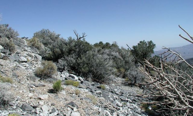
Figure 3. Shallow Limestone Slope
The reference plant community is characterized by high shrub diversity. This community is dominated by littleleaf mountain mahogany, common species include ephedra, sagebrush and spiny greasebush. Common tree species include Utah juniper and singleleaf pinyon pine. Desert snowberry, rabbitbrush, desert ceanothus and spineless horsebrush are other species associated with this site. The reference plant community is representative of a healthy late-seral condition. Small scale disturbances are required for perpetuation of littleleaf mountain mahogany on this site. Potential vegetative composition is about 10 percent grasses, 10 percent forbs, and 80 percent shrubs and trees. Approximate ground cover (basal and crown) is about 35 to 50 percent.
Figure 4. Annual production by plant type (representative values) or group (midpoint values)
Table 5. Annual production by plant type
| Plant type | Low (lb/acre) |
Representative value (lb/acre) |
High (lb/acre) |
|---|---|---|---|
| Shrub/Vine | 719 | 954 | 1188 |
| Grass/Grasslike | 90 | 120 | 150 |
| Forb | 90 | 120 | 150 |
| Tree | 1 | 6 | 12 |
| Total | 900 | 1200 | 1500 |
Community 1.2
Plant Community 1.2
This plant community is representative of a post-disturbance plant community phase. Initially, this community phase is dominated by herbaceous vegetation and woody perennials are increasing. Disturbance has removed patches of mature vegetation. Sprouting shrubs quickly recover and provide safe sites for the establishment of shrub seedlings. Periodic perturbations are important for the long term viability of mountain mahogany. Suppressed individuals are capable of surviving for 100 or more years in the understory, but once released grow rapidly.
Pathway 1.1a
Community 1.1 to 1.2
Disturbances from fire, insects or snow remove.
Pathway 1.2a
Community 1.2 to 1.1
Absence from disturbance and natural regeneration over time.
Additional community tables
Table 6. Community 1.1 plant community composition
| Group | Common name | Symbol | Scientific name | Annual production (lb/acre) | Foliar cover (%) | |
|---|---|---|---|---|---|---|
|
Grass/Grasslike
|
||||||
| 1 | Primary Perennial Grasses | 48–120 | ||||
| Indian ricegrass | ACHY | Achnatherum hymenoides | 24–60 | – | ||
| little Parish's needlegrass | ACPAD | Achnatherum parishii var. depauperatum | 24–60 | – | ||
| 2 | Secondary Perennial Grasses | 24–60 | ||||
| desert needlegrass | ACSP12 | Achnatherum speciosum | 6–24 | – | ||
| Ross' sedge | CARO5 | Carex rossii | 6–24 | – | ||
| muttongrass | POFE | Poa fendleriana | 6–24 | – | ||
|
Forb
|
||||||
| 3 | Perennial Forbs | 60–120 | ||||
| Indian paintbrush | CASTI2 | Castilleja | 6–24 | – | ||
| dyssodia | DYSSO | Dyssodia | 6–24 | – | ||
| buckwheat | ERIOG | Eriogonum | 6–24 | – | ||
| Cooper's rubberweed | HYCO2 | Hymenoxys cooperi | 6–24 | – | ||
| hoary tansyaster | MACA2 | Machaeranthera canescens | 6–24 | – | ||
| mock goldenweed | STENO7 | Stenotus | 6–24 | – | ||
| 4 | Annual Forbs | 1–24 | ||||
| cryptantha | CRYPT | Cryptantha | 6–24 | – | ||
|
Shrub/Vine
|
||||||
| 5 | Primary Shrubs | 720–1020 | ||||
| littleleaf mountain mahogany | CEIN7 | Cercocarpus intricatus | 600–780 | – | ||
| mormon tea | EPVI | Ephedra viridis | 60–120 | – | ||
| spiny greasebush | GLSP | Glossopetalon spinescens | 60–120 | – | ||
| 6 | Secondary Shrubs | 60–180 | ||||
| Bigelow sage | ARBI3 | Artemisia bigelovii | 6–24 | – | ||
| black sagebrush | ARNO4 | Artemisia nova | 6–24 | – | ||
| desert ceanothus | CEGR | Ceanothus greggii | 6–24 | – | ||
| birchleaf mountain mahogany | CEMOG | Cercocarpus montanus var. glaber | 6–24 | – | ||
| yellow rabbitbrush | CHVI8 | Chrysothamnus viscidiflorus | 6–24 | – | ||
| Heermann's buckwheat | ERHE | Eriogonum heermannii | 6–24 | – | ||
| green rabbitbrush | ERTE18 | Ericameria teretifolia | 6–24 | – | ||
| red barberry | MAHA4 | Mahonia haematocarpa | 6–24 | – | ||
| wax currant | RICE | Ribes cereum | 6–24 | – | ||
| purple sage | SADO4 | Salvia dorrii | 6–24 | – | ||
| desert snowberry | SYLO | Symphoricarpos longiflorus | 6–24 | – | ||
| spineless horsebrush | TECA2 | Tetradymia canescens | 6–24 | – | ||
| beavertail pricklypear | OPBA2 | Opuntia basilaris | 1–12 | – | ||
| Engelmann's hedgehog cactus | ECEN | Echinocereus engelmannii | 1–12 | – | ||
| Mojave kingcup cactus | ECMO | Echinocereus mojavensis | 1–12 | – | ||
|
Tree
|
||||||
| 7 | Evergreen | 1–12 | ||||
| Utah juniper | JUOS | Juniperus osteosperma | 0–6 | – | ||
| singleleaf pinyon | PIMO | Pinus monophylla | 0–6 | – | ||
Interpretations
Animal community
Livestock Interpretations: This site has limited value for livestock grazing, due to steep slopes and lack of stock water sources. Cattle and sheep will feed on littleleaf mountain mahogany to a limited extent when other forage is lacking.
Wildlife Interpretations: This site is used by a variety of wildlife species. During the summer months, this high elevation site provides a welcome refuge from the high temperatures of the lower elevations. Desert bighorns will occasionally use this site for a grazing resource. Mule deer and elk find valuable foraging habitat here. Other species that utilize this site include the coyote, bobcat and gray fox. Bird species associated with this ecological site include the bushtit, spotted towhee and broad-tailed hummingbird.
Hydrological functions
Runoff is very high and permeability is moderate. Rills are not present. A few water flow patterns may occur after summer convection storms, usually in the interspaces between shrubs. Dense shrub canopy and associated litter break raindrop impact and allow for snow capture on this site. Perennial deep-rooted grasses and forbs slow runoff and increase infiltration.
Recreational uses
Aesthetic value is derived from the diverse floral and faunal composition and the colorful flowering of wild flowers and shrubs during the spring and early summer. This site offers rewarding opportunities for photography and nature study. This site is used for hiking and potentially upland and big game hunting.
Other products
The seed of Indian ricegrass was a food staple for Native Americans.
Ephedra was traditionally used a a beverage and medicine. Native Americans made a coffee or tea-like beverage from the seeds and twigs. Many tribes still utilize the beverage today as a tonic and a blood purifier.
Tribes native to Nevada used spiny greasebush to treat tuberculosis.
Some Great Basin Native Americans used the bark for a remedy for tuberculosis, as well as for colds and other respiratory problems.
Supporting information
Type locality
| Location 1: Clark County, NV | |
|---|---|
| Township/Range/Section | T15S R60E S33 |
| Latitude | 36° 35′ 11″ |
| Longitude | 115° 15′ 17″ |
| General legal description | Approximately 9.1 kilometers east and 16.6 kilometers north of Corn Creek Station. Located in the Sheep Range, 175 meters south and 360 meters west of Sheep Peak. USGS Black Hills, NV 7.5 minute quadrangle. |
Other references
Fire Effects Information System (Online; http://www.fs.fed.us/database/feis/plants/).
USDA-NRCS Plants Database (Online; http://www.plants.usda.gov).
Contributors
E.Hourihan
P NOVAK-ECHENIQUE
Approval
Sarah Quistberg, 2/25/2025
Rangeland health reference sheet
Interpreting Indicators of Rangeland Health is a qualitative assessment protocol used to determine ecosystem condition based on benchmark characteristics described in the Reference Sheet. A suite of 17 (or more) indicators are typically considered in an assessment. The ecological site(s) representative of an assessment location must be known prior to applying the protocol and must be verified based on soils and climate. Current plant community cannot be used to identify the ecological site.
| Author(s)/participant(s) | P Novak-Echenique |
|---|---|
| Contact for lead author | State Rangeland Management Specialist |
| Date | 06/28/2011 |
| Approved by | Sarah Quistberg |
| Approval date | |
| Composition (Indicators 10 and 12) based on | Annual Production |
Indicators
-
Number and extent of rills:
None, rock fragments armor the surface. -
Presence of water flow patterns:
A few may occur after summer convection storms, usually in the interspaces between shrubs. -
Number and height of erosional pedestals or terracettes:
None -
Bare ground from Ecological Site Description or other studies (rock, litter, lichen, moss, plant canopy are not bare ground):
Typically less than 10 percent. -
Number of gullies and erosion associated with gullies:
None -
Extent of wind scoured, blowouts and/or depositional areas:
None -
Amount of litter movement (describe size and distance expected to travel):
Fine litter (foliage from grasses and annual & perennial forbs) expected to move distance of slope length (<10 ft) during intense summer convection storms or rapid snowmelt events. Persistent litter (large woody material) will remain in place except during large rainfall events. -
Soil surface (top few mm) resistance to erosion (stability values are averages - most sites will show a range of values):
Soil stability values should be 3 to 6 on most soil surface textures found on this site. -
Soil surface structure and SOM content (include type of structure and A-horizon color and thickness):
Soil surface structure is weak coarse subangular blocky. Soil surface colors are dark grayish brown and soils are typified by a mollic epipedon. Organic matter of the surface 2 to 5 inches is 1 to 2 percent. -
Effect of community phase composition (relative proportion of different functional groups) and spatial distribution on infiltration and runoff:
Dense shrub canopy and associated litter break raindrop impact and allow for snow capture on this site. Perennial deep-rooted grasses and forbs slow runoff and increase infiltration. -
Presence and thickness of compaction layer (usually none; describe soil profile features which may be mistaken for compaction on this site):
None. Massive subsurface horizons should not be mistaken for compaction. -
Functional/Structural Groups (list in order of descending dominance by above-ground annual-production or live foliar cover using symbols: >>, >, = to indicate much greater than, greater than, and equal to):
Dominant:
Reference Plant Community: Evergreen shrubsSub-dominant:
Deciduous shrubs > deep-rooted, cool-season perennial grasses > deep-rooted perennial forbsOther:
Grass-like plants, annual forbs, evergreen treesAdditional:
-
Amount of plant mortality and decadence (include which functional groups are expected to show mortality or decadence):
Dead branches within individual shrubs common and standing dead shrub canopy material may be as much as 25% of total woody canopy. Mature bunchgrasses commonly have (~20%) have dead centers. -
Average percent litter cover (%) and depth ( in):
Total litter (in interspaces and under canopy) ranges from 15 to 30 percent and is less than 1/2 inch in depth. -
Expected annual annual-production (this is TOTAL above-ground annual-production, not just forage annual-production):
For average growing season 1200 lbs/ac. Favorable years is 1500 lbs/ac and unfavorable years is 900 lbs/ac. -
Potential invasive (including noxious) species (native and non-native). List species which BOTH characterize degraded states and have the potential to become a dominant or co-dominant species on the ecological site if their future establishment and growth is not actively controlled by management interventions. Species that become dominant for only one to several years (e.g., short-term response to drought or wildfire) are not invasive plants. Note that unlike other indicators, we are describing what is NOT expected in the reference state for the ecological site:
Potential invaders on this site include cheatgrass. -
Perennial plant reproductive capability:
All functional groups should reproduce in average and above-average growing seasons. Less reproduction will occur in below-average precipitation years.
Print Options
Sections
Font
Other
The Ecosystem Dynamics Interpretive Tool is an information system framework developed by the USDA-ARS Jornada Experimental Range, USDA Natural Resources Conservation Service, and New Mexico State University.
Click on box and path labels to scroll to the respective text.